
East Coast Nor’easter May Miss the Mark While Midwest Severe Storm Threat Targets Illinois, Missouri, Iowa, Indiana and Kentucky
UNITED STATES — A split in the forecast pattern is creating two very different weather stories heading into late February: a potential nor’easter along the East Coast that may struggle to organize, and a more immediate severe weather setup taking shape across parts of the Midwest and Ohio Valley.
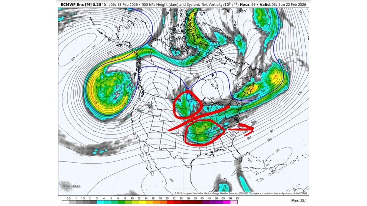
Recent upper-level model guidance shows why forecasters remain cautious about the coastal storm while raising concern for Thursday’s severe threat farther inland.
East Coast Nor’easter Signal Growing — But Pattern May Not Fully Phase
There is a growing signal for a nor’easter Sunday into Monday, particularly off the Mid-Atlantic and Northeast coastline. However, 500mb height and anomaly maps suggest the larger-scale pattern may not align in time for a significant coastal storm.
The ECMWF ensemble guidance highlights:
- A ridge positioned over the Rockies, but slightly too far east.
- Interaction between a potential southern stream disturbance and the “50/50 low” near the Canadian Maritimes.
- Energy from the southern branch sliding offshore before fully phasing with northern energy.
This setup could result in:
- A later phase offshore.
- A weaker or more glancing blow for the Eastern U.S.
- Heavier precipitation remaining primarily over the Atlantic.
Instead of a benchmark-tracking nor’easter delivering widespread snow from Washington, D.C. to Boston, the current configuration favors a flatter, more open wave. That would limit snowfall impacts across Pennsylvania, New Jersey, New York, and New England.
Ensemble storm location plots show a wide spread of possible low-pressure centers offshore on February 22, many tracking southeast of the traditional benchmark. While some members indicate stronger lows in the 980s or even 970s hPa range, clustering remains scattered — reinforcing uncertainty.
At this range, the pattern suggests that unless northern and southern stream energy phase more efficiently, the East Coast could see a near-miss rather than a direct hit.
500mb Setup Explains Why Surface Maps May Be Misleading
Upper-level analysis shows the ridge axis over the western U.S. is not ideally positioned to force a deeper trough into the East. Instead, more interaction occurs between upstream energy and the 50/50 low, disrupting timing.
As a result:
- The southern energy ejects eastward.
- Phasing occurs too late and too far offshore.
- Surface low development strengthens over water rather than inland.
Forecasters caution that surface maps alone won’t capture this nuance. The real story lies at 500mb, where timing and placement of shortwaves determine whether a blockbuster nor’easter materializes — or fizzles offshore.
Midwest and Ohio Valley Severe Threat Increasing for Thursday
While East Coast snow lovers watch model trends, attention is shifting to a more immediate and potentially impactful setup across the Midwest.
Guidance indicates the highest severe potential may shift into:
- Eastern Missouri
- Southeast Iowa
- Much of Illinois
- Parts of Indiana
- Western Kentucky
Forecast ingredients include:
- A strong 50–70 knot jet core.
- Mid to upper 50s dew points pooling along a subtle dryline bulge.
- Favorable hodograph curvature indicating strong wind shear.
- Sufficient 0–3 km surface-based CAPE.
CSU-MLP and SPC Day 3 severe probability maps highlight a corridor centered over Illinois and surrounding states. The risk area supports the possibility of isolated supercells ahead of a lifting warm front as drier air pushes in behind it.
If trends continue, all hazards could be on the table:
- Damaging straight-line winds
- Large hail
- Tornadoes
Radar simulation panels show discrete cells developing along a north-south oriented boundary, particularly near eastern Missouri into west-central Illinois before advancing eastward into Indiana.
Timing and What to Watch
For the Midwest severe threat:
- Thursday afternoon and evening appear to be the primary window.
- Supercells may initially form in eastern Missouri and southeast Iowa.
- Storms could intensify as they move into Illinois and possibly Indiana and Kentucky.
For the East Coast:
- Sunday afternoon through Monday morning remains the general window for any coastal low.
- Track and phasing details will determine whether snowfall impacts remain offshore or reach inland areas.
Bottom Line
The late-February pattern is complex and highly dependent on upper-level timing.
- The East Coast nor’easter has potential but currently favors a weaker or offshore solution unless phasing improves.
- The Midwest severe setup appears more immediate and increasingly organized, particularly across Illinois, Missouri, Iowa, Indiana and Kentucky.
Residents in the Midwest should monitor updates closely ahead of Thursday’s severe weather window. Meanwhile, those along the Mid-Atlantic and Northeast coast should watch trends through the week as ensemble guidance refines storm track and strength.
WaldronNews.com will continue tracking both systems and provide updates as confidence increases.