
East Coast Winter Storm Forecast Shows Dry Air Intrusion Could Create Sharp Snowfall Swings Across the Carolinas and Mid-Atlantic
UNITED STATES — Forecasters are warning that large differences in snowfall totals are likely across the Carolinas and parts of the Mid-Atlantic this weekend, not because the storm is weak, but because pockets of dry air at mid-levels could disrupt snowfall efficiency, according to ECMWF atmospheric moisture data.
The setup helps explain why some communities could see near-historic snow totals, while nearby locations receive only a few inches despite being under the same storm system.
Mid-Level Dry Air Is the Key Forecast Challenge
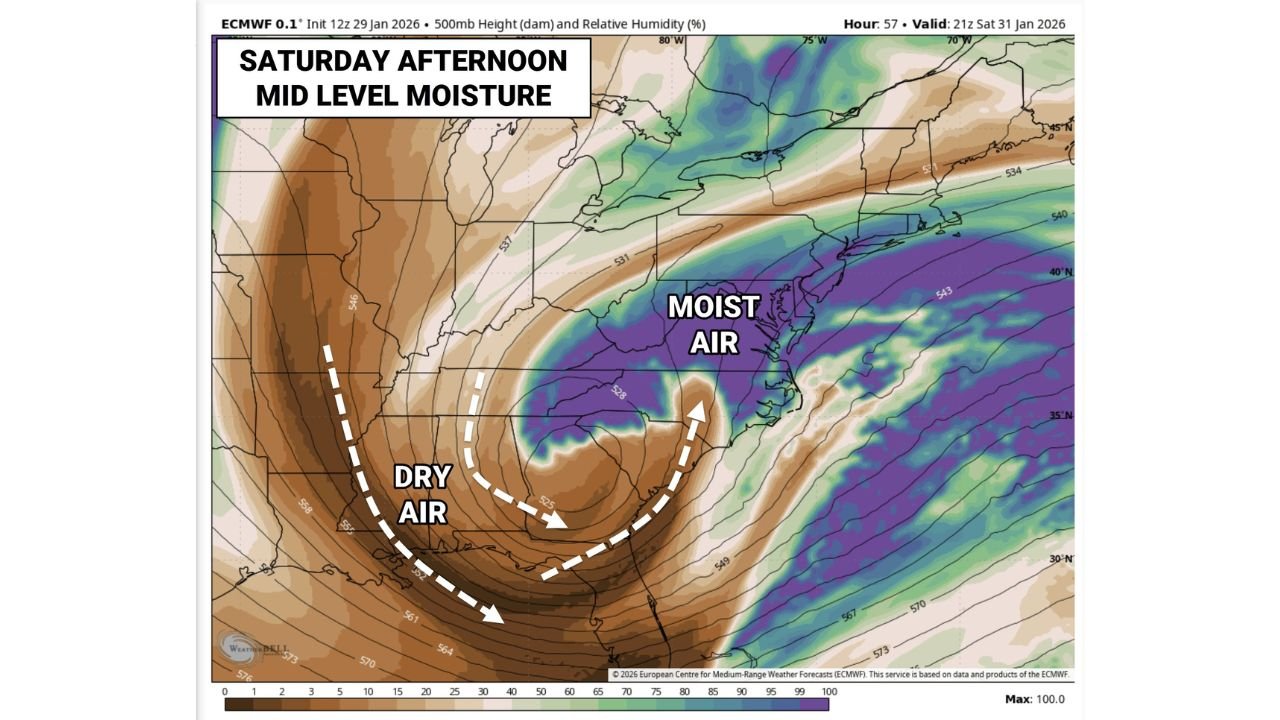
The ECMWF 500-mb height and relative humidity maps for Saturday afternoon show a pronounced dry air slot wrapping into the western and southern side of the storm, while deep moisture remains concentrated closer to the coast.
- Brown and tan shading indicates dry mid-level air
- Purple and green shading highlights moist air capable of producing heavy snow
- The boundary between these zones is tight and unstable
This pattern makes snowfall highly dependent on exact storm placement, with small shifts determining whether an area sees heavy snow or much lower totals.
Why Snow Totals May Vary So Dramatically
Forecasters compare this setup to scattered thunderstorms, where one town gets drenched while another nearby stays mostly dry.
In this case:
- Areas fully embedded in moist air could see 6 to 10 inches or more
- Locations affected by dry air intrusion may struggle to reach 2 to 4 inches
- Eastern and coastal zones are more likely to remain in the moisture-rich zone
The presence of dry air can suppress snowfall rates, even when temperatures are cold enough for snow.
Snow Ratios Amplify Small Moisture Differences
The forecast also features very high snow-to-liquid ratios near 20:1, meaning small differences in moisture can result in big differences in accumulation.
To put that in perspective:
- 2 inches of snow may equal as little as 0.05 inches of liquid
- 8 inches of snow may only require 0.40 inches of liquid
- Minor moisture variations can therefore quadruple snowfall totals
This is why forecasters are staying cautious on widespread high-end totals, even though isolated locations could overperform.
Coastal Areas Still Have the Highest Upside
The ECMWF data suggests coastal sections of the Carolinas and Mid-Atlantic have the best chance of staying within the moist air shield for a longer period.
These areas are more likely to experience:
- Sustained snowfall rates
- Higher accumulations over shorter timeframes
- Less interference from dry air wrapping into the storm
However, even coastal locations could see sharp gradients depending on the storm’s exact evolution.
Why Confidence Is Higher in Variability Than Exact Totals
Forecasters stress that confidence is high that snowfall totals will vary widely, but lower on exactly where the highest totals will land.
This makes the event especially challenging for travel planning and emergency response, as impacts could change dramatically over short distances.
What This Means for Arkansas
While Arkansas is not in the path of this storm, the pattern illustrates a highly active and volatile winter setup across the United States, with strong jet-stream dynamics and sharp air-mass boundaries.
These ingredients can quickly shift and influence future systems that may impact the South-Central region later in the season.
Stay with WaldronNews for continued winter storm analysis, forecast updates, and breakdowns of complex weather patterns affecting the country.