
East Texas, Southeast Oklahoma, and Arkansas See Expanding Low-Level Saturation as Cloud Layers Signal Increasing Overcast and Damp Conditions
UNITED STATES — Satellite analysis from GOES nighttime microphysics imagery shows low-level atmospheric saturation spreading into East Texas, while upper-level cloud cover continues streaming across the Southern Plains. The evolving cloud structure points toward a thickening overcast, reduced radiational cooling overnight, and the potential for damp, gray conditions to expand eastward.
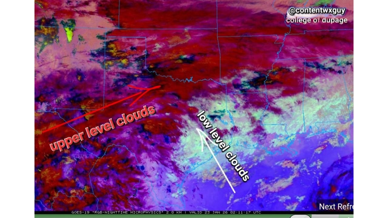
What the Satellite Imagery Is Showing
The color-enhanced satellite imagery clearly separates cloud layers by altitude:
- Upper-level clouds (deep reds and magentas) are stretched across West Texas, Oklahoma, and the central Plains, indicating high-altitude moisture riding fast upper-level flow.
- Low-level clouds (lighter blues, greens, and purples) are becoming more dominant across East Texas, signaling near-surface moisture saturation.
This combination suggests moisture is increasing from the ground up, rather than precipitation falling from higher cloud decks alone.
Low-Level Saturation Pushing East Into Texas
Low-level saturation is particularly important because it often leads to:
- Persistent stratus clouds
- Drizzle or mist
- Patchy fog, especially overnight and during early morning hours
- Limited daytime warming
As moisture deepens near the surface, temperatures can become locked in a narrow range, keeping conditions cooler and more uncomfortable even without steady rainfall.
Why Upper-Level Clouds Matter Here
While upper-level clouds alone don’t usually cause surface impacts, they play a critical role by:
- Trapping heat overnight
- Limiting daytime solar heating
- Enhancing lift when combined with low-level moisture
When upper- and low-level cloud decks overlap—as seen in this imagery—the result is often widespread overcast with slow-moving or stagnant weather patterns.
Areas Most Likely to Be Affected
Based on the satellite presentation, the highest impact zone includes:
- East Texas
- Southeast Oklahoma
- Western and central Arkansas
- Portions of northwestern Louisiana
These areas are most likely to see cloud thickening, low ceilings, and occasional drizzle, especially during the overnight and morning periods.
What This Means Going Forward
If low-level saturation continues to deepen:
- Fog risk will increase, particularly near sunrise
- Travel conditions may deteriorate due to reduced visibility
- Temperatures may stay cooler than forecast
- Any approaching disturbance could quickly generate light rain or drizzle
While this setup does not immediately signal severe weather, it does point to prolonged gloomy, damp conditions that can linger for multiple forecast cycles.
Waldron will continue monitoring satellite trends and model guidance to determine how long this low-level saturation persists and whether it evolves into more organized precipitation. Stay weather-aware, especially during the overnight and early morning hours.