
Eastern U.S. Atmospheric Pattern Suggests Warm Ridge Over Northeast While Much of the Country Remains Cold
UNITED STATES — A striking contrast between upper-atmosphere patterns and actual surface temperatures is emerging across the United States, highlighting how large-scale atmospheric signals do not always translate directly into warm or cold weather on the ground.
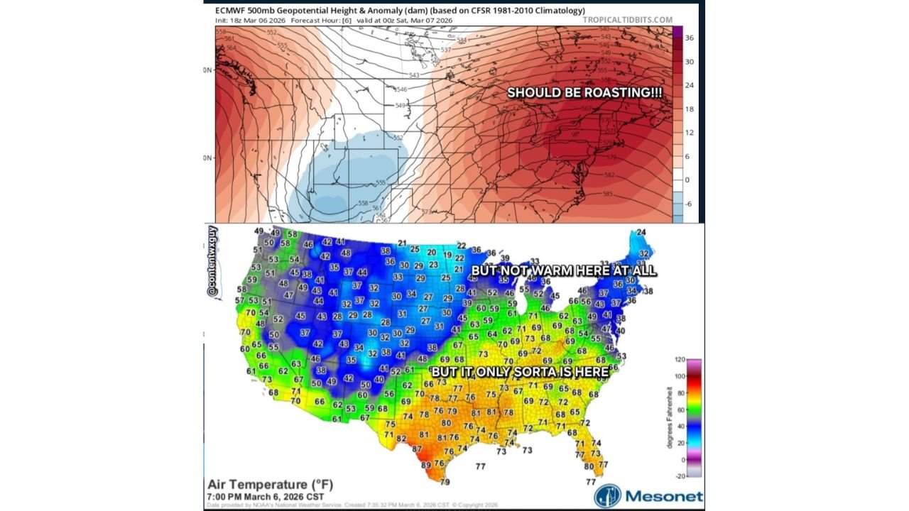
Recent atmospheric analysis of the 500 millibar geopotential height pattern, a key measure used to study upper-level pressure systems, shows a strong ridge of high pressure stretching across the eastern United States and the Northeast. In meteorological terms, such a ridge is often associated with warmer-than-average conditions.
However, real-world temperature readings across the country show a far more complex picture.
Upper-Level Pattern Suggests Warmth Across the East
The 500 mb height anomaly map displays above-average pressure heights across the eastern half of the United States, represented by widespread red shading on the map.
These positive height anomalies typically indicate:
- Stronger upper-level ridging
- Sinking air and more stable conditions
- A pattern often associated with warmer weather
Under many circumstances, such a pattern would allow temperatures across the Mid-Atlantic, Northeast, and Great Lakes regions to climb significantly above seasonal averages.
In theory, this setup would suggest that much of the eastern United States should be experiencing relatively warm conditions.
Surface Temperatures Tell a Different Story
Actual temperature observations across the United States reveal a much different situation at ground level.
A nationwide temperature map from Friday evening shows large portions of the northern and western United States remaining much colder, particularly across the Rocky Mountains, Northern Plains, and Upper Midwest.
Temperatures across many northern states were recorded in the 20s and 30s, including parts of:
- Montana
- Wyoming
- North Dakota
- South Dakota
- Minnesota
Even parts of the Great Lakes region and northern New England were still experiencing temperatures near or below freezing.
Meanwhile, the warmest air was concentrated across the southern United States, where temperatures climbed into the 70s and even 80s in several areas.
Southern States See Spring-Like Warmth
While colder air dominated much of the northern United States, a large portion of the southern tier experienced much warmer conditions.
Temperatures reached the 70s across parts of the Southeast and the Lower Mississippi Valley, including states such as:
- Texas
- Louisiana
- Mississippi
- Alabama
- Georgia
In portions of southern Texas, temperatures approached the upper 80s, showing a stark contrast to the cold air farther north.
This north–south divide created a classic early-spring weather pattern across the country.
Why Upper-Level Patterns Don’t Always Match Surface Temperatures
The contrast between the atmospheric ridge and the surface temperatures illustrates an important principle in weather forecasting.
The 500 mb pattern describes conditions several miles above the Earth’s surface, but surface weather is influenced by many additional factors, including:
- Cold air trapped near the ground
- Snow cover reflecting sunlight
- Recent cold air masses lingering in place
- Regional terrain effects
Because of these influences, upper-level warmth does not always immediately translate to warmer surface conditions.
Early Spring Patterns Often Produce Complex Temperature Maps
During late winter and early spring, the United States often experiences complex temperature distributions as colder winter air masses gradually retreat northward.
Warm air from the Gulf of Mexico frequently pushes north into the southern states, while colder air remains entrenched across the northern Plains and mountain regions.
This transition period can produce dramatic temperature contrasts across the country, with spring-like warmth in the South and winter-like conditions still lingering farther north.
Weather Patterns Continue to Shift
As the upper-level pattern evolves in the coming days, temperatures across parts of the United States could begin shifting as warmer air gradually spreads northward.
However, early spring weather patterns often change quickly, and additional cold air surges remain possible across northern states.
For now, the current pattern highlights the complexity of forecasting weather across a large and diverse country.
Stay with WaldronNews for continuing coverage of major weather patterns and developing forecasts across the United States.