
Eastern U.S. Forecast Flips Colder: Great Lakes, Midwest and Ohio Valley Bracing for Brief Late-February Chill as Models Correct Warmer Bias
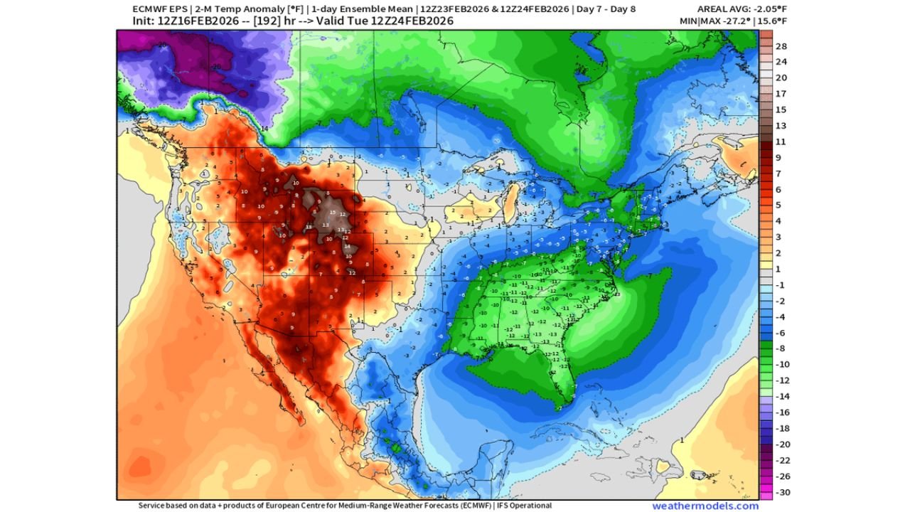
UNITED STATES — A noticeable correction in the latest ensemble data now shows a stronger and more widespread shot of colder air spreading across the eastern half of the country, especially from the Great Lakes through the Midwest and into the Ohio Valley. Earlier model runs appeared to underdo the cold, but mid-day updates have shifted significantly cooler, reinforcing that winter is not finished yet.
This does not signal a locked-in long-term Arctic pattern — but it does confirm a meaningful, short-lived cooldown heading into late February.
Colder Trends Expand Across the Great Lakes and Midwest
The updated ensemble temperature anomaly maps highlight below-normal readings across:
- Michigan
- Wisconsin
- Illinois
- Indiana
- Ohio
- Pennsylvania
- New York
Much of this region is trending 2° to 10° below seasonal averages, with locally stronger anomalies over parts of Michigan, northern Ohio, and western New York.
The key takeaway: forecast confidence has increased in a brief but widespread eastern cooldown.
Ohio Valley and Interior Northeast See Strongest Signal
The deepest cold anomalies appear centered from:
- Northern Illinois and Indiana
- Lower Michigan
- Ohio and western Pennsylvania
- Upstate New York
Shaded greens and blues across these areas indicate below-normal temperatures, with pockets of darker shading suggesting the potential for even cooler departures from average.
This kind of correction often means models previously underestimated the strength of the incoming air mass.
Western U.S. Remains Warm — Pattern Not Locked In
While the East trends colder, the West shows strong warmth building across:
- California
- Nevada
- Arizona
- Utah
- Idaho
This east-west contrast confirms the pattern is likely progressive, not stagnant — meaning the colder air should move through rather than settle in long term.
That’s important: this looks like a reminder shot of winter, not a multi-week deep freeze.
What This Means for the Great Lakes Region
For cities such as:
- Chicago, Illinois
- Detroit, Michigan
- Cleveland, Ohio
- Milwaukee, Wisconsin
- Buffalo, New York
Expect:
- Colder daytime highs compared to recent trends
- Chilly overnight lows
- Reinforced late-winter feel
While this specific data set focuses on temperatures rather than storm systems, colder air in place can increase the impact of any passing disturbances.
Timing of the Cold Push
The anomaly window targets late February into early March, with ensemble comparisons showing the colder shift strengthened compared to prior runs.
That mid-day correction adds credibility to the cooler trend.
Bottom Line
The eastern United States — especially the Great Lakes, Midwest, and Ohio Valley — should prepare for a brief but noticeable dip in temperatures heading into late February.
It won’t be a season-defining Arctic outbreak. But it will be enough to remind residents that winter still has a voice before the seasonal transition truly takes hold.
WaldronNews.com will continue monitoring updated model trends for any shifts in strength, duration, or added storm potential tied to this colder air mass.