
Eastern U.S. Put on Early Summer Alert as First 90 Degree Heat and Drought Risk Targets Mid Atlantic and Southeast Next Week
UNITED STATES — A significant early-season weather shift is now unfolding across the eastern half of the country, with unseasonably hot temperatures and emerging drought concerns expected to intensify through mid to late April.
The latest outlook highlights a widespread surge of above-normal temperatures across the East, with some areas potentially reaching or exceeding 90°F for the first time in 2026.
Heat Expands Across the Eastern United States
From Texas to the Northeast, a large portion of the country is forecast to experience well above-average temperatures between April 15 and April 19.
The most intense warmth is expected across:
- Mid-Atlantic states including Virginia, Maryland, and the Carolinas
- Southeast region, especially Georgia, South Carolina, and parts of Florida
- Portions of the Ohio Valley and Northeast, including Pennsylvania and New York
This setup signals a broad, early-season heat wave pattern, unusual for mid-April.
First 90 Degree Readings of the Year Possible
Forecast signals suggest:
- Some cities in the Mid-Atlantic and Southeast could hit 90°F or higher
- This would mark the first true summer-like heat surge of the year
- Warm overnight temperatures may also limit cooling, adding to discomfort
This level of heat arriving this early can catch many off guard, especially with spring conditions still ongoing just days prior.
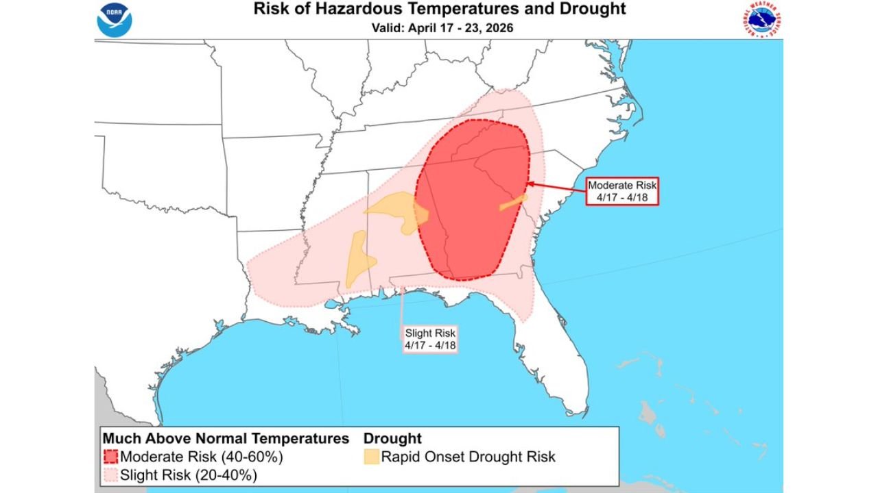
Drought and Fire Concerns Begin to Build
Alongside the heat, the pattern raises concerns about rapid drying conditions.
A developing risk zone includes:
- Carolinas and Georgia, where a moderate risk of hazardous heat and drought is highlighted
- Broader parts of the Southeast, where a slight risk of drought development exists
These conditions could lead to:
- Drying soils and vegetation
- Increased wildfire potential
- Stress on agriculture and water resources
Why This Pattern Matters
This setup is not just about heat — it’s about timing and impact:
- Arriving early in the season, it can accelerate drought formation
- Vegetation that has not fully matured may dry out faster
- The combination of heat + dryness increases overall risk
This is especially important across regions that may already be dealing with limited recent rainfall.
Areas Most at Risk
The highest concern zone currently includes:
- Virginia, North Carolina, South Carolina
- Parts of Georgia and Tennessee
- Expanding into surrounding areas of the Southeast and Mid-Atlantic
These regions are highlighted for moderate risk of hazardous temperatures and developing drought between April 17 and April 18.
What to Watch Going Forward
As this pattern develops:
- Temperatures could trend even higher than currently forecast
- Drought conditions may expand or intensify
- Fire weather concerns could increase, especially in dry, windy areas
Bottom Line
The eastern United States is entering a potentially impactful early heat and drying pattern.
With 90-degree temperatures possible, drought signals increasing, and wildfire concerns emerging, this is a setup that demands attention heading into mid-April.
Residents across the Mid-Atlantic and Southeast should prepare for a sudden shift toward summer-like conditions — much earlier than normal.