
EURO Model Paints Major Snow Band From Pennsylvania to New York and Southern New England as Coastal Low Tracks Near Mid-Atlantic — 6 to 18+ Inches Possible If Setup Holds
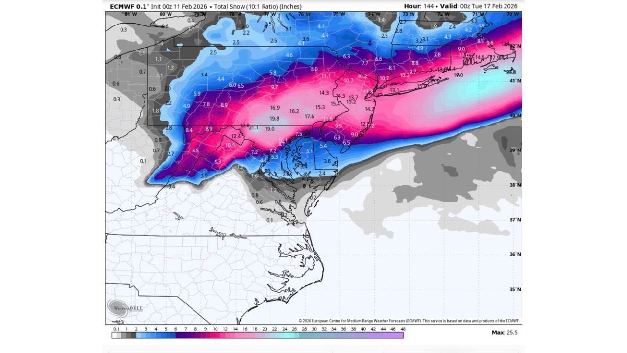
UNITED STATES — The latest 00Z European (EURO) model run, about 120 hours out, is keeping a significant winter storm signal alive for the Mid-Atlantic and Northeast — with a heavy snow axis stretching from central Pennsylvania through northern New Jersey, southeastern New York, and into southern New England.
While still several days away and subject to change, the current projection suggests a strong coastal low organizing off the Mid-Atlantic coast and intensifying as it tracks northeast.
Heavy Snow Axis: Pennsylvania to Long Island and Southern New England
The deterministic EURO snowfall output (10:1 ratio) shows a concentrated band of substantial accumulation across:
- Central and eastern Pennsylvania
- Northern and central New Jersey
- Southeastern New York
- Long Island
- Connecticut
- Rhode Island
- Massachusetts
Within this corridor, modeled snowfall totals range widely but include pockets of:
- 6 to 10 inches across broader areas
- 10 to 15 inches in parts of eastern Pennsylvania and northern New Jersey
- Isolated higher amounts exceeding 15 inches in localized bands
Farther north into upstate New York and interior New England, lighter but still notable snowfall is indicated.
Coastal Low Position Critical for Snow/Rain Line
The accompanying surface map shows a deepening low pressure center offshore of the Mid-Atlantic coast. Its exact track will be critical in determining:
- How far inland heavier precipitation pushes
- Where the rain/snow line sets up
- Whether coastal areas mix with rain or stay all snow
Currently, the heavier rain shield is projected offshore and across parts of coastal Virginia and North Carolina, while colder air holds firm across Pennsylvania, New Jersey, and New York.
A slight westward jog in the storm track could introduce more mixing along the I-95 corridor. A slightly eastward track would favor even heavier snowfall inland.
Snowfall Gradient Likely Sharp
The model depicts a tight gradient on the southern edge of the heavy snow band, particularly near:
- Southern New Jersey
- Coastal Maryland
- Portions of Delaware
This means snowfall totals could change dramatically over short distances depending on storm evolution.
Timing Window: Early to Midweek Period
The projected valid time on the model suggests impacts occurring around February 16–17, with the storm maturing overnight into early Tuesday.
Given the 120-hour lead time, this is still within the window where track and intensity shifts are common.
Not Over Yet for Winter
Despite recent fluctuations in guidance, this run indicates winter may not be done across the Northeast. With a favorable cold air supply in place and a coastal low developing in a classic position, the ingredients remain supportive of a notable snowfall event if current trends persist.
However, ensemble spread and future model cycles will determine whether this remains a high-impact snowstorm or trends weaker or farther offshore.
Residents across:
- Pennsylvania
- New Jersey
- New York
- Connecticut
- Rhode Island
- Massachusetts
should continue monitoring updated forecasts in the coming days.
Waldronnews.com will track subsequent EURO, GFS, and ensemble guidance to see whether this potential winter storm strengthens or shifts as we move closer to the event window.