
European Model Turns Colder for Midweek Storm, Signals Snow and Wintry Mix From Pennsylvania and New Jersey Into New York City While GFS Trends Slightly South
UNITED STATES — With the previously anticipated Sunday night system now officially off the table, attention has shifted to a new potential winter threat developing for mid next week — and the European model is taking a noticeably colder and more aggressive stance than its American counterpart.
The latest ECMWF guidance paints a wintry scenario stretching from Pennsylvania and New Jersey into the New York City metro and southern New England, while the GFS remains somewhat warmer and has trended slightly farther south.
What the European Model Is Showing
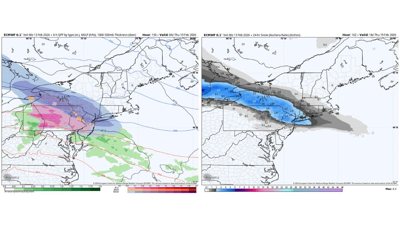
The ECMWF 0.1° run valid early Thursday, February 19, shows a broad shield of precipitation moving through the Mid-Atlantic and Northeast with colder air entrenched across interior areas.
The 6-hour precipitation-type panel indicates:
- A snow band across central and northern Pennsylvania
- Snow extending into northern and central New Jersey
- Accumulating snow reaching into parts of the New York City metro
- A transition zone of sleet and freezing rain near southern New Jersey and the Delmarva region
- Plain rain farther south across portions of Maryland and coastal areas
Thickness lines and surface pressure placement suggest the European model is holding colder air more firmly in place compared to GFS.
Snowfall Totals From the Euro
The 24-hour snowfall (Kuchera ratio) projection highlights a swath of measurable snow running west to east across:
- Central and eastern Pennsylvania
- Much of New Jersey
- The New York City region
- Portions of Long Island
Projected totals in the current run generally fall in the 2 to 4 inch range, with localized amounts approaching or slightly exceeding 4 inches in parts of:
- Eastern Pennsylvania
- Central New Jersey
- Areas just northwest of New York City
Farther north into upstate New York and interior New England, totals appear lighter in this particular run, indicating the storm’s primary focus is along the I-78 to I-95 corridor.
Key Cities in the Potential Impact Zone
Based on the European model depiction, cities that could see accumulating snow include:
- Philadelphia
- Trenton
- Newark
- New York City
- Portions of Long Island
South of that band, including parts of southern New Jersey and Delaware, precipitation type becomes more mixed, reducing overall snowfall totals.
How This Compares to the GFS
The GFS model remains less aggressive with cold air and has nudged the system slightly south compared to earlier runs.
Key differences:
- GFS keeps the heavier snow axis farther south
- Euro drives colder air deeper into the Mid-Atlantic and Northeast
- The rain-snow line is farther north in the Euro solution
These differences are subtle in track but significant in impact. A 50–75 mile shift in storm track or temperature profile could dramatically change snowfall totals in highly populated areas.
Why This Setup Is Tricky
Midweek storms in this pattern often hinge on:
- The exact placement of the surface low
- Strength of cold high pressure to the north
- Timing of warm air advection aloft
- Boundary-layer temperatures near the coast
The European model appears to be recognizing a stronger cold air presence, while the GFS suggests more marginal conditions.
At this range, both solutions remain plausible.
What Needs to Happen for Higher Snow Totals
For the Euro solution to verify more broadly:
- Cold air must hold across New Jersey and New York
- The surface low must track favorably offshore
- Warm air intrusion aloft must remain limited
If warmer air pushes north more aggressively, snowfall totals would shrink and shift inland.
Bottom Line
The Sunday system may be gone, but the midweek threat is gaining attention — especially given the colder European model trend.
At this stage, accumulating snow from Pennsylvania through New Jersey and into New York City is on the table, but confidence remains moderate due to model disagreement.
Small adjustments over the next 24–48 hours will determine whether this becomes a widespread I-95 corridor snowfall or a more suppressed and mixed event.
WaldronNews.com will continue monitoring model trends and provide updated projections as the midweek storm picture becomes clearer.