
Extreme Morning Cold Grips Massachusetts, Connecticut, and Rhode Island as Subzero Pockets Linger and Light Snow Targets Region Tuesday Evening
UNITED STATES — A bitterly cold start is underway across Massachusetts, Connecticut, and Rhode Island, with a Cold Weather Advisory remaining in effect until 10 a.m. for all of Connecticut and much of eastern Massachusetts east of I-495.
Most communities across southern New England woke up in the single digits, while several radiational cooling pockets dropped well below zero, marking one of the coldest mornings of the season for interior locations.
Subzero Cold Spots Identified Across MA and CT
Two distinct pockets of extreme cold developed overnight:
- Northwest Massachusetts, where Williamstown fell to −14°F
- South-central Massachusetts into extreme northern Connecticut, with:
- Hampden, MA near −12°F
- Wilbraham, MA around −8°F, including the Ludlow area
- Somers, CT down to −9°F
These temperatures were driven by clear skies, calm winds, and strong overnight radiational cooling.
Daytime Temperatures Improve but Remain Below Average
Despite the frigid start, temperatures are expected to recover slightly today, with afternoon highs climbing into the 20s for most locations. While still well below seasonal norms, this represents an improvement from recent days.
Another cold night is expected tonight, particularly inland areas where single-digit lows are likely once again.
Gradual Warm-Up Through the Week
Forecast data shows a moderating temperature trend beginning midweek:
- Highs gradually rising into the 30s
- Conditions trending toward near-seasonable to slightly below-seasonable levels
- By Sunday, highs in the 35–40°F range are possible across much of southern New England
After the recent extreme cold, these temperatures will feel noticeably milder.
Clipper System Brings Light Snow Tuesday Evening
The primary weather feature this week is a weak clipper system expected to move through Tuesday late afternoon into Tuesday night.
Timing:
- Around 4 p.m., give or take
- Ending near midnight
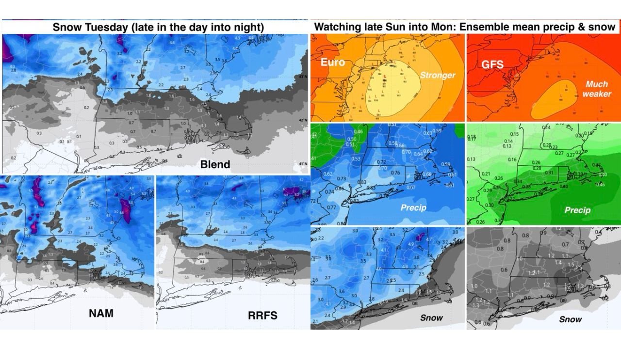
Snowfall expectations based on model guidance:
- Connecticut and Rhode Island: A coating to 1 inch
- Massachusetts: 1–3 inches, with highest totals (2–3 inches) north of the Massachusetts Turnpike
- Southeastern Massachusetts: Some uncertainty due to possible mixing, making amounts less certain
While not a major storm, the system could impact the evening commute.
Quiet Weather Returns After Tuesday
Following the clipper, dry and mostly sunny weather is expected to dominate through the remainder of the week and into the weekend.
Forecasters are also monitoring a potential system late Sunday into Monday, but confidence remains low. Ensemble guidance from the European model is more robust than the GFS, which keeps the system weaker and farther south.
At this time, that late-weekend system remains something to watch, not a certainty.
Bottom Line
- Dangerous cold early today with subzero pockets
- Gradual warming trend begins midweek
- Light snow possible Tuesday evening
- Quiet weather dominates afterward
WaldronNews.com will continue tracking temperature trends and snowfall potential across Massachusetts, Connecticut, and Rhode Island, with updates as confidence increases.