
Fast-Moving Alberta Clipper Wednesday Followed by Rain-Snow Mix Threat Friday Across Pennsylvania, New Jersey and New York
MID-ATLANTIC & NORTHEAST — Just as the blockbuster nor’easter begins to pull away, forecasters are already tracking two additional snow chances later this week that could bring fresh impacts to Pennsylvania, New Jersey and New York.
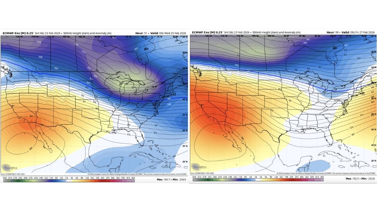
New upper-level data shows a fast-moving pattern setting up across the northern United States, with two shortwave systems expected to sweep through on Wednesday and Friday.
Wednesday: Classic Alberta Clipper Setup
Model guidance indicates Wednesday’s system will resemble a classic Alberta clipper, diving southeast out of central Canada and racing through the Great Lakes into the Northeast.
The 500mb height maps show:
- Strong northwest flow aloft
- A quick-moving disturbance sliding across the Upper Midwest
- Cold air firmly in place over Pennsylvania, New Jersey and New York
Clippers are typically fast but can produce bursts of light to moderate snow, especially in:
- Interior Pennsylvania
- Northern and western New Jersey
- Upstate and central New York
While not expected to be a major storm, even a few inches could create slick travel conditions given the fresh snowpack left behind by the recent blizzard.
Friday: A More Complex System With Mixed Precipitation
The second system arrives Friday and appears more complicated.
Upper-level maps show a flatter but moisture-bearing wave sliding in from the west. Unlike Wednesday’s clipper, this setup may introduce warmer air into parts of the Mid-Atlantic.
That could mean:
- Snow in interior Pennsylvania and upstate New York
- A rain-snow mix in southern New Jersey
- Potential mixed precipitation in parts of the New York City metro
Temperatures will be critical in determining how this system unfolds.
If colder air holds longer, snowfall totals could increase. If warmer air surges in faster, rain may limit accumulations in coastal areas.
Pattern Remains Progressive
The overall pattern suggests:
- No long-duration systems
- Fast-moving waves
- Brief but impactful snow chances
Unlike the recent slow-moving nor’easter, both upcoming systems appear progressive, meaning impacts may be shorter-lived but still disruptive.
What This Means for the Region
With the ground already snow-covered and crews still clearing from the blizzard, even minor additional snowfall could:
- Complicate cleanup efforts
- Create new travel hazards
- Slow power restoration in affected areas
Residents across Pennsylvania, New Jersey and New York should remain weather-aware through the end of the week.
Bottom Line
The major East Coast blizzard may be ending, but winter isn’t finished yet.
A quick-hitting Alberta clipper Wednesday could bring fresh snow to interior areas, followed by a Friday system that may introduce a mix of rain and snow across parts of the Mid-Atlantic and Northeast.
WaldronNews.com will continue monitoring both systems and provide updates as confidence in track and totals increases.