
Fast-Moving Clipper Brings Accumulating Snow to Southern New England Late Tuesday, With Heaviest Totals North of the Coast
SOUTHERN NEW ENGLAND — A fairly potent clipper system is expected to sweep across Southern New England late Tuesday into very early Wednesday, bringing a brief but impactful period of accumulating snow before exiting the region.
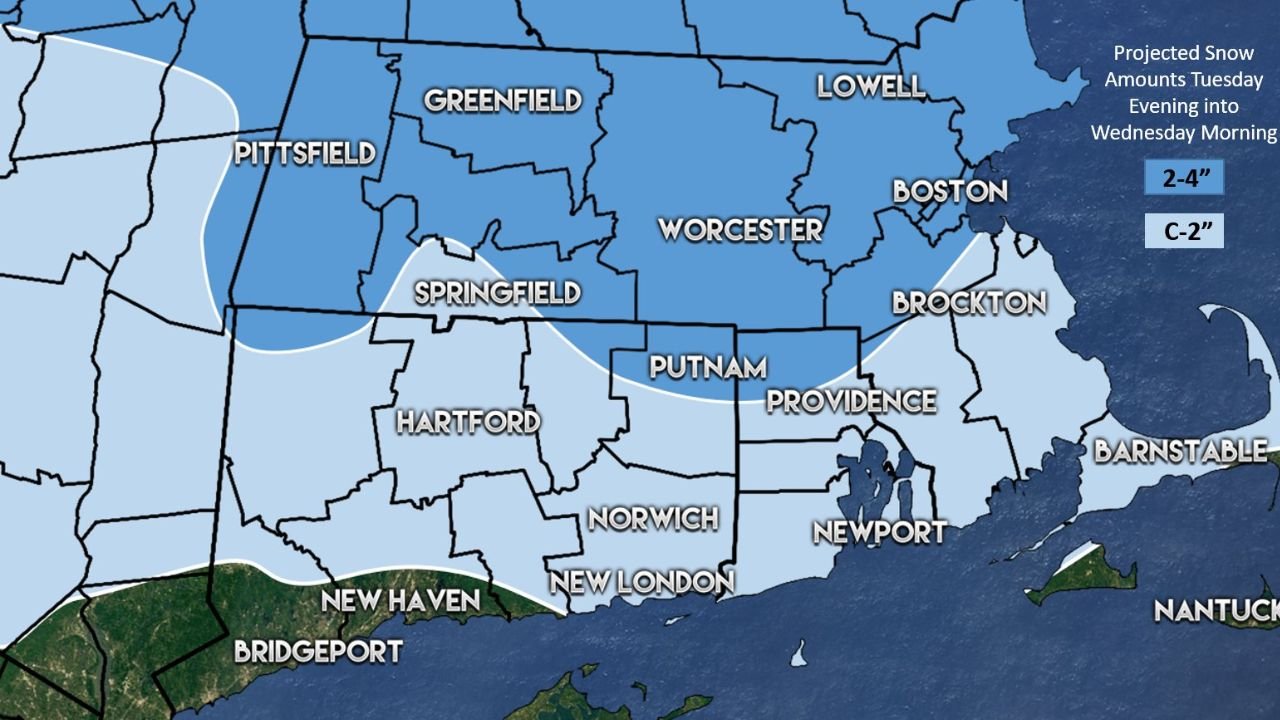
According to the latest snow map, the system will move quickly, limiting storm duration but still producing measurable snowfall across much of Massachusetts, northern Connecticut, and northern Rhode Island. Snow is expected to begin Tuesday evening and taper off by early Wednesday morning.
Higher Snow Totals Focused Inland and North
The highest snowfall amounts are projected across interior and northern sections of Southern New England, where colder air will support steadier accumulation. Areas including Worcester, Lowell, Greenfield, Pittsfield, Springfield, and parts of northern Massachusetts are forecast to see 2 to 4 inches of snow.
The snow band extends westward into western Massachusetts and parts of northern Connecticut, where accumulations remain solidly in the 2-inch range, especially away from the immediate coastline.
Boston and Urban Corridor See Lighter Accumulation
Along the Interstate 95 corridor, including Boston, Brockton, Providence, and nearby metro areas, snowfall totals are expected to be lower. The map indicates coating to 2 inches for these locations, with snowfall rates lighter and more intermittent.
Road conditions could still become slick for a time Tuesday night, particularly during the evening and early overnight hours.
Mixing and Rain Possible Along the South Coast and Cape
Farther south, warmer air closer to the ocean will limit snow accumulation. A brief period of snow may transition to a mix or even rain for southern coastal Massachusetts, Cape Cod, and the Islands, including Barnstable, Newport, and Nantucket.
These areas are expected to see little accumulation, with precipitation changing types as the system moves through.
Timing and Impacts
- Onset: Late Tuesday evening
- Peak: Tuesday night
- End: Very early Wednesday morning
Because the system is fast-moving, impacts should be relatively short-lived. However, untreated roads could become slippery overnight, especially in inland and northern locations where snowfall rates may briefly increase.
Monitoring Continues
Forecasters are continuing to monitor the track and thermal profiles of this clipper, as small shifts could influence snowfall totals — particularly near the rain-snow transition zone along the coast.
Stay with WaldronNews.com for updates as the system approaches and snowfall forecasts are refined.