
Feb 22–23 Nor’easter Blizzard Warning: New Jersey, New York, Long Island and Massachusetts Bracing for 16–24+ Inches as Snow Bands Intensify Toward Boston
NORTHEAST UNITED STATES — An intensifying late-February Nor’easter is now entering its final forecast phase, with updated snowfall projections increasing dramatically across New Jersey, New York City, Long Island, and parts of Southern New England — including Boston.
Forecasters have pushed totals to the upper end of guidance, warning that a major blizzard will rapidly worsen conditions beginning today and continuing through Sunday into early Monday.
This is the final forecast call before impact.
24+ Inches Possible Across Parts of New Jersey, Long Island and Coastal Massachusetts
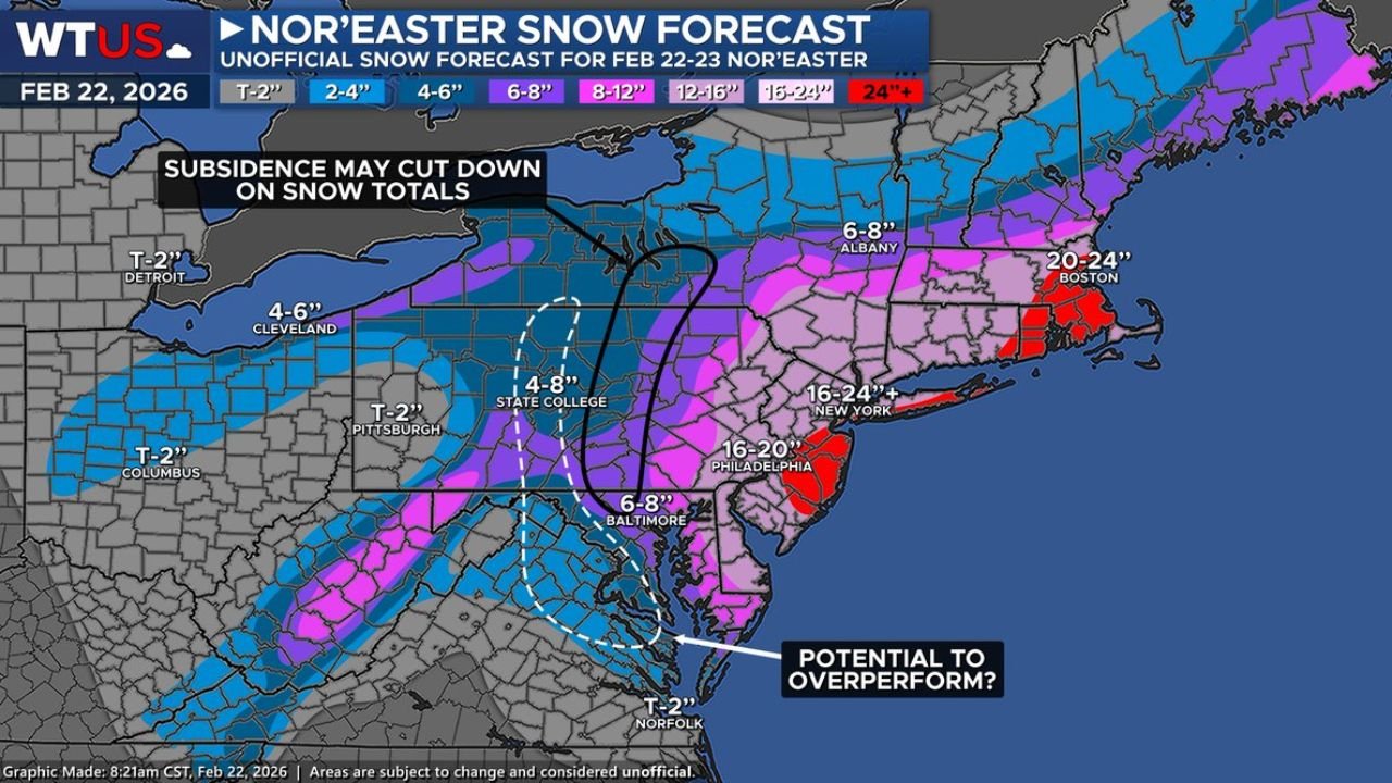
Updated snowfall projections now indicate localized totals exceeding 24 inches in:
- Central and eastern New Jersey
- New York City and portions of Long Island
- Coastal Connecticut and Rhode Island
- Eastern Massachusetts, including areas near Boston
Boston is forecast to receive 20–24 inches, while parts of eastern Massachusetts could locally exceed that mark if intense banding persists.
New York City sits in the 16–24+ inch zone, with Long Island also positioned in the highest impact corridor.
Philadelphia is projected to receive 16–20 inches, marking a significant winter event for southeastern Pennsylvania and southern New Jersey.
Heavy Snow Corridor Extends Southwest Through Pennsylvania and Maryland
A pronounced snow band stretches southwest from New England through:
- Albany, New York (6–8 inches)
- Central Pennsylvania, including State College (4–8 inches)
- Baltimore, Maryland (6–8 inches)
Washington, D.C. and surrounding areas are positioned in the 6–8 inch range, though localized enhancement remains possible if banding shifts slightly.
Farther west, totals drop off sharply:
- Cleveland: 4–6 inches
- Pittsburgh: Coating to 2 inches
- Columbus and Detroit: Trace to 2 inches
This sharp snowfall gradient highlights the storm’s tight deformation axis and how minor shifts could dramatically change totals over short distances.
Subsidence Zone May Limit Snow in Parts of Upstate New York
Forecasters are also monitoring a subsidence region — an area of sinking air that can reduce snowfall totals — across parts of western and central New York.
If that dry slot becomes established, snowfall in that corridor could underperform compared to surrounding regions.
However, just east of that zone, strong lift and moisture transport are expected to create intense snow bands capable of producing rapid accumulation rates.
Potential for “Overperformance” Along the I-95 Corridor
Meteorologists have flagged a corridor from coastal New Jersey through Long Island and into southeastern New England as an area with potential to overperform forecast expectations.
If mesoscale banding locks into place for several hours, snowfall rates could exceed 2 inches per hour in the heaviest bands, pushing some communities beyond the already aggressive 24-inch projections.
This would especially impact:
- Newark
- New York City
- Bridgeport
- Providence
- Boston
Localized blizzard conditions, including whiteout visibility and strong winds, are likely during peak snowfall.
Timing and Impacts
The storm is expected to strengthen rapidly today, with conditions deteriorating through the afternoon and evening.
Peak impacts are expected:
- Late Saturday into early Sunday
- Continuing into early Monday morning in parts of New England
Major travel disruptions are anticipated along:
- I-95 from Washington, D.C. to Boston
- I-78 and I-80 across New Jersey and Pennsylvania
- I-90 through upstate New York and Massachusetts
Airports in New York, Newark, Philadelphia, and Boston are likely to experience delays or cancellations.
Power outages are also possible in coastal areas where heavy, wet snow combines with gusty winds.
Final Outlook
This Nor’easter is shaping up to be a high-impact, potentially historic snowstorm for parts of the Northeast.
With snowfall projections now reaching 16–24+ inches in major metropolitan areas and isolated 24-inch-plus totals possible, residents from New Jersey to Massachusetts should prepare for dangerous winter conditions.
While some areas may see slightly lower totals due to subsidence, others may overperform dramatically if intense snow bands persist.
Stay with WaldronNews.com for continuing coverage as this major winter storm unfolds.