
February 14 Winter Storm Signal Strengthens as Models Turn Colder Under Northeast Blocking Pattern
UNITED STATES — The Feb. 14 target period is starting to come into clearer focus, and the newest guidance is sending a message winter-weather fans (and weekend travelers) know well: the pattern is becoming more favorable for a colder, more wintry outcome across parts of the Northeast and Mid-Atlantic. As forecast models get a better handle on a blocking setup, they’re increasingly showing energy getting forced underneath the block, then redeveloping into a more organized storm track.
The big picture takeaway from the latest maps: winter is far from over in the Northeast, and the Valentine’s weekend window is one to watch.
Why the forecast is changing: the “block” is becoming clearer
In the newest outlook, models appear to be responding to a better-defined blocking pattern in the broader hemispheric setup. When a block strengthens, it can slow down the flow and force storm energy to take a different route than it otherwise would.
That matters because blocks can:
- Keep cold air locked in longer on the north side of storms
- Push storm tracks to slide under the block instead of cutting north/west
- Increase the chance of redevelopment, which can intensify precipitation bands
- Raise the odds of snow and ice for places that would otherwise be rain
In short: as the block becomes better resolved, models are adjusting colder—and that’s often when snow/ice threats become more believable within this time range.
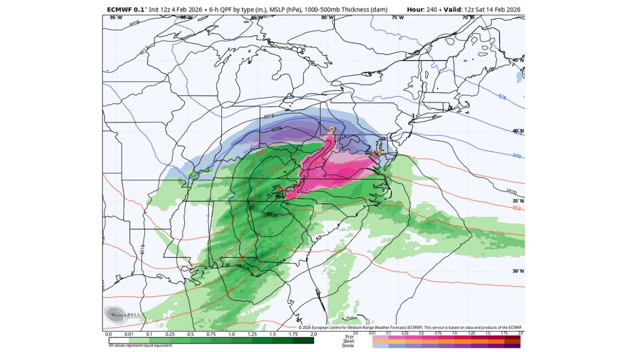
What the Feb. 14 model snapshot is showing right now
The precipitation-type view for Saturday, Feb. 14 shows a broad storm shield stretching from the Ohio Valley into the Mid-Atlantic and toward the northern Mid-Atlantic/Northeast corridor, with multiple precipitation types possible depending on where the cold air holds firm.
From what’s depicted:
- Rain is favored farther south and southeast in the warm sector
- A mix zone (freezing rain/sleet potential) is possible near the transition boundary
- Snow becomes increasingly likely north and northwest of the storm track where cold air is entrenched
This is the classic setup where the “line” matters—because a 50–100 mile shift can change a forecast from wet roads to significant winter travel impacts.
The highest-impact corridor to monitor
Based on the current storm depiction and typical block-driven setups, the corridor that tends to get the most complicated includes:
- Ohio, Indiana, and Kentucky (where the storm organizes and pushes east)
- West Virginia and Pennsylvania (often near the snow/mix gradient)
- Maryland and Virginia (where cold air timing decides rain vs. ice vs. wet snow)
- New Jersey and New York (where redevelopment can strengthen bands and pull colder air in faster)
It’s still early enough that exact placement will shift, but if the block remains strong, the storm may have a better chance to hold colder air in place longer than a typical February system.
What could go wrong: the snow/ice line is still the wildcard
Even with colder trends, the forecast is not “locked.” The biggest uncertainty for this type of storm is almost always:
- How quickly warm air tries to push north
- Whether surface cold air holds firm
- Where the redevelopment occurs
- How fast the storm intensifies once it redevelops
That’s how you can end up with very different outcomes across neighboring states:
- One area gets a cold rain
- Another gets a sleet/freezing rain mess
- Another ends up with accumulating snow and reduced visibility
What this could mean for Valentine’s weekend travel
Because the target period is Saturday, Feb. 14, this storm window falls right in the middle of a weekend when many people are on the roads.
If the colder trend continues, the main travel concerns would be:
- Icy patches where freezing rain or sleet develops
- Rapidly changing road conditions near the transition zone
- Reduced visibility if snow bands strengthen during redevelopment
- Slower plow response if heavier snow sets up in narrow corridors
If you have plans that involve highways or longer drives, the smartest move is to keep flexibility—because the biggest impacts can come down to where the storm sets up and how quickly cold air locks in.
The bottom line: winter’s pattern is still active
The pattern shown in the longer-range setup supports the idea that cold air can reload, and blocking can keep storm threats alive even after brief warmer breaks. The Feb. 14 target period is now entering a range where details will sharpen quickly—and the direction right now is colder, not warmer.
We’ll keep tracking where the storm develops, where the snow/ice line sets up, and whether the colder trend holds. If you’re in the Northeast or Mid-Atlantic, check back for updated timing and state-by-state impact zones on WaldronNews.com—and share what you’re seeing in your area as the forecast tightens.