
February 23 Coastal Storm Threat Builds for Maryland, Virginia, New Jersey and New York as Track Uncertainty Leaves Snow Forecast in Flux
MARYLAND — A developing Sunday–Monday storm system for February 23 is creating growing concern across the Mid-Atlantic and Northeast, with new model guidance showing dramatically different outcomes depending on how close the low-pressure center tracks to the coast.
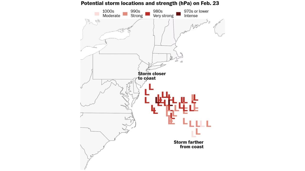
Ensemble projections reveal a cluster of possible storm positions offshore, with central pressures ranging from the 1000s millibars (moderate systems) down into the 970s or lower (intense systems). That difference in strength and placement could determine whether major cities see heavy snow, a rain-snow mix, or very little impact at all.
Three Possible Storm Track Scenarios Emerging
Forecast analysis outlines three distinct scenarios, each tied to the storm’s eventual position relative to the coastline.
Scenario 1: Storm Tracks Close to the Coast — High-Impact Snow Potential
In the most impactful setup, the storm forms and strengthens close enough to the shoreline of Virginia, Maryland, Delaware, New Jersey, and southern New York to bring widespread heavy snow and strong winds.
This solution features several model members deepening into the 980s and even 970s millibar range, signaling a potentially powerful coastal storm.
If this scenario verifies:
- Washington, D.C. and Baltimore could see significant snowfall.
- Philadelphia and southern New Jersey may experience heavy snow bands.
- New York City and Long Island could face accumulating snow and gusty coastal winds.
- Interior areas would likely remain all snow with higher totals.
A closer coastal track would allow colder air to remain locked in across the region, maximizing snowfall potential.
Scenario 2: Middle-of-the-Road Track — Mixed Precipitation
The second scenario places the storm slightly farther offshore but still close enough to brush the coastline.
Under this outcome:
- Coastal communities could see a mix of rain and snow.
- Snow totals would be lighter and more variable.
- Interior sections of Pennsylvania, upstate New York, and inland New England would have a better chance at steadier snow.
This solution limits the most extreme impacts but still produces travel concerns and periods of wintry weather.
Scenario 3: Storm Develops Farther Offshore — Minimal Impacts
The least disruptive scenario keeps the storm center well out in the Atlantic.
In this case:
- The heaviest snow and strongest winds remain offshore.
- Only light precipitation reaches parts of the coast.
- Major metropolitan areas avoid significant accumulations.
Several lighter-colored low placements in the ensemble guidance support this offshore solution, showing weaker systems that never consolidate close enough to bring widespread impacts.
Why a Small Shift Makes a Big Difference
Even a shift of 50 to 100 miles in the storm’s path could dramatically alter conditions across densely populated corridors.
A closer track increases:
- Cold air entrenchment
- Snowfall intensity
- Wind potential
- Coastal impacts
A farther offshore solution pulls the strongest dynamics away from land, sharply reducing snowfall totals.
Storm strength also matters. A system deepening into the 970s millibar range would support stronger winds and heavier precipitation bands compared to a weaker 1000–990 millibar system.
Timing and Next Forecast Updates
The system is expected to organize late Sunday into Monday, February 23, with model clarity improving over the next 24–48 hours.
Forecasters are expected to issue more detailed, region-specific updates — especially for the D.C. metro area and the I-95 corridor — by midday or early afternoon as new model data becomes available.
What Residents Should Do Now
While confidence is growing that a storm will form offshore, the exact track remains uncertain.
Residents across:
- Maryland
- Virginia
- Delaware
- New Jersey
- New York
- Pennsylvania
- New England
should monitor updated forecasts closely as small shifts could determine whether this becomes a significant winter storm or a near miss.
WaldronNews.com will continue providing updates as new data refines the February 23 storm outlook.