
First Call Snow Map Shows 6–12+ Inches From Philadelphia to New York and 12+ Near Boston, But NYC Range Swings From 2–5 to 8–12+
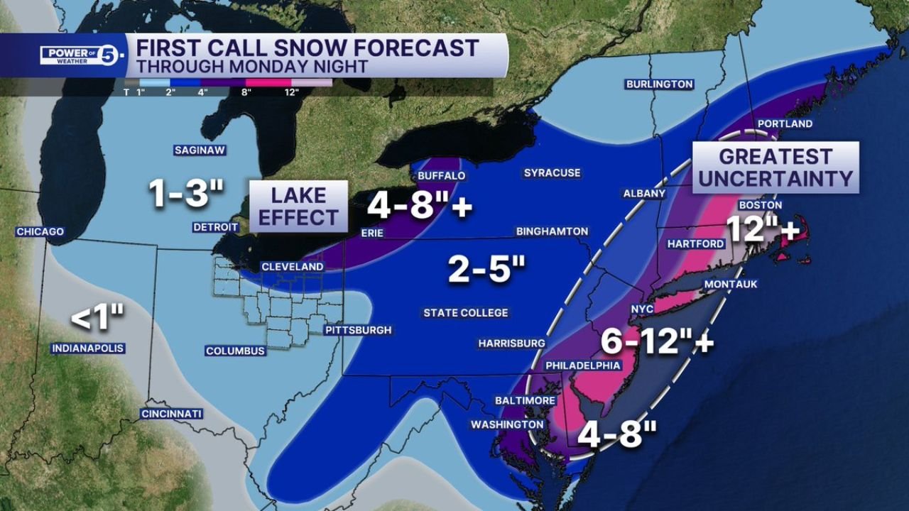
MID-ATLANTIC AND NORTHEAST — The first-call snow forecast for the Sunday–Monday system is out, and while impactful snowfall is increasingly likely somewhere along the East Coast, uncertainty remains high — especially for New York City and southern New England.
With roughly 48 hours until onset, multiple pieces of upper-level energy are expected to “phase” into one consolidated coastal storm. How quickly that phasing occurs — and exactly where the storm strengthens — will determine who sees moderate snow and who ends up in blizzard conditions.
Mid-Atlantic: 4–8 Inches From D.C. to Baltimore, 6–12+ Near Philadelphia
The current projection through Monday night calls for:
- Washington, D.C.: 4–8 inches
- Baltimore: 4–8 inches
- Philadelphia: 6–12+ inches
The heaviest snow in the Mid-Atlantic corridor is shown favoring southeastern Pennsylvania into southern New Jersey. A stronger coastal track would increase totals closer to the 12-inch range near and just east of I-95.
Farther west, including parts of Pittsburgh and central Pennsylvania, totals drop into the 2–5 inch range.
New York City: Greatest Uncertainty Zone
Perhaps the most volatile forecast lies in New York City, where snowfall projections could swing dramatically depending on the storm’s track and speed of intensification.
Current possibilities range from:
- 2–5 inches in a weaker or slightly offshore solution
- 8–12+ inches if the coastal low tracks closer and strengthens rapidly
NYC sits near the sharp gradient between moderate and heavy snow. A shift of even 50 miles could make the difference between a manageable snowfall and a high-impact winter storm.
Southern New England: 12+ Inches Possible Near Boston
The forecast map shows the strongest signal for significant snowfall in parts of eastern Massachusetts, including Boston, where totals of 12 inches or more are possible under a stronger scenario.
Areas including Hartford and much of Connecticut fall in the 6–12+ inch range, with potential for higher amounts if mesoscale banding develops.
Farther north into Maine, lighter to moderate accumulations are indicated, though localized heavier totals are possible depending on storm evolution.
Lake Effect Adds to Western Impacts
Behind the primary coastal storm, lake effect snow bands are expected to develop downwind of Lake Erie, with 4–8+ inches possible in favored areas near Buffalo and Erie.
Elsewhere in the Midwest, including Chicago and Indianapolis, snowfall is expected to remain light — generally under 1–3 inches.
Why Track and Phasing Matter
The key forecast challenge remains the interaction of multiple energy pieces in the upper atmosphere. If they phase quickly and consolidate into a stronger coastal low, snowfall totals along I-95 will trend higher.
If phasing is delayed or the low tracks farther offshore:
- Heaviest snow shifts east
- Inland totals drop
- NYC could fall on the lower end of projections
Forecasters emphasize that the “exact track and speed of intensification will have huge impacts” on both the lake effect zone and the I-95 corridor.
Bottom Line
Impacts are increasingly likely from Washington, D.C. through Philadelphia, New York City, Hartford, and Boston, but exact snowfall amounts remain highly sensitive to storm evolution.
Residents across the Mid-Atlantic and Northeast should monitor updates closely over the next 24–36 hours as confidence increases and the heavy snow axis becomes clearer.
Stay with Waldronnews.com for continued updates as this high-impact winter storm takes shape.