
Florida and Gulf Coast Face Growing March Wildfire Threat as Rainfall Deficits Deepen Across Alabama, Georgia, Louisiana and Mississippi
FLORIDA AND THE GULF COAST — Lingering La Niña conditions continue to suppress rainfall across the Deep South, and new extended model guidance shows significantly below-normal precipitation persisting through late March — a trend that could sharply elevate wildfire risk across Florida and Gulf Coast states.
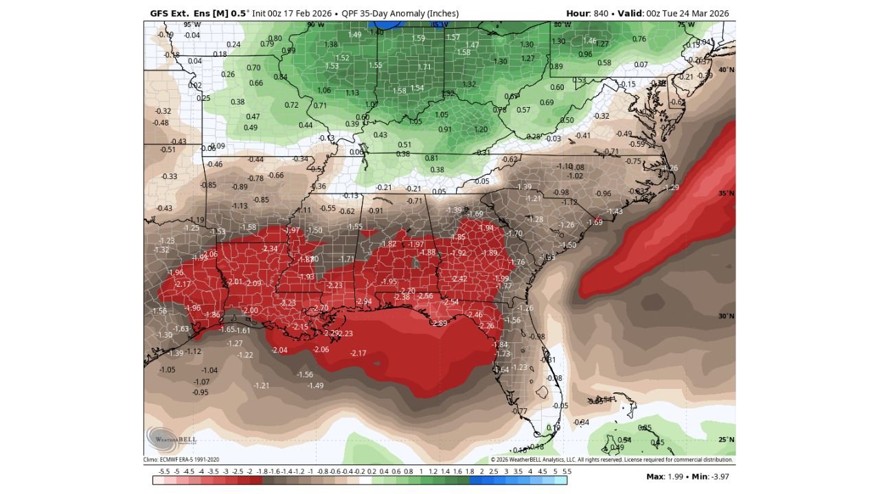
The latest 35-day precipitation anomaly outlook highlights widespread negative rainfall departures stretching from Louisiana and Mississippi through Alabama and Georgia, into much of Florida.
Rainfall Deficits Worsening Across the Southeast
The ensemble mean projection through March 24 shows:
- Louisiana and southern Mississippi: 2 to 3 inches below normal.
- Southern Alabama and southwest Georgia: 1.5 to 2.5 inches below average.
- North Florida and the Florida Panhandle: 1 to 2 inches below normal.
- Portions of central Florida also trending drier than average.
The deepest deficits appear centered along the central Gulf Coast and coastal Louisiana, where anomalies exceed -2.5 inches in some areas.
Meanwhile, areas farther north across the Midwest and Ohio Valley are projected to remain wetter than normal, underscoring a sharp north–south moisture divide.
Florida Already Behind on Rainfall Since Fall
Some locations in Florida are reportedly 5 to 10 inches below normal rainfall since last fall, meaning soils are already dry heading into peak spring fire season.
Compounding the problem:
- Recent cold snaps have killed or dried vegetation.
- Dry brush and dormant fuels have accumulated.
- Extended dry periods are allowing fuels to cure more rapidly.
Without a meaningful shift in the pattern, these conditions could set the stage for an active wildfire month in March.
La Niña Influence Still in Play
La Niña typically favors:
- A more active northern storm track.
- Suppressed rainfall across the southern tier of the U.S.
- Drier conditions across Florida and the Gulf Coast during late winter and early spring.
The latest anomaly map suggests that pattern is persisting, with much of:
- Louisiana
- Mississippi
- Alabama
- Georgia
- Florida
remaining locked into below-average precipitation through mid to late March.
Why March Is Critical
March often marks a transitional month where:
- Temperatures begin to warm.
- Winds can increase during frontal passages.
- Vegetation becomes more vulnerable to ignition.
If dry conditions continue, even routine brush fires could spread more quickly.
Coastal and inland portions of Florida may be especially vulnerable given existing rainfall deficits and fuel buildup.
Areas Most at Risk
Based on projected rainfall anomalies and current dryness, the highest wildfire concern appears focused on:
- Florida Peninsula
- Florida Panhandle
- Southern Alabama
- Southern Mississippi
- Southern Louisiana
- Parts of southwest Georgia
Emergency management agencies in these regions may begin increasing fire weather monitoring as March progresses.
Bottom Line
Extended guidance continues to signal significantly below-normal rainfall across Florida and the Gulf Coast through late March, reinforcing concerns that wildfire risk could escalate if conditions do not change.
With La Niña’s influence still evident and rainfall deficits already mounting, March could become a critical month for fire potential across the Southeast.
WaldronNews.com will continue tracking rainfall trends and fire weather outlooks as the pattern evolves.