
Florida Braces for Rare Backdoor Cold Front as 50 MPH Winds Target Tampa, Orlando, Daytona Beach Saturday Afternoon
FLORIDA — An unusually strong and rare backdoor cold front is expected to sweep across central and northern Florida Saturday afternoon, bringing powerful northeast wind gusts of 40 to 50 mph and a sharp shift in weather conditions across the region.
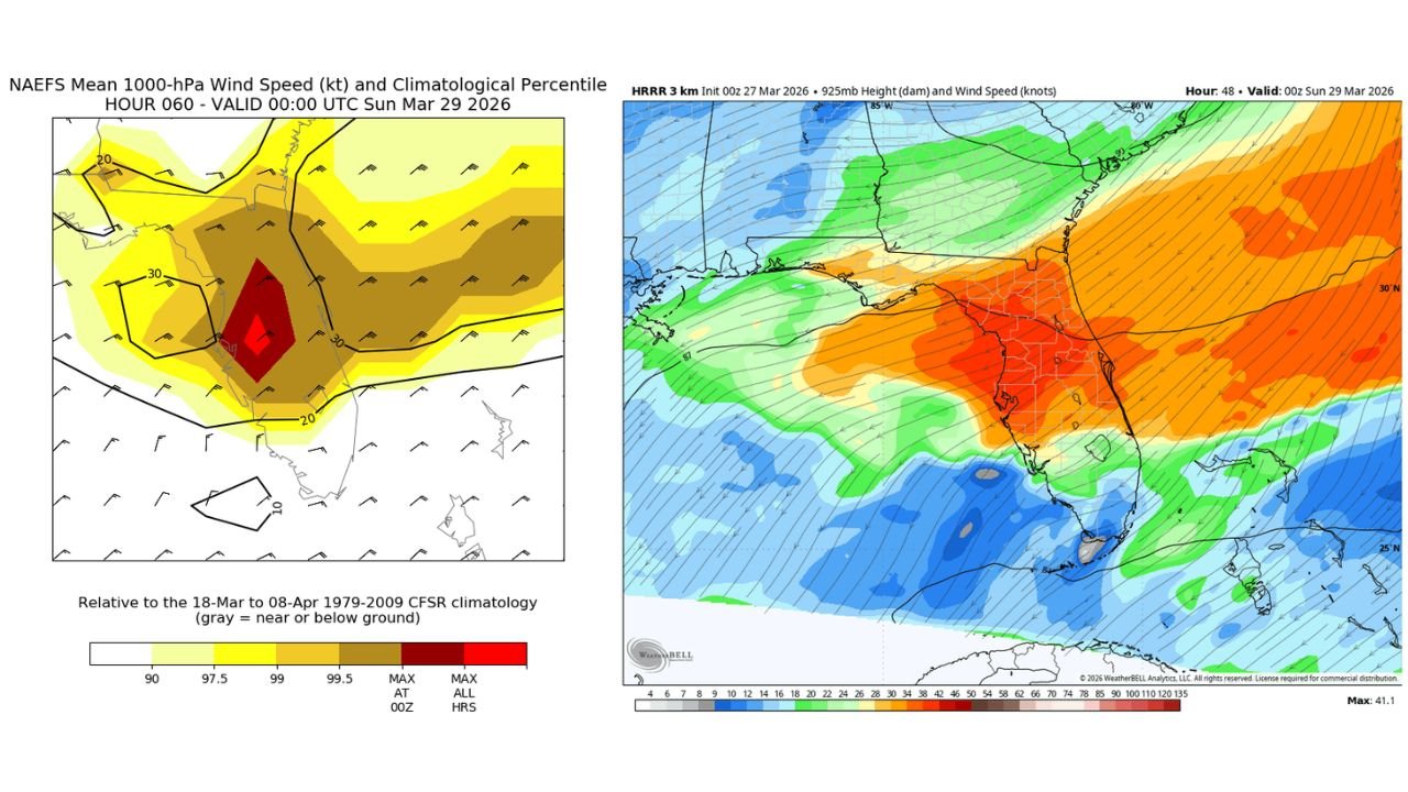
Forecast data highlights this event as particularly notable for late March, with near-record wind speeds at the 1000mb level signaling an intense surge of air pushing into the state from the northeast.
Strongest Winds Target Central and North Florida
The core of the wind event is expected to impact major population centers across central Florida, including:
- Tampa
- Orlando
- Daytona Beach
These areas could experience sustained strong winds with gusts reaching 40–50 mph for several hours, especially during the peak of the frontal passage Saturday afternoon.
Wind fields shown in forecast guidance indicate a concentrated zone of higher wind speeds spreading across much of the Florida Peninsula, with the strongest core centered over central sections of the state.
What Makes This Event Unusual
Backdoor cold fronts — systems that move in from the northeast rather than the typical west or northwest — are relatively uncommon in Florida, especially with this level of intensity.
Even more notable is the strength of the low-level winds, which are approaching record levels for this time of year. Such strong winds are rarely observed in late March, making this event stand out meteorologically.
Rapid Change in Conditions Expected
As the front moves through, residents can expect:
- A quick increase in wind speeds
- Shifting wind direction from typical patterns to strong northeast flow
- Increasing cloud cover and potentially cooler conditions following frontal passage
The abrupt nature of the change could catch some residents off guard, especially after calmer conditions leading up to the event.
Potential Impacts Across the Region
While this system is not primarily associated with severe thunderstorms, the strong winds alone could lead to impacts such as:
- Downed tree limbs and minor structural damage
- Difficult driving conditions, particularly for high-profile vehicles
- Rough conditions along coastal areas and waterways
Boaters and beachgoers may experience hazardous marine conditions due to strong onshore winds.
A Notable Late-March Wind Event
The combination of a backdoor cold front and near-record low-level wind speeds makes this a highly unusual late-season event for Florida.
Events of this nature highlight how rapidly weather patterns can shift, even in typically stable spring conditions across the state.
What to Watch Next
As Saturday approaches, updates will refine:
- Exact timing of peak wind gusts
- Duration of strongest winds
- Areas most likely to experience impacts
Residents across central and northern Florida should stay alert and prepare for a period of unusually strong winds.
Waldron News will continue tracking this developing system and provide updates as conditions evolve across Florida.