Florida Coastal Waters Turn Unusually Cold After Arctic Blasts, With Near-Record Sea Surface Cooling in the Gulf and Atlantic

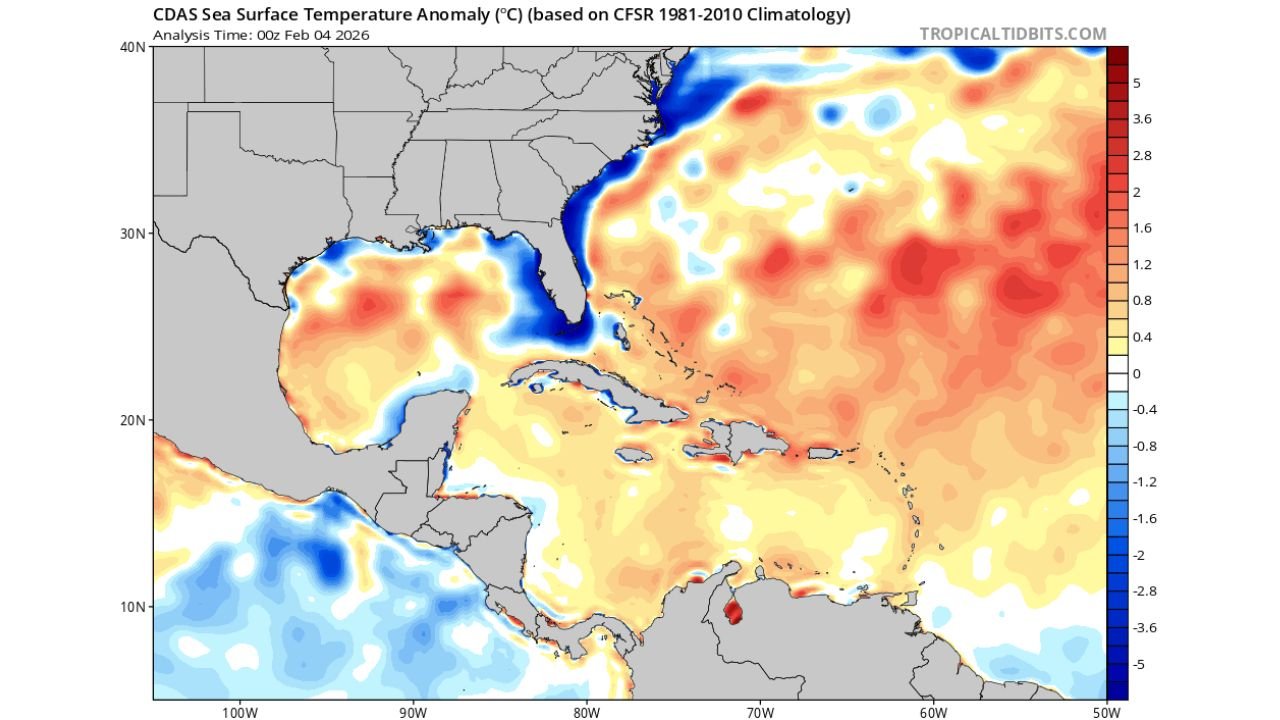
UNITED STATES — After a series of intense Arctic air outbreaks, new sea surface temperature anomaly data shows unusually cold ocean waters developing along Florida’s coastline, with pockets of water measuring nearly 5°C (about 9°F) below normal. The cooling is concentrated along Florida’s Atlantic coast, the eastern Gulf of Mexico, and waters surrounding the Florida Peninsula, driven by persistent northerly winds and repeated cold-air intrusions.
Cold Air Outbreaks Leave a Mark on Florida Waters
Recent record-setting cold air masses pushing deep into the Southeast have not only affected land temperatures but have also dramatically cooled shallow coastal waters around Florida. According to the anomaly maps, large sections of nearshore waters are now well below climatological averages, an uncommon pattern for early February in this region.
The coldest anomalies are observed close to shore, where shallow waters respond more rapidly to sustained cold air and strong wind-driven mixing. Offshore waters remain closer to seasonal norms, highlighting how wind exposure and water depth are playing a major role in the cooling process.
Near −5°C Anomalies Along Florida’s Coastline
The most striking feature in the data is the appearance of localized pockets near −5°C, or roughly 9°F colder than normal, especially along Florida’s Atlantic coastline and portions of the eastern Gulf. These anomalies reflect persistent northerly winds, which have repeatedly transported cold continental air over warm-season waters.
This process accelerates heat loss from the ocean surface, allowing colder subsurface water to mix upward while preventing rapid recovery between cold fronts. As a result, sea surface temperatures have lagged well behind typical early-February conditions.
Why Persistent Northerly Winds Matter
Unlike short-lived cold snaps, the current pattern has featured repeated cold air surges with limited warm recovery time in between. Northerly winds enhance cooling by:
- Increasing evaporation at the ocean surface
- Promoting vertical mixing in shallow coastal waters
- Preventing warm Gulf and Atlantic waters from reestablishing nearshore
This combination has allowed cold anomalies to persist longer than usual, especially along Florida’s coastline where water depths are shallower.
Potential Impacts of Colder Coastal Waters
Colder-than-normal sea surface temperatures can have several downstream effects, including:
- Reduced evaporation and moisture availability for nearby weather systems
- Stress on marine ecosystems sensitive to rapid temperature changes
- Temporary suppression of typical warm, humid coastal conditions
While no immediate hazards are indicated, continued monitoring is important, especially if additional cold air outbreaks reinforce the pattern.
What Happens Next Depends on the Pattern Shift
Whether these cold anomalies persist will depend on how quickly the broader weather pattern relaxes. A sustained return to southerly flow and warmer air would allow surface waters to gradually recover, but continued northerly winds could maintain below-normal temperatures well into mid-February.
For now, the data confirms that Florida’s coastal waters are experiencing one of the more notable early-February cold anomalies in recent years, directly tied to repeated Arctic intrusions.
Stay connected with WaldronNews.com for continued updates on unusual weather patterns, temperature anomalies, and developing impacts across the United States. If you’ve noticed changes along the coast or have local observations to share, join the conversation and follow our latest reports at WaldronNews.com.
