
Florida East Coast Rain Alert Issued for Miami, West Palm Beach, Orlando and Jacksonville as Heavy Downpours Raise Flood Concerns This Week
FLORIDA — A prolonged stretch of heavy rainfall is now expected to impact much of the Florida Peninsula this week, with the highest concern focused along the east coast, where repeated downpours could lead to localized flooding issues.
This setup is being driven by a persistent moisture-rich pattern, bringing multiple days of rain chances across cities including Miami, West Palm Beach, Port St. Lucie, Orlando, Daytona Beach, and Jacksonville.
Heavy Rain Focused Along Florida’s East Coast
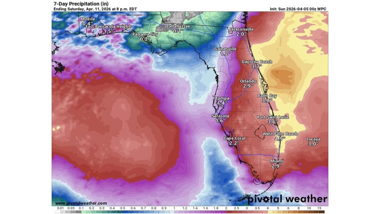
Forecast data shows a clear signal for significant rainfall totals along the Atlantic side of Florida, where moisture will be most concentrated.
- West Palm Beach: around 4 to 5 inches possible
- Port St. Lucie: around 3 to 4 inches
- Daytona Beach: near 3 to 4 inches
- Orlando: around 2 to 3 inches
- Miami: around 2 to 3 inches
- Jacksonville: near 2 inches
These totals will not fall all at once, but rather through repeated rounds of showers and storms throughout the week, increasing the risk of water buildup.
Flooding Risk Increasing in Urban Areas
With rain falling over multiple days, urban flooding becomes a growing concern, especially in densely populated regions.
- Streets and low-lying areas in Miami, Fort Lauderdale, and West Palm Beach may see ponding or temporary flooding
- Drainage systems could become overwhelmed during heavier bursts of rain
- Coastal and metro corridors are most vulnerable due to impervious surfaces and limited runoff capacity
Even moderate rainfall rates can quickly create issues when storms repeatedly track over the same locations.
Rain Brings Some Relief — But Not Everywhere
While this system will deliver beneficial rainfall in some areas, it may not fully address drought concerns:
- Portions of Florida will see temporary drought relief
- However, areas that need rain the most may miss the heaviest totals
- Rain distribution is expected to be uneven across the state
This means some regions could see excess water, while others receive only limited benefit.
Broader U.S. Pattern Also Highlights Florida Risk
National outlook data further supports the Florida focus:
- A designated heavy rain zone is highlighted across the Florida Peninsula
- Additional heavy rain areas appear across parts of the Southern Plains and Midwest, but Florida remains a key concern
- Timing suggests the most active rainfall period will occur during the mid-to-late work week
What to Expect Day-to-Day
Residents can expect:
- Periods of scattered to widespread showers and thunderstorms
- Occasional heavier downpours capable of reducing visibility and causing quick water accumulation
- Breaks in between rounds, but no long-lasting dry period during the week
Rain chances will remain elevated for several consecutive days, especially along the east coast.
Final Outlook
Florida is entering a wet and potentially disruptive weather pattern, with the east coast corridor from Miami to Jacksonville facing the highest rainfall totals and localized flood risks.
While not a guaranteed widespread flooding event, the repeated nature of the rainfall makes this a situation residents should monitor closely throughout the week.
Stay with WaldronNews.com for continued updates as this developing Florida rain event evolves and more precise rainfall details become available.