
Florida Facing Worst Drought Since 2001 as Tampa, Bradenton, Sarasota and Fort Myers Run 8 to 12 Inches Behind on Rainfall
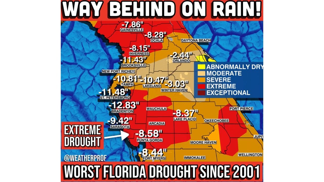
FLORIDA — Much of the Sunshine State is now entrenched in what experts are calling the worst drought in 25 years, with rainfall deficits stretching back to September 1 reaching staggering levels across central and western Florida.
New data shows parts of the state are a full foot behind on rainfall, marking the driest comparable stretch on record for many communities. While a potential inch of rain may fall Sunday night, forecasters say it would barely dent what has become a rapidly worsening water crisis heading into peak fire season.
Tampa Bay Region Among Hardest Hit
The most alarming rainfall deficits are centered along Florida’s Gulf Coast and interior central counties.
Current rainfall shortages include:
- Bradenton: -12.83 inches
- St. Petersburg: -11.48 inches
- Brooksville: -11.43 inches
- Tampa: -10.81 inches
- Lakeland: -10.47 inches
- Sarasota: -9.42 inches
- Punta Gorda: -8.58 inches
- Fort Myers: -8.44 inches
These deficits reflect rainfall totals since early September and underscore just how dramatically below normal the region has been for months.
Extreme and Exceptional Drought Expanding
Drought classification data shows large swaths of central and southwest Florida in Extreme Drought (red), with pockets approaching or reaching Exceptional Drought levels in some zones.
Areas north and inland, including:
- Gainesville: -7.86 inches
- Ocala: -8.28 inches
- Inverness: -8.15 inches
are also well behind normal rainfall levels.
Meanwhile, Orlando shows a smaller but still notable deficit of -2.44 inches, highlighting the uneven but widespread dryness across the peninsula.
Worst Since 2001
Meteorologists note this is the most severe statewide drought since 2001. The cumulative deficit since early fall has left soils dry, reservoirs stressed, and vegetation increasingly vulnerable.
The concern is not just about current dryness — it’s about timing.
Florida is now moving toward its spring fire season, when:
- Vegetation becomes more flammable
- Winds can increase wildfire spread
- Lightning from early-season storms can spark new fires
With rainfall so far below normal, wildfire risk could escalate quickly if dry conditions persist.
One Inch Won’t Fix It
Forecasters say there is potential for roughly an inch of rainfall Sunday night in parts of the state. While any rain is welcome, experts caution that:
- A single inch does not erase deficits of 8–12 inches
- Soil moisture recovery takes sustained rainfall
- Groundwater and reservoir levels lag behind short-term rain events
In short, the state would need repeated soaking systems to meaningfully reverse the drought.
Agricultural and Water Supply Concerns Growing
Prolonged dryness raises concerns for:
- Citrus and row crop farmers
- Livestock operations
- Municipal water systems
- Lawn irrigation restrictions
If rainfall remains below average into late spring, water conservation measures could become more widespread.
A Tough Spring Ahead
The data makes clear that Florida is entering a challenging stretch. With many communities already a foot behind on rainfall and only isolated short-term rain chances ahead, the state remains in a precarious position.
Unless a sustained wet pattern develops soon, Florida could see increasing wildfire activity and mounting stress on water resources through the heart of spring.
WaldronNews.com will continue tracking rainfall trends, drought classifications, and fire weather conditions across Florida in the weeks ahead.