
Florida, Georgia and Alabama Under Targeted Tornado Risk Sunday as Squall Line Pushes East From Gulf Coast
FLORIDA — A maturing squall line is expected to sweep east across the Gulf Coast on Sunday, bringing a targeted tornado risk to parts of Florida, southern Georgia and southeast Alabama between the morning and early evening hours. While forecasters stress this is not an outbreak setup, a few embedded circulations capable of producing isolated tornadoes cannot be ruled out.
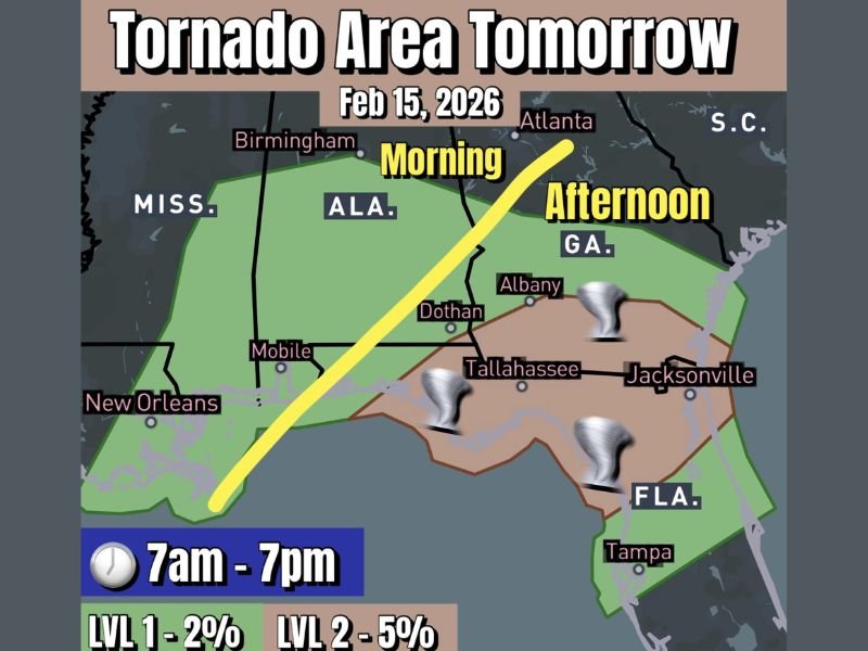
The primary window for concern stretches from 7 a.m. to 7 p.m., as the line of storms tracks from Louisiana and Mississippi overnight into Alabama in the morning, then into the Florida Panhandle and southern Georgia during the afternoon.
Where the Tornado Risk Is Highest
Forecast guidance highlights a Level 1 (2%) tornado risk across a broad swath of southern Alabama and much of Georgia, with a more focused Level 2 (5%) risk centered on:
- The Florida Panhandle, including Tallahassee
- Far southern Georgia, including Albany
- Portions of north Florida extending toward Jacksonville
Cities such as Mobile, Dothan, Tallahassee, Albany and Jacksonville sit within the corridor where brief tornadoes or rotating storm segments are most possible.
Meteorologists note that the line of storms may weaken somewhat during the morning, but re-intensification is possible as it approaches the Florida Panhandle by midday and early afternoon. Additional discrete cells could also form ahead of the main line, increasing localized risk.
Morning vs. Afternoon Timing
The severe threat will likely evolve in phases:
- Morning: Storms move through southern Alabama and the western Florida Panhandle. Embedded circulations within the squall line are possible.
- Afternoon: The line pushes into southern Georgia and north Florida. Atmospheric conditions may become slightly more favorable for brief tornado development.
- Early Evening: Storms continue east toward Jacksonville and possibly into parts of coastal Georgia before gradually weakening.
Forecasters emphasize that this setup does not favor long-track, violent tornadoes. Instead, the concern centers on short-lived spin-ups embedded within the line, which can develop quickly and offer limited warning time.
Not a Widespread Outbreak — But Stay Alert
While confidence remains low for a major severe weather outbreak, even a “handful of random circulations” can pose risks to homes, vehicles and outdoor activities.
Residents across Florida, Georgia and Alabama are encouraged to:
- Keep weather alerts enabled on mobile devices
- Identify a safe shelter location in advance
- Monitor updated forecasts throughout the day
Because squall-line tornadoes often develop rapidly, warnings may be issued with little lead time.
What Happens Next
Behind the system, conditions are expected to gradually improve, though gusty winds and lingering showers may continue into parts of Georgia and the Carolinas later in the day.
WaldronNews.com will continue to monitor forecast updates as new model guidance arrives and timing becomes more refined.
Stay weather-aware Sunday if you’re in Florida, southern Georgia or southeast Alabama, especially during the late morning and afternoon hours when the strongest storms are most likely.