
Florida Panhandle, Including Pensacola, Destin, Panama City, and Tallahassee, Faces Expanded Overnight Tornado Threat With Potential for Significant EF2+ Twisters
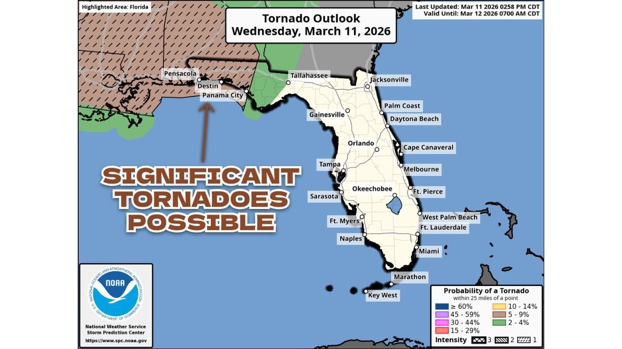
FLORIDA PANHANDLE — The tornado threat across northern Florida has intensified, with the latest outlook expanding the higher-risk corridor eastward toward Panama City and Tallahassee. Forecasters now warn that the potential exists not just for isolated tornadoes, but for significant tornadoes rated EF2 or stronger overnight into early Thursday morning.
The updated Tornado Outlook valid through early Thursday shows the greatest concern centered along the western and central Florida Panhandle, including:
- Pensacola
- Destin
- Panama City
- Tallahassee
The expansion eastward signals increasing confidence that stronger rotating storms could track farther into the Panhandle than previously anticipated.
Significant Tornadoes Possible
The outlook specifically highlights the potential for “significant tornadoes,” defined as EF2 or greater on the Enhanced Fujita scale. These tornadoes are capable of:
- Major structural damage
- Uprooted trees and snapped power poles
- Long-track paths under favorable storm conditions
The hatched risk area across the western Panhandle indicates concern for stronger tornado intensity potential, particularly near coastal communities from Pensacola eastward toward Panama City.
Timing: Overnight Through Early Morning
The greatest tornado risk window is expected overnight into the pre-dawn hours. Nighttime tornado threats are especially dangerous due to:
- Reduced visibility
- Sleeping residents
- Limited ability to visually confirm approaching storms
Storms are expected to move from west to east, pushing through the Panhandle before daybreak Thursday.
Areas Outside the Highest Risk
While the most significant concern is across the western and central Panhandle, a broader marginal tornado risk extends across parts of:
- North Florida
- Southern Georgia
Cities such as Gainesville and Jacksonville may see strong thunderstorms, though the highest tornado probabilities remain closer to the Panhandle coastline.
Central and South Florida, including Orlando, Tampa, Sarasota, Fort Myers, West Palm Beach, Fort Lauderdale, Miami, and the Florida Keys, are not currently highlighted in the higher tornado probability zones for this event.
Why the Risk Is Increasing
The eastward expansion toward Panama City and Tallahassee suggests atmospheric conditions are aligning more favorably for rotating storms. Strong wind shear combined with Gulf moisture and instability may support discrete supercells capable of producing tornadoes ahead of a larger squall line.
With coastal and inland Panhandle communities in the potential impact zone, residents should remain weather aware through the night.
Safety Reminders
Given the overnight timing, officials urge residents to:
- Enable emergency alerts on mobile devices
- Have multiple ways to receive warnings
- Identify a safe shelter location in advance
- Avoid relying solely on outdoor sirens
The evolving nature of this system means conditions could change quickly.
Stay with WaldronNews.com for continuous updates as this overnight tornado threat unfolds across the Florida Panhandle.