
Florida Rain Alert Issued for Orlando, Daytona Beach, Titusville and Space Coast as Flood Risk Builds Through Thursday
FLORIDA — A new rainfall alert has been issued across Central and East Florida, warning residents that multiple rounds of heavy rain and storms will continue through Thursday, with some areas now facing a serious flooding risk.
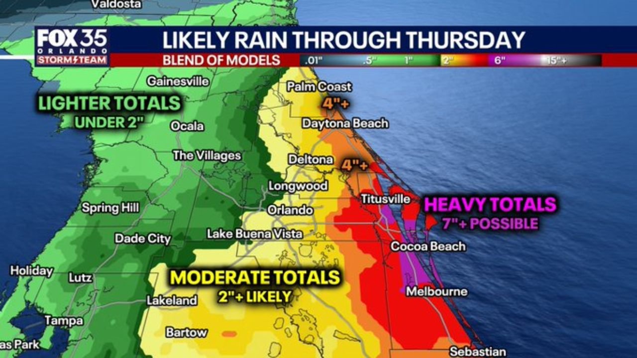
Forecast data shows a clear east-to-west rainfall gradient, meaning conditions will vary significantly depending on location — but the greatest concern is focused along the Atlantic side of the state.
Heavy Rain Zone Expands Along the East Coast
The latest projections highlight a high-impact rainfall corridor stretching from Orlando to the Space Coast, including:
- Daytona Beach
- Titusville
- Cocoa Beach
- Melbourne
- Palm Coast
These areas are now under the highest rainfall threat, where totals could exceed 7 inches in some locations.
This raises the risk of localized flooding, especially in low-lying and urban areas.
Central Florida Also Facing Significant Rainfall
Further inland, including:
- Orlando
- Deltona
- Longwood
- Lake Buena Vista
Residents can expect moderate to heavy rainfall totals around 2 to 4 inches, with periods of steady rain and embedded storms.
While not as extreme as coastal zones, these areas could still see ponding on roads and localized drainage issues.
West Florida Sees Lower Totals but Not Dry
Western parts of the peninsula, including:
- Tampa
- Spring Hill
- Ocala
- The Villages
are expected to receive lighter totals under 2 inches, but still face scattered showers and occasional storms.
Even in these areas, brief heavy downpours could occur, though flood risk remains lower compared to the east.
Peak Rainfall Timing Identified
The most active period for this event is expected to be:
- Tuesday through Wednesday → Highest and most widespread rainfall
- Continued rain chances through Thursday
This means the event is not just a single storm — but a multi-day rainfall setup, increasing the overall flood risk.
Why Flooding Risk Is Increasing
Several key factors are driving concern:
- Repeated storm development over the same areas
- Strong moisture flow into Central and East Florida
- Increasing rainfall totals with each model update
This combination creates a setup where rainfall can accumulate quickly over time, even if individual storms are not extreme.
Areas Most at Risk
The highest concern zone currently includes:
- Space Coast (Titusville, Cocoa Beach, Melbourne)
- Daytona Beach and Palm Coast region
- Eastern sections of Orlando metro
These areas could experience:
- Street flooding
- Water accumulation in poor drainage zones
- Rapid changes in conditions during heavy rainfall bursts
What Residents Should Expect
As this system continues through the week:
- Frequent rain and storm chances daily
- Periods of heavy rainfall capable of reducing visibility and travel safety
- Increasing potential for localized flooding in vulnerable areas
The east coast in particular should remain on alert for rapidly changing conditions.
Situation Continues to Evolve
With rainfall totals trending higher and the flood-prone zone expanding inland, this is a situation that requires close monitoring across Florida.
The combination of multi-day rainfall, high totals, and repeated storm activity makes this one of the more impactful rain events of the week.
Stay with WaldronNews.com for continued updates as this Florida rain and flooding threat develops through Thursday.