
Florida Rain Alert Miami, Orlando, Tampa and Jacksonville Set for Widespread 2 to 4 Inches as Stalled Front Targets Peninsula This Week
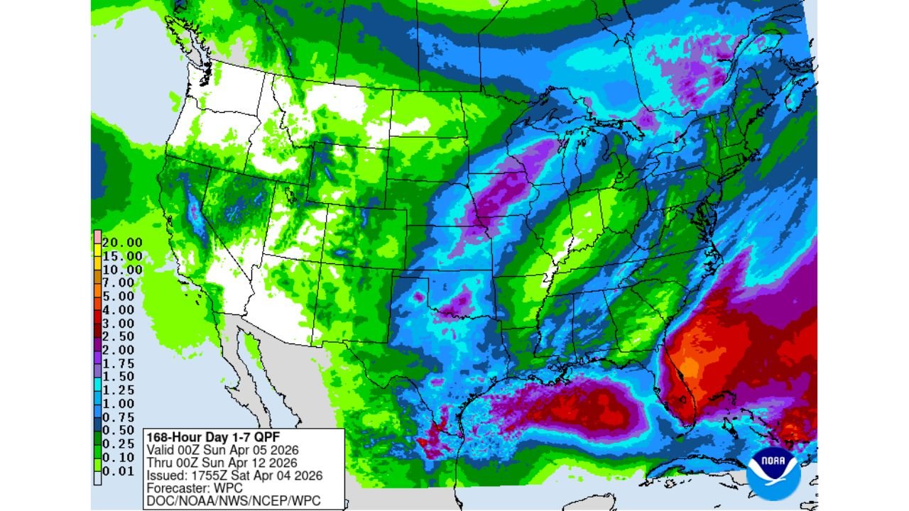
FLORIDA — A notable shift toward a wetter pattern is now expected across the Florida Peninsula, with forecast data showing widespread rainfall totals between 2 to 4 inches and locally higher amounts possible through the upcoming week.
This developing setup is being driven by an old cold front that is expected to stall over Florida, allowing moisture to linger and rainfall to build over several days.
Widespread Rainfall Expected Across the Peninsula
Forecast guidance highlights:
- 2 to 4 inches of rain likely across most of Florida
- Higher localized totals possible, especially along the east coast and central regions
- Rainfall spread across multiple days rather than a single event
Cities expected to see meaningful rainfall include:
- Miami
- West Palm Beach
- Orlando
- Tampa
- Jacksonville
This is shaping up to be one of the more widespread rainfall events Florida has seen in recent weeks.
Stalled Front Creating a Prolonged Rain Setup
The key driver behind this event is a frontal boundary slowing down and stalling over the state.
This type of pattern leads to:
- Repeated rounds of showers and thunderstorms
- Bands of rain moving over the same areas
- Increased potential for locally heavier accumulations
Instead of quickly clearing out, the system will linger long enough to maximize rainfall totals.
Drought Relief Possible But Not Complete
This rainfall event could bring some relief to ongoing dry conditions, especially across:
- Central Florida
- Parts of South Florida
However:
- The rainfall will not completely eliminate drought conditions
- Some areas may still miss the heaviest rain bands
- Long-term recovery will require multiple events over time
Where the Heaviest Rain Could Fall
Data suggests the highest rainfall potential may focus on:
- East Coast metro areas from West Palm Beach to Miami
- Interior sections of Central Florida near Orlando
- Portions of Southwest Florida, depending on storm track shifts
These regions could see locally higher totals exceeding 4 inches if rain bands persist.
What Residents Should Expect This Week
Florida residents should prepare for:
- Multiple days of unsettled weather
- Periods of steady rain and scattered thunderstorms
- Potential for ponding on roads and localized flooding in poor drainage areas
- Breaks between rain, but overall wet conditions dominating the week
Final Outlook
Florida is entering a much-needed wet stretch, with a stalled front expected to bring 2 to 4 inches of rain across Miami, Orlando, Tampa, Jacksonville, and surrounding areas.
While not a complete solution to drought conditions, this event marks a significant step toward improving moisture levels across the state.
Stay with WaldronNews.com for the latest updates as this prolonged rain event develops across Florida.