
Florida Sees Spotty 1–2 Inch Rainfall Across Central Counties While Much of South Florida Stays Under a Quarter Inch — 10-Day Forecast Turns Dry
UNITED STATES — Florida picked up scattered rainfall over the past 24 hours, with some central counties receiving more than an inch — and a few isolated areas topping 2 inches — but much of the peninsula saw lighter totals that will only make a small dent in ongoing drought conditions.
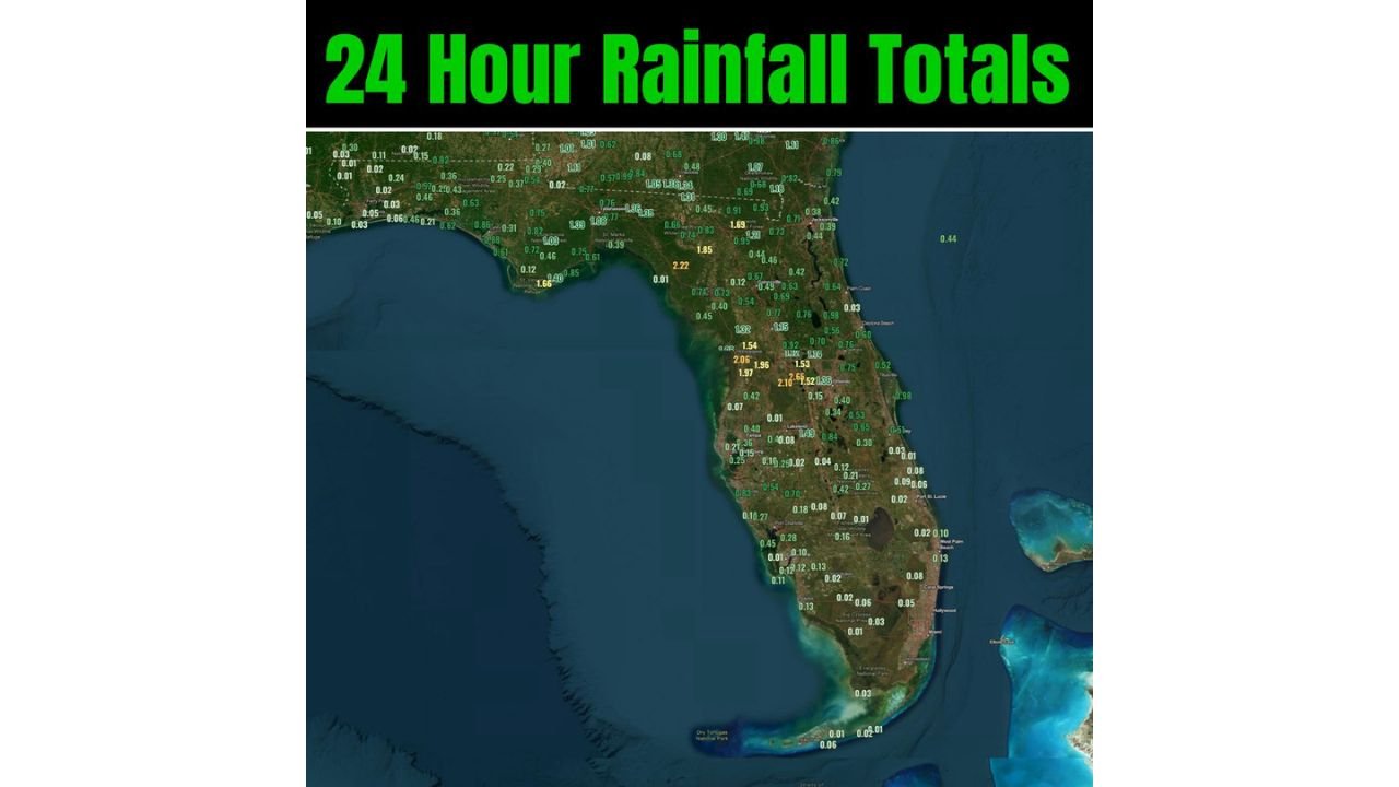
The latest 24-hour rainfall map shows a mixed pattern across the state, with heavier totals clustered in parts of the Florida Panhandle and central interior counties.
Central Florida Records the Heaviest Totals
The most notable rainfall amounts were observed across portions of:
- Central Florida near Orlando
- Interior counties stretching south toward the Lake Okeechobee region
- Parts of the eastern Florida Panhandle
Several reporting stations showed:
- 1.5 to 2.6 inches in localized pockets
- Widespread 0.5 to 1.0 inch totals across central sections
One highlighted area in the central peninsula registered just over 2.6 inches, marking the highest concentration on the map.
Panhandle and North Florida See Moderate Rain
Across the Florida Panhandle — including areas west of Tallahassee — rainfall totals generally ranged from:
- 0.5 to 1.8 inches
- Isolated spots exceeding 2 inches
However, amounts tapered quickly outside the heavier bands, with some communities reporting less than half an inch.
South Florida Remains Largely Dry
Farther south, rainfall was far less impressive.
From Fort Myers to Miami and the Florida Keys, most totals were:
- Under 0.25 inches
- Many locations reporting just 0.01 to 0.10 inches
The Florida Keys saw minimal rainfall overall, with only trace amounts reported in several areas.
Helpful, But Not a Drought Breaker
While the rainfall was welcome — especially in central Florida — it is unlikely to significantly alter long-term drought conditions.
The general breakdown across the state:
- Many locations: around half an inch
- Some pockets: over 1 inch
- Few isolated areas: 2+ inches
- South Florida: minimal accumulation
The distribution was uneven, meaning some communities benefited more than others.
Dry Pattern Ahead
Forecast guidance suggests that the next 10 days look largely dry across much of Florida.
Without additional storm systems in the near term, soil moisture improvements from this event could fade quickly, especially in southern sections where totals were limited.
Residents across Florida should monitor updated drought reports and extended forecast outlooks as the state heads deeper into the late winter dry season.
WaldronNews.com will continue tracking rainfall trends and upcoming weather patterns across the Southeast.