
Florida Set for 75–90° Late-February Surge as Miami, Fort Myers and Orlando Climb 10–15° Above Normal
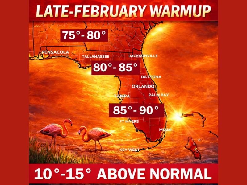
FLORIDA — A dramatic late-February warmup is set to send temperatures soaring across the Sunshine State, with many inland communities expected to reach the mid-80s to near 90 degrees, running 10 to 15 degrees above seasonal averages.
The pattern shift suggests winter may be tapping out early across much of the peninsula, especially following the Daytona 500 weekend, as a strong warm ridge builds over the region.
South Florida Heating Up Fast
The warmest readings are forecast across South Florida, including:
- Miami
- Fort Myers
- Naples
- Key West
High temperatures in these areas are expected to range between 85° and 90°, particularly inland locations away from immediate coastal influence.
This level of heat in late February is well above average and could feel more like late April or early May.
Central Florida Turning Hot
Across Central Florida, including:
- Orlando
- Tampa
- Palm Bay
- Daytona Beach
Afternoon highs are projected in the 80° to 85° range, with some inland neighborhoods pushing even higher.
Air conditioning may be needed in interior sections as the warmth builds under strong sun and minimal cloud cover.
North Florida Also Warming
Even the Panhandle and northern counties are expected to trend warmer, including:
- Jacksonville
- Tallahassee
- Pensacola
Temperatures there should reach 75° to 80°, which is still well above normal for this time of year.
Beaches Stay Cooler — But Fog Possible
While inland communities heat up, coastal areas may remain slightly cooler due to:
- The chilly Atlantic Ocean
- The cooler Gulf of Mexico waters
Beachside highs may stay in the upper 70s, particularly along:
- The Atlantic Coast
- The immediate Gulf shoreline
Forecasters also note the potential for sea fog, especially where warm air moves over cooler ocean waters.
10–15 Degrees Above Normal
This warmup is expected to run 10° to 15° above average statewide. That places much of Florida firmly in springlike territory despite it still being February.
The shift comes as a persistent ridge pattern dominates the Southeast, limiting cold air intrusions and allowing strong solar heating during the day.
What This Means
Residents should prepare for:
- Hot afternoons inland
- Strong sunshine
- Increased UV exposure
- Potential sea fog near coastal communities
With the warmth arriving early, sunscreen season may be getting an early start this year. Stay with WaldronNews.com for continued updates on Florida’s late-winter warm surge and other major weather pattern shifts across the United States.