
Florida, Texas, Georgia, and Alabama to See Warmer-Than-Normal Christmas Day as Mild Pattern Spreads Across Much of the U.S.
ORLANDO, FLORIDA — Christmas Day 2025 is shaping up to feel noticeably warmer than normal across much of the southern and central United States, with forecast models showing above-average daytime temperatures from Texas through the Southeast and possible 80-degree highs in parts of Florida, according to the latest blended temperature guidance.
While the pattern has sparked widespread discussion online, meteorologists note that conditions will still feel seasonable in the mornings, and the warmth is not expected to resemble a classic winter heat wave.
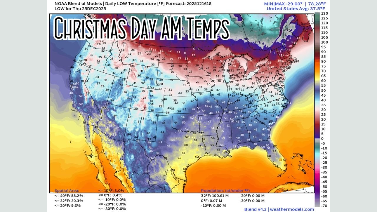
Christmas Morning Will Still Feel Chilly for Many
Despite warmer daytime readings, maps showing Christmas Day morning low temperatures indicate that much of the country will wake up to cool or cold conditions, especially across the Midwest, Ohio Valley, and Northeast.
Early-day lows are expected to fall into:
- The 20s and 30s across northern states
- The 40s and 50s across much of the South
- The 50s to near 60 in parts of the Gulf Coast and Florida
This means Christmas will still start with a winter feel, even in areas that warm quickly later in the day.
“It may not feel like winter by the afternoon, but most places will still start Christmas morning on the chilly side.”
Daytime Highs Trending Well Above Normal
Forecast anomaly maps show widespread positive temperature departures, especially across the Southern Plains, Lower Mississippi Valley, and Southeast.
Many areas are projected to run 10 to 25 degrees above average for late December, with the strongest warmth centered over:
- Texas
- Louisiana
- Mississippi
- Alabama
- Georgia
- Florida
In central and southern Florida, daytime highs could reach the upper 70s to near 80 degrees, while much of the Southeast sees lower to mid-70s.
Why This Pattern Feels So Mild
Meteorologists say the warmth is tied to a broad ridge of high pressure dominating the central and southern U.S., allowing milder air to spread northward while colder air remains bottled up farther north.
The middle of the country appears especially warm compared to past Christmases, though experts emphasize this is not a record-shattering setup nationwide.
“It’s warm relative to normal, but it’s not a true ‘torch’ pattern for most locations.”
Northern States Stay Cooler but Less Extreme
While the South warms up, the Upper Midwest, Great Lakes, and Northeast remain closer to seasonal norms, with some areas still experiencing below-average temperatures, particularly during the morning hours.
This keeps snow cover intact in northern regions and prevents a full-scale winter retreat across the entire country.
Bottom Line for Christmas Day
- Warm afternoons across the South and central U.S.
- Chilly mornings remain common nationwide
- Florida could see near-summer warmth, especially inland
- No widespread extreme heat, just a milder-than-normal holiday
Residents traveling for the holiday should prepare for large temperature swings between morning and afternoon, especially across the Southeast.
WaldronNews.com will continue monitoring updated forecasts as Christmas Day approaches and provide additional outlooks if trends shift.