
Florida’s I-4 Corridor on Alert as Tropical-Level Moisture Surges In, Raising Thunderstorm and Lightning Concerns Friday Night
UNITED STATES — A surge of deep Gulf and Atlantic moisture is setting the stage for a growing thunderstorm threat across central Florida and the I-4 corridor Friday evening into the overnight hours, with forecasters highlighting unusually high atmospheric moisture and increasing lightning potential.
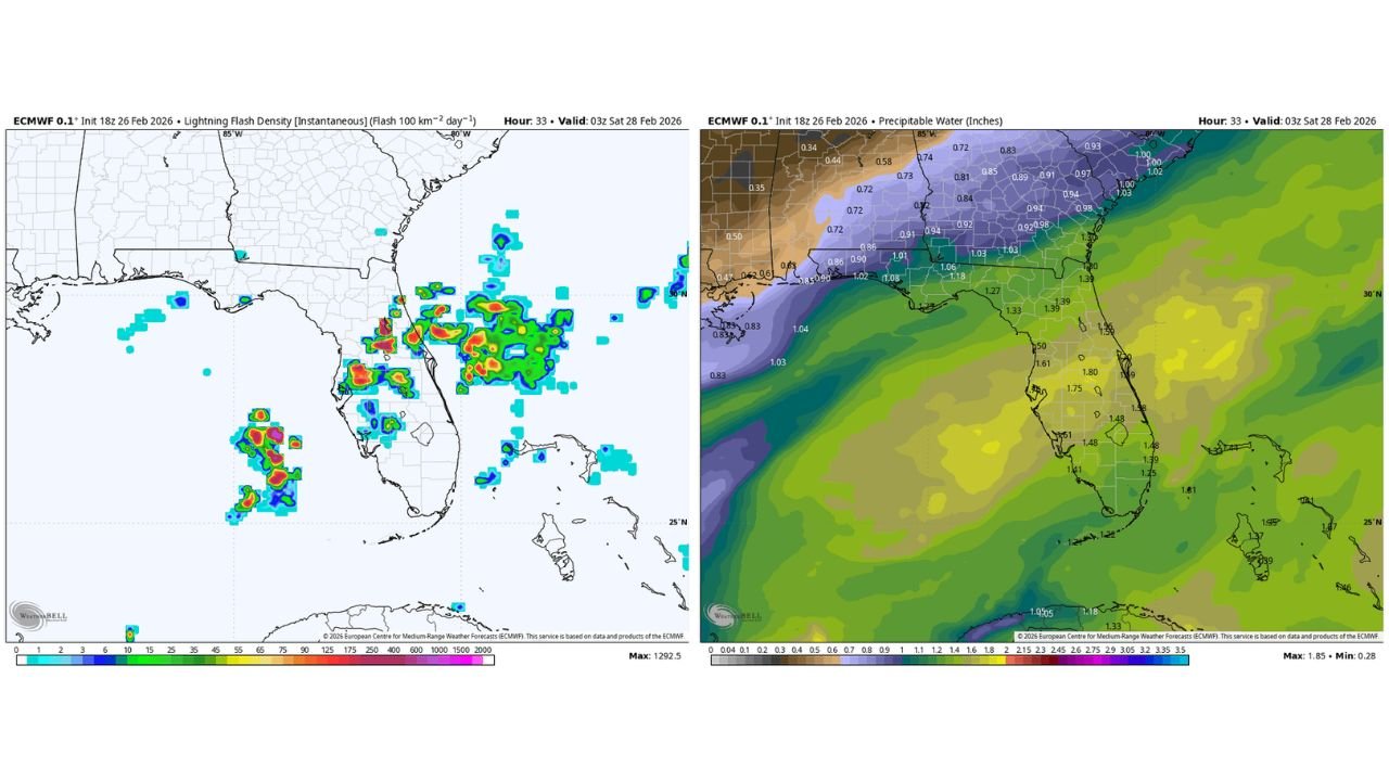
New ECMWF guidance valid late Friday night shows precipitable water (PWAT) values climbing to 1.75 to 1.85 inches across central and southern Florida — some of the highest readings observed in recent weeks.
That level of moisture is more typical of late spring or early summer than late February.
Moisture Surge Fueling Storm Development
The precipitable water map indicates:
- 1.70″+ values spreading north into the I-4 corridor
- Deep tropical moisture pooling across central and south Florida
- Sharply lower moisture across the Southeast outside of Florida
This moisture axis provides ample fuel for downpours and lightning-producing storms.
When PWAT values approach or exceed 1.75 inches, storms are capable of:
- Heavy rainfall in short bursts
- Frequent lightning
- Localized ponding on roads
Lightning Signal Increasing
The lightning flash density forecast highlights scattered to numerous thunderstorm clusters developing across central Florida, particularly near and south of the I-4 corridor.
The model shows:
- Higher lightning density signatures near the west-central and central peninsula
- Offshore storm clusters in the eastern Gulf
- Activity expanding eastward overnight
While not necessarily signaling widespread severe weather, the pattern supports electrically active storms.
Mid-Level Winds Add Organization
Forecasters also note that decent mid-level winds are present, which can help storms organize more efficiently compared to typical sea-breeze-driven convection.
This means:
- Storms could persist longer
- Downpours may be more concentrated
- Lightning activity may be more robust
Wildfire Areas Could Face Additional Risk
An important secondary concern involves lightning near existing wildfire-prone zones.
Dry surface fuels combined with lightning strikes — even with scattered rainfall — can create new fire starts or complicate ongoing fire control efforts.
Timing: Friday Evening Into Overnight
The primary window for stronger storm development appears to be:
- Late Friday afternoon
- Friday evening
- Continuing into early Saturday morning
Storms may gradually shift offshore or weaken toward daybreak Saturday.
The Bottom Line
Central Florida and the I-4 corridor are facing a growing thunderstorm risk Friday evening as tropical-level moisture surges northward, with PWAT values exceeding 1.75 inches and lightning density forecasts increasing across the peninsula.
While not a classic severe outbreak setup, the combination of deep moisture and supportive winds could bring heavy downpours, frequent lightning, and localized impacts — particularly after sunset.
WaldronNews.com will continue monitoring evolving thunderstorm trends across the Southeast and tracking how moisture surges like this influence broader weather patterns moving eastward.