
Florida’s West Coast Could See Rare ‘Gulf-Effect’ Snow Flurries Late Saturday as Arctic Air Interacts With Warm Gulf Waters
FLORIDA — A highly unusual winter setup could briefly unfold along Florida’s west coast late Saturday night, where forecasters are monitoring the potential for non-accumulating snow flurries driven by a process similar to lake-effect snow in the Great Lakes region.
Meteorologists stress that this is a low-probability, high-interest scenario, but recent data suggests the atmospheric ingredients may briefly align to support what is being referred to as “Gulf-effect snow.”
Why Snow Is Rare in Florida — And What’s Different This Time
Under normal winter cold snaps in Florida, temperatures may dip low enough to support snow in theory, but the atmosphere is usually too dry to produce precipitation.
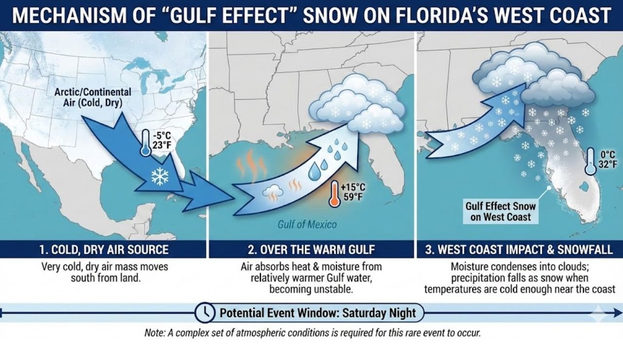
This weekend’s setup is different because of three interacting factors shown in the data:
- Very cold, dry Arctic air pushing south into the Southeast
- Relatively warm Gulf of Mexico waters, providing heat and moisture
- Onshore flow toward Florida’s west coast, allowing moisture to be lifted into the cold air mass
As the cold air moves over the warmer Gulf waters, it can absorb just enough moisture and instability to generate clouds and light precipitation, similar to how cold air crossing Lake Erie fuels snow in Buffalo.
How “Gulf-Effect” Snow Would Form
The mechanism breaks down into a three-step process:
- Cold continental air surges southward from land into the Gulf region
- Warm Gulf waters add moisture and heat to the lower atmosphere
- As air moves inland, moisture condenses into clouds, and if surface temperatures are cold enough, snowflakes can briefly form
Forecast graphics indicate surface temperatures hovering near 32°F (0°C) along parts of the west coast, just barely cold enough to support snow if precipitation develops at all.
What to Expect — And What Not to Expect
Forecasters emphasize several important limitations:
- No accumulation is expected
- Any snow would be brief, spotty flurries
- Coverage would be isolated, not widespread
- The window is short, mainly late Saturday night
Most locations would see nothing at all, but a few coastal or near-coastal areas could experience fleeting snowflakes mixed with cloud cover, especially if moisture transport is slightly stronger than forecast.
Why Forecasters Are Watching Closely
Even though impacts would be minimal, this setup is meteorologically significant because Florida almost never has the moisture and cold overlap needed for snow. Small changes in wind direction, temperature, or moisture depth could be the difference between nothing happening and a brief, historic flurry report.
That’s why meteorologists are calling this a “fun forecast challenge” — not a storm threat, but a rare atmospheric puzzle.
Bottom Line
A rare Gulf-effect snow setup may briefly develop along Florida’s west coast late Saturday night, but odds remain low and impacts would be negligible. If snow does occur, it would be short-lived, non-accumulating, and highly localized — more of a weather curiosity than a winter event.
Have you ever seen snowflakes in Florida? Share your experience and stay with WaldronNews for continued updates on this rare winter setup.