
Forecast Flags Expanding Severe Storm Risk from Northern Texas Through Eastern Kansas and Into Missouri for Friday
UNITED STATES — A machine learning-based forecast from the Global Ensemble Forecast System is highlighting a broad corridor of increased severe weather potential stretching from northern Texas through eastern Kansas and into northwestern Missouri for Friday, signaling an environment that could support strong to severe thunderstorms across the Central Plains.
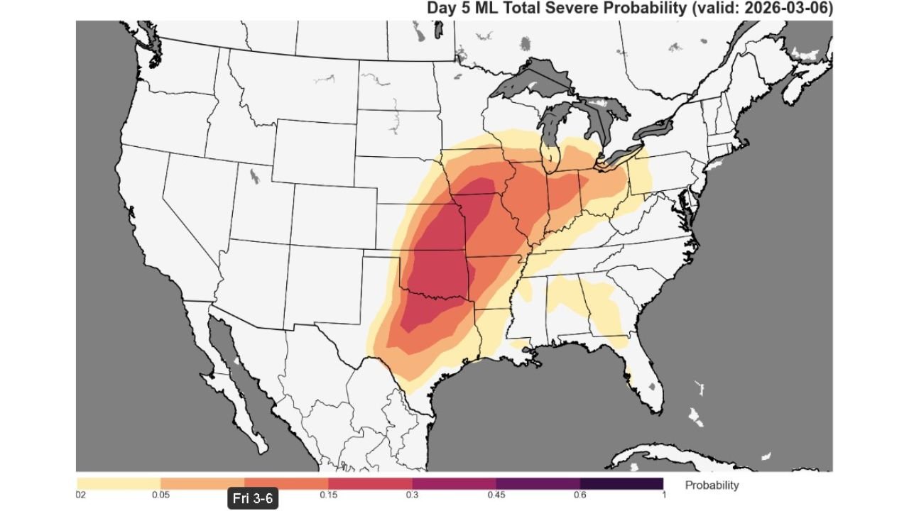
The Day 5 total severe probability map valid Friday, March 6, shows a pronounced swath of elevated risk centered across:
- Northern Texas
- Central and Eastern Oklahoma
- Eastern Kansas
- Northwestern Missouri
- Portions of western Illinois and Iowa
The highest probability zone appears concentrated over central and eastern Oklahoma into eastern Kansas, where the model paints the deepest shading.
Broad Risk Area Emerging
Unlike narrow, localized signals, this model output displays a wide area of concern. The probability gradient expands north-south from Texas into the Mid-Mississippi Valley, suggesting the setup is not confined to a single metro region.
Key highlights from the projection:
- Core severe signal centered over Oklahoma and Kansas
- Secondary extension northeast into Missouri
- Southern flank reaching into north Texas
- Lighter probabilities extending east toward the Ohio Valley
This kind of expansive footprint often indicates strong synoptic-scale support rather than isolated pop-up storms.
Environment Appears Capable
While exact storm placement remains uncertain at this range, the model indicates atmospheric ingredients aligning for organized convection.
Typically, patterns that produce this type of probability signal involve:
- Increasing low-level moisture transport
- Strengthening mid-level wind fields
- Height falls ahead of an approaching trough
- A well-defined warm sector
The combination supports the potential for storms capable of damaging winds, large hail, and possibly tornadoes — though specific hazards will depend on mesoscale evolution.
Not Yet Locked In
Despite the strong signal, forecasters caution that Day 5 projections remain subject to change. Ensemble spread still exists, and small shifts in trough timing or moisture return could alter the highest-risk corridor.
Possible scenarios include:
- A more focused corridor shifting east or west
- A faster-moving system limiting instability
- A slower trough increasing severe coverage
Confidence in a severe-capable environment is growing, but details will sharpen midweek.
What It Means for Arkansas
While Arkansas sits just east of the current highest-probability zone, western portions of the state could see impacts depending on how the system evolves.
Residents across western Arkansas should monitor:
- Wind forecast trends
- Moisture return into the state
- Any eastward expansion of severe probabilities
At this stage, Arkansas is near the eastern edge of the primary signal, but adjustments are possible.
Bottom Line
An AI-driven ensemble forecast is flagging a broad and potentially significant severe weather setup for Friday across the Central Plains — particularly from northern Texas into eastern Kansas and Missouri.
Though not finalized, the pattern supports close monitoring through the week.
Stay with WaldronNews.com for continued updates as forecast confidence increases and we assess potential impacts for Arkansas and surrounding states.