
Forecast Models Signal Potential Cold Storm Series Beginning Presidents’ Day Weekend With Low Snow Levels and Significant Snow Possible
UNITED STATES — Forecast models continue to highlight the growing potential for a cold, multi-storm pattern developing over Presidents’ Day weekend and extending through the middle of next week, according to the latest ensemble and deterministic model guidance.
While it remains too early to pinpoint exact impacts or totals, confidence is increasing that the overall pattern could support multiple rounds of snowfall, with low snow levels suggesting impacts beyond just higher elevations if the colder solutions verify.
Model Agreement Increasing on Cold Pattern
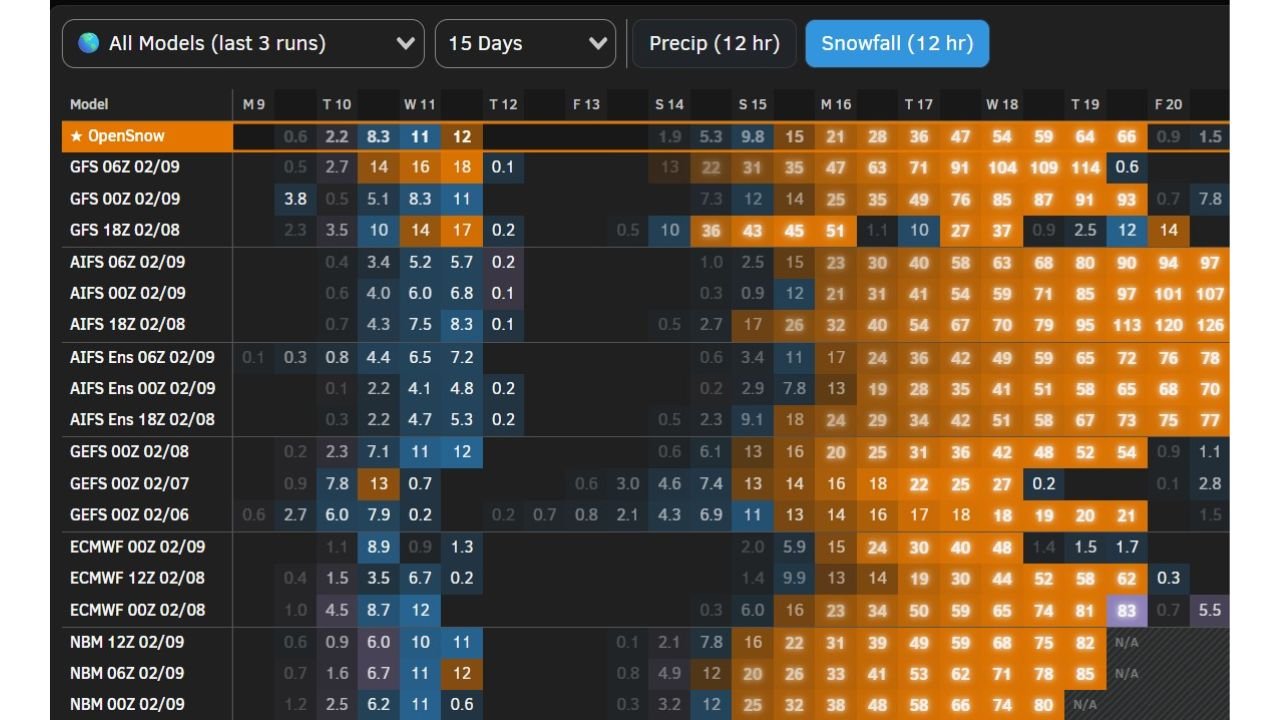
Recent model runs, including GFS, ECMWF, GEFS, AIFS, NBM, and OpenSnow guidance, show a consistent signal for repeated snowfall opportunities beginning late in the holiday weekend and continuing into the following week.
Snowfall accumulation output increases steadily across multiple forecast cycles, with several model solutions showing successive snow events rather than a single system, a key indicator of a prolonged cold pattern rather than a brief storm.
Low Snow Levels Remain a Key Signal
One of the more notable aspects of the current guidance is the continued indication of low snow levels, suggesting colder air will be firmly in place during at least part of the storm sequence.
This raises the possibility that snow impacts could extend into areas that typically rely on marginal temperatures, depending on how each storm evolves and how quickly cold air is reinforced between systems.
Timing Still Uncertain, But Window Is Clear
- Pattern onset: Around Presidents’ Day weekend
- Duration: Potentially lasting into the middle of next week
- Storm type: Multiple cold systems rather than a single event
Forecasters emphasize that specific snowfall amounts, locations, and exact storm timing remain uncertain at this range. However, the persistence of the signal across consecutive model runs suggests the setup is worth close monitoring.
What Happens Next
As the pattern comes into clearer focus, confidence will increase regarding snowfall totals, snow levels, and which areas are most likely to be impacted. Small shifts in storm track or temperature profiles could significantly influence outcomes, particularly where rain-snow lines are involved.
For now, the takeaway is that a colder-than-normal stretch with meaningful snowfall potential is increasingly supported by the data, even if details remain unresolved.
WaldronNews.com will continue tracking this developing cold pattern and provide updates as higher-resolution forecasts become available.