
Friday–Saturday Snow Targets Connecticut, Rhode Island and Massachusetts, With a Small Zone That Could Surprise at 6–10 Inches
UNITED STATES — A two-part snow setup is unfolding across southern New England: some coastal snow showers today (Friday), then a more organized round of snow Saturday, with the majority of accumulation expected between 8 a.m. and 4 p.m. The forecast map highlights widespread light-to-moderate totals, but it also flags a familiar winter wildcard—a narrow band where “surprise” higher totals could pop if conditions line up.
Saturday is the main event window: 8 a.m. to 4 p.m.
Friday’s activity is expected to be more hit-or-miss near the coast, but the guidance emphasizes that Saturday is when the bulk of the snow falls, especially during the daytime.
That timing matters because it can create:
- Snow-covered roads during peak daytime travel
- Slower plowing response in heavier bursts
- Rapid changes in visibility if a heavier band develops for even a few hours
Expected snow totals by region
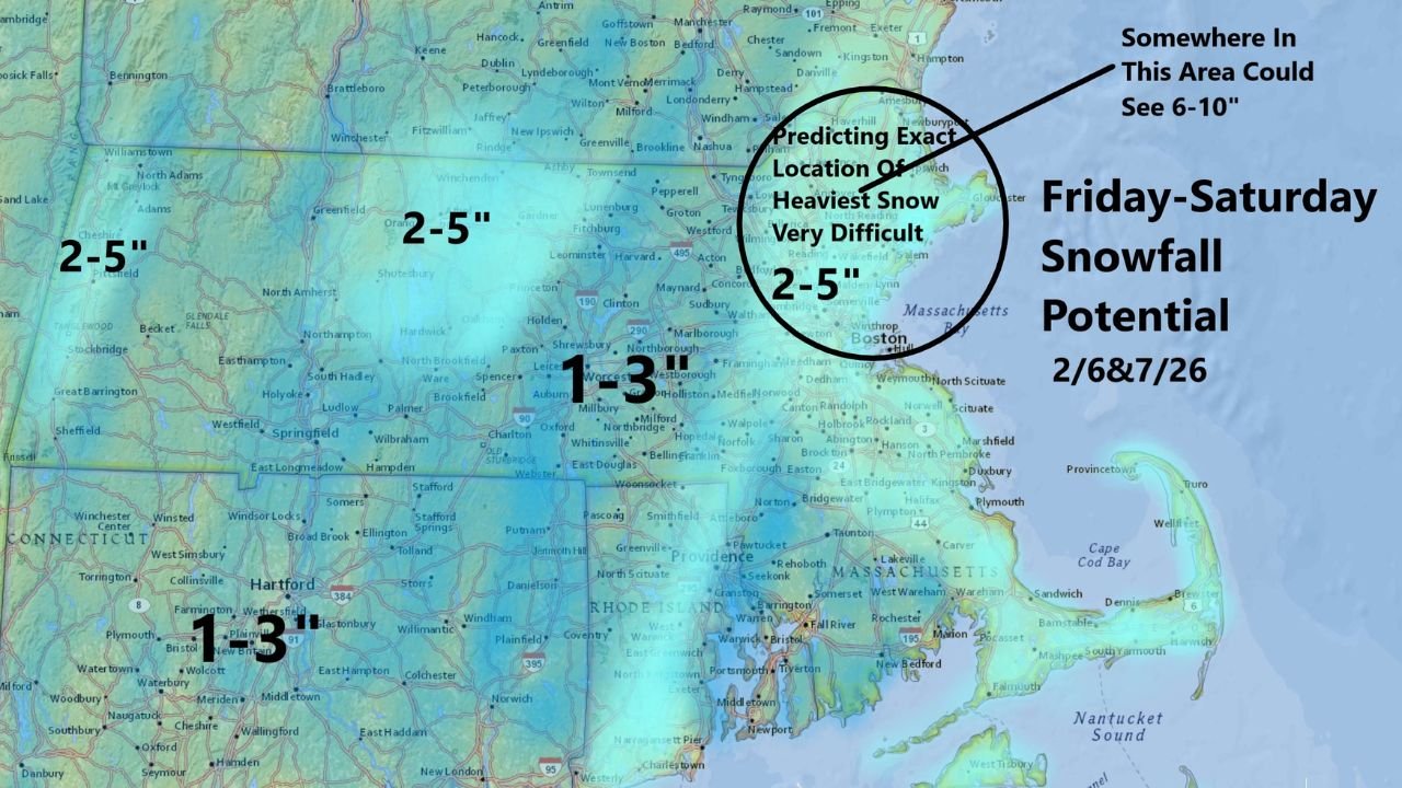
The map breaks the forecast into a few clear zones across Connecticut, Rhode Island, and Massachusetts:
Connecticut (CT)
- Most areas: 1–3 inches
- The emphasis is on a manageable snowfall, but enough to create slick roads—especially if temperatures stay cold.
Rhode Island (RI)
- Generally: 1–3 inches
- Coastal locations may deal with periodic snow showers Friday, then steadier snow Saturday.
Massachusetts (MA)
- Many areas: 2–5 inches, including parts of central and northern Massachusetts
- Some areas closer to southern/central Massachusetts: 1–3 inches
- Coastal northeast Massachusetts area: 2–5 inches, with uncertainty on where the heaviest band sets up
The overall theme: most communities land in a light-to-moderate range, but totals can jump quickly if a band forms and lingers.
The “surprise” zone: where 6–10 inches could show up
The forecast graphic includes a circled area over northeastern Massachusetts and nearby coastal zones, noting:
- “Predicting exact location of heaviest snow very difficult”
- “Somewhere in this area could see 6–10”
This is not a guarantee. It’s a heads-up that if a narrow band sets up in the right place, one or two towns could end up with totals that look dramatically higher than surrounding communities.
When forecasters flag a 6–10″ “somewhere” zone, it usually means:
- The storm’s snow band placement is still uncertain
- The difference between 3 inches and 8 inches may be a 20–30 mile shift
- The outcome could be decided by how quickly the snow intensifies Saturday morning and whether the band stalls
Why the heaviest snow location is so hard to pin down
This kind of setup often involves a trough/banding feature that can pivot or wobble. Even if the overall storm is modest, a narrow zone can briefly produce:
- Higher snowfall rates
- Faster accumulation
- Local totals that beat the general forecast by several inches
That’s why the map keeps most places in the 1–3″ and 2–5″ buckets, while carving out the “if it works out” zone for the biggest numbers.
Travel impact: messy at times, especially Saturday
Even a 1–3″ snowfall can cause issues if it falls steadily during the day. If you’re traveling Saturday, plan for:
- Slower highway speeds
- Slick ramps and bridges
- Visibility drops during any heavier bursts
If you’re inside the “possible 6–10” area, conditions could deteriorate quickly if banding develops—meaning plows may struggle to keep up for a few hours.
What to watch early Saturday morning
If you want the best clue on whether your town is heading toward a higher total, watch for:
- Snow becoming steadier and thicker shortly after daybreak
- Visibility dropping quickly even without wind
- Nearby towns reporting totals climbing faster than expected by late morning
That’s usually when the “surprise zone” declares itself.
Woke up to snow where you are in Connecticut, Rhode Island, or Massachusetts? Tell us what you’re seeing—light showers or steadier accumulation—and keep following updates on WaldronNews.com.