
Georgia, Alabama, Tennessee and the Carolinas Face Another Dry Week With Rain Chances Staying Very Low Through Saturday as Southeast Waits for Possible Storm System Sunday to Monday
ATLANTA, GEORGIA — Residents across Georgia, Alabama, Tennessee, North Carolina and South Carolina who have been desperately waiting for rain are facing more disappointing news — meaningful rainfall is not expected across much of the Southeast through Saturday morning, and even the isolated chances that do exist between now and Friday will amount to very little for most communities. Many areas across the Southeast have not seen rain in at least two weeks — dating back to a severe weather event that ultimately did not deliver the rainfall that was expected. The next real opportunity for broader rain coverage may not arrive until the Sunday to Monday timeframe, and even that is far from guaranteed.
Who Is Getting Rain and Who Is Not
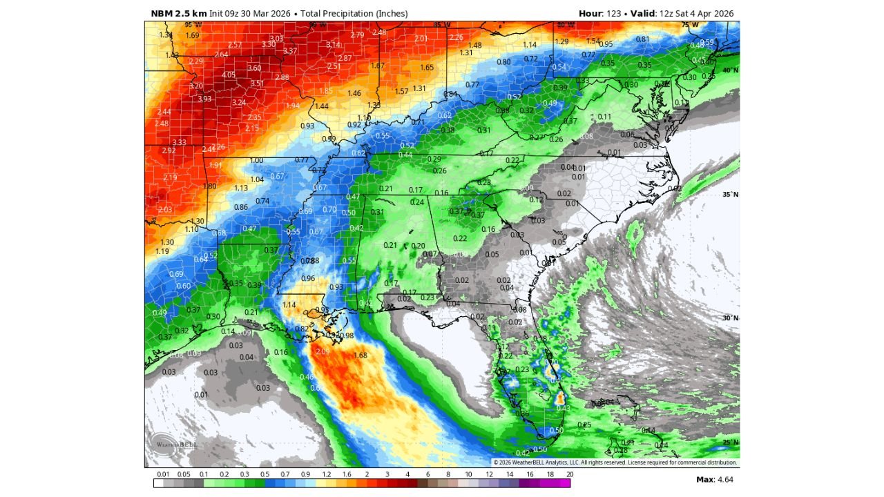
The NBM 2.5 km precipitation model, initialized March 30, 2026 and valid through Saturday April 4, tells a very clear story about where the rain is going — and it is largely bypassing the Southeast:
Getting significant rain — but NOT the Southeast:
- Missouri, Illinois, Indiana and Iowa — 2 to 4 inches or more of rainfall through April 4
- Kansas and Nebraska — heavy rainfall totals of 2 to 4+ inches across the Plains
- Ohio and Michigan — 1 to 2 inches of rainfall associated with the active Midwest storm pattern
- Texas Gulf Coast and Louisiana — some meaningful rainfall totals of 1 to 2 inches along the coast
Very little to no rain — the dry Southeast:
- Georgia — most of the state seeing 0.01 to 0.20 inches at best through Saturday
- Alabama — similarly parched, with only isolated light totals possible
- Tennessee — most areas under 0.20 to 0.50 inches at best, with many locations seeing far less
- North Carolina and South Carolina — largely dry through Saturday with only isolated traces possible
- Mississippi — minimal rainfall expected through the weekend
- Virginia — very light totals, well under half an inch for most
Why the Southeast Keeps Missing the Rain
The frustrating reality for Georgia, Alabama, Tennessee and the Carolinas right now is that most of the weather energy is pivoting around the Southeast rather than moving through it. The active storm systems that are delivering heavy rainfall to the Midwest and Plains are tracking on a path that keeps the bulk of the moisture and lift to the north and west of the Southeast states. The result is a pattern where storms fire all around the region but leave Georgia, Alabama and the Carolinas in a dry pocket.
This is not unusual for certain spring atmospheric patterns — but it is deeply frustrating for a region that is already running two or more weeks behind on rainfall. The isolated rain chances between now and Friday are real but extremely low confidence — meaning even the small amounts shown on the forecast model are far from certain to materialize for any specific community across the Southeast.
The Sunday to Monday Window — The Best Hope
The most credible opportunity for broader and more meaningful rainfall across the Southeast comes during the Sunday to Monday timeframe. A larger storm system may be able to move into the region during that window — one that could finally break through the dry pattern and deliver rain to communities across Georgia, Alabama, Tennessee and the Carolinas that have been waiting for weeks.
However, forecasters are being honest that confidence is not high in this scenario right now. The track, timing and intensity of the potential Sunday to Monday system still carry significant uncertainty. If the storm system tracks further north than currently expected, the Southeast could once again find itself on the dry side of the precipitation shield. If it tracks favorably, communities across Atlanta, Birmingham, Nashville, Charlotte and Raleigh could finally see meaningful rainfall totals.
The bottom line — do not cancel your weekend outdoor plans based on rain expectations through Saturday, but keep a close eye on forecasts heading into next weekend as the Sunday to Monday system becomes clearer.
What This Means for Drought Conditions
Two-plus weeks without meaningful rain across the Southeast is not just an inconvenience — it is building drought stress that will be felt in lawns, gardens, agriculture and water supplies across Georgia, Alabama, Tennessee, North Carolina and South Carolina. The longer this dry pattern persists, the deeper the moisture deficit grows and the more rain will eventually be needed to restore normal conditions.
For context — even the isolated low-end rain chances between now and Friday will not make a meaningful dent in the deficit that has accumulated across the Southeast over the past two weeks. The region needs a genuine, broad soaking event — and the earliest that could realistically arrive is the Sunday to Monday window.
What to Watch Next
- Sunday to Monday storm system — whether it tracks favorably to bring rain to Georgia, Alabama, Tennessee and the Carolinas or pivots around the Southeast again
- Model agreement on the Sunday system track — the next 48 to 72 hours of model runs will sharpen this picture considerably
- Any isolated showers Friday across Tennessee and northern Georgia — the most likely spot for any pre-weekend rain activity
- Drought monitor updates — whether Georgia, Alabama and the Carolinas see drought conditions officially worsen on the next US Drought Monitor release
- Rain totals if Sunday system delivers — whether any event produces enough to make a real dent in the two-week deficit across the Southeast
Residents across Atlanta, Georgia, Birmingham, Alabama, Nashville, Tennessee, Charlotte and Raleigh, North Carolina should manage expectations through Saturday and focus attention on the Sunday to Monday window as the next real opportunity for meaningful rainfall.
WaldronNews.com will continue tracking rainfall chances across the Southeast and provide updates as the Sunday to Monday storm system potential comes into clearer focus over the next several days.