
Georgia, Florida, Alabama and Carolinas Told to Watch Worsening Drought Pattern as New Forecast Shows Rain Staying Away
UNITED STATES — A concerning weather pattern is unfolding across the Southeast United States, where new forecast data is signaling that rainfall will remain limited while drought conditions continue to expand and intensify.
Despite ongoing storm activity across the Plains and other parts of the country, the Southeast is expected to remain largely cut off from meaningful rainfall, raising concerns for a prolonged dry and potentially damaging stretch.
Widespread Drought Already Covering the Southeast
Latest data shows that a large portion of the Southeast is already in drought, with conditions ranging from:
- Abnormally dry across the Carolinas and Virginia
- Moderate to severe drought across Georgia and Alabama
- Extreme drought conditions developing across Florida and southern Alabama
This widespread coverage means the region is already under significant moisture stress, even before the next dry period begins.
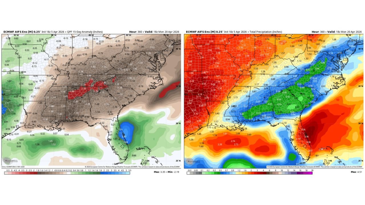
Rainfall Deficit Expected to Expand Over the Next Two Weeks
Forecast models are now projecting a continued lack of rainfall across the Southeast, especially through the next 10 to 15 days.
Key signals include:
- Large areas of negative precipitation anomalies, indicating below-normal rainfall
- A clear pattern where storm systems track west and north of the region
- Limited moisture return from the Gulf of Mexico into inland areas
Some of the driest zones are expected across:
- Central and northern Georgia
- Alabama
- South Carolina
- Parts of North Carolina
These regions are likely to see minimal rainfall accumulation, further worsening existing drought conditions.
Storm Activity Bypasses the Southeast
While the Central Plains and Midwest are expected to see active storm sequences, the Southeast remains under a suppressed pattern.
This means:
- Storm systems are developing elsewhere and not reaching the region
- The Southeast remains dominated by dry air and stable conditions
- Rainfall opportunities become increasingly rare
This setup is particularly problematic because it creates a persistent dry zone surrounded by active weather elsewhere.
Temperature and Dry Air Combine to Accelerate Drought
In addition to the lack of rainfall, the region is also expected to experience:
- Above-normal temperatures
- Increased sunshine and evaporation
- Continued influence of dry air masses
This combination will accelerate:
- Soil moisture loss
- Vegetation stress
- Expansion of drought severity levels
The longer this pattern continues, the more likely it is that the Southeast will face a deepening drought crisis heading into late spring and summer.
Why This Pattern Is Especially Concerning
This is not just a short-term dry spell — it reflects a larger atmospheric setup that is unfavorable for rainfall in the Southeast.
At the same time, global signals indicate a strengthening El Niño pattern, which typically:
- Reduces tropical system activity in the Atlantic
- Limits summer rainfall contributions from tropical moisture
- Keeps the Southeast in a drier-than-normal regime
This raises the possibility of a long-duration drought extending into summer.
Key States That Should Stay Alert
The most impacted areas include:
- Georgia
- Florida
- Alabama
- South Carolina
- North Carolina
These states are directly within the core drought zone and projected rainfall deficit area.
What This Means for Residents and Agriculture
For communities across the Southeast, this pattern could lead to:
- Increasing water stress and usage concerns
- Agricultural impacts, especially for early-season crops
- Greater risk of wildfire conditions in dry areas
- Continued deterioration of soil moisture levels
Without consistent rainfall, conditions could worsen quickly over the next few weeks.
What to Watch in the Coming Days
Residents should closely monitor:
- Any changes in storm track patterns
- Potential rainfall chances later in April
- Updates to drought expansion and severity levels
Even small shifts in the pattern could bring relief, but right now, the trend clearly points toward continued dryness and worsening drought conditions.
Stay with WaldronNews.com for ongoing updates as this developing drought pattern across Georgia, Florida, Alabama, and the Carolinas continues to evolve.