
Georgia Sees Cold Air Return Wednesday Night With Only Minor Snow Chances in North Georgia Mountains
GEORGIA — After a brief and mild warmup, cold air is set to return across Georgia late Wednesday night into Thursday, bringing a small chance of light snow showers, primarily confined to far north Georgia and the highest elevations of the Blue Ridge Mountains. Forecast data shows moisture will be very limited, keeping impacts minimal for most of the state.
While this will not be a widespread winter weather event, it marks another reminder that mid-January cold is not finished, especially for northern counties.
Where Snow Is Possible — and Where It Is Not
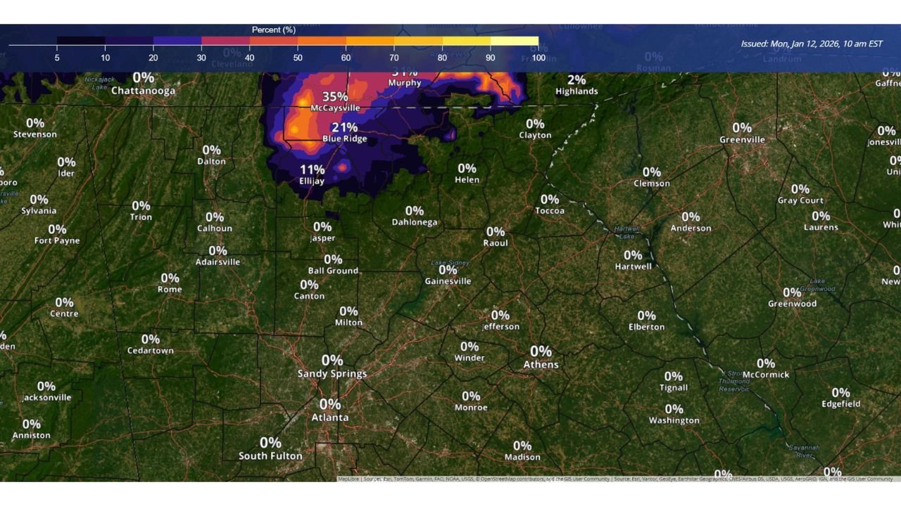
Latest probability maps from the National Weather Service indicate:
- Far North Georgia (mountain counties):
A 20–35% chance of at least 0.5 inches of snow, mainly near areas such as Blue Ridge, McCaysville, and Ellijay. - Highest elevations:
Slightly better odds for minor accumulation, though totals are still expected to remain light. - Metro Atlanta and most of North/Central Georgia:
Near 0% chance of measurable snow, with no impacts expected. - East and South Georgia:
Temperatures stay cold but no snow risk due to lack of moisture.
Expected Snow Amounts
Even in the favored areas, accumulations are expected to be minor, generally:
- Trace to 0.5 inches
- Possibly slightly higher on the highest mountain peaks
Road impacts are unlikely outside of brief slick spots at elevation, especially late Wednesday night or early Thursday morning.
Temperature Shift Will Be More Noticeable Than Snow
While snow chances remain low, the temperature drop will be more widespread.
Forecast highs on Thursday show:
- North Georgia: Upper 30s to low 40s
- Metro Atlanta: Low to mid 40s
- South Georgia: Upper 40s to low 50s
The colder air will feel sharp compared to recent warmth, especially with early-morning chill Thursday.
Timing Overview
- Wednesday evening: Temperatures begin falling after sunset
- Late Wednesday night – early Thursday: Best window for isolated snow showers in far north Georgia
- Thursday daytime: Cold, dry conditions statewide
What This Means for Travel and Daily Plans
- No widespread travel disruptions expected
- Mountain drivers should remain alert for brief slick spots
- Cold air may impact early commutes, outdoor work, and school mornings
Bottom Line
Georgia will see cold air return midweek, but snow chances remain very limited and are confined to far north Georgia’s highest elevations. Any accumulation should stay light and localized, with cold temperatures being the main story statewide.
Stay with Waldron News for updates on North Georgia mountain conditions and any changes to the late-week forecast.