
Georgia, South Carolina, and North Carolina Enter Watch Phase for Potential Jan. 31–Feb. 1 Winter Storm as Cold Air Locks In Across the Southeast
UNITED STATES — Forecasters are now flagging a clear signal to monitor for next weekend, as pattern recognition shows a favorable setup for wintry weather across the Southeast during January 31 through February 1. While exact impacts are still uncertain, the ingredients for a winter event are increasingly lining up — particularly plentiful cold air already in place.
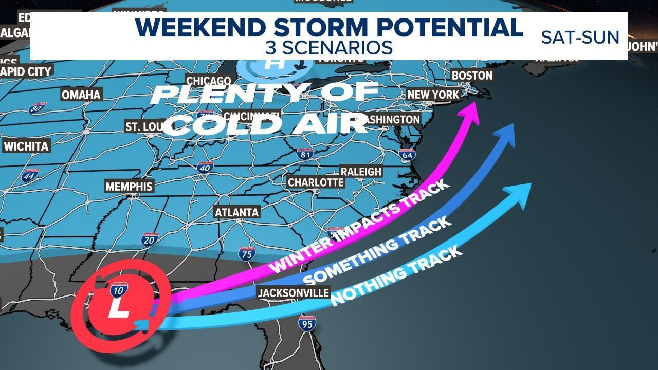
At this stage, meteorologists emphasize that the outcome depends almost entirely on the track of a developing coastal low-pressure system, not the availability of cold air, which is already locked in across much of the region.
Cold Air Is Not the Question
Forecast graphics clearly show deep, widespread cold air entrenched across the eastern United States, extending well into the Southeast. This eliminates one of the biggest limiting factors for winter weather in southern states.
In other words:
The cold is there. What happens next depends on the storm.
Three Possible Scenarios Being Tracked
Forecasters are currently outlining three distinct storm-track scenarios, each with different outcomes:
1) Winter Impacts Track (Higher Impact)
- Coastal low tracks closer to the shoreline
- Greater interaction between moisture and cold air
- Higher chance of meaningful winter weather impacts inland
2) “Something” Track (Lower-End Impacts)
- Storm remains farther offshore
- Cold air remains in place
- Possible brush with light wintry precipitation or mixed weather
3) Nothing Track (Miss Scenario)
- Storm stays well out to sea
- Cold conditions persist
- Little to no winter precipitation occurs
At this range, all three outcomes remain plausible.
Why Forecast Confidence Is Still Limited
Meteorologists stress that this forecast is still in the early “trending” phase, roughly 5–7 days out. That means:
- It is too early for snowfall or ice accumulation maps
- Precipitation type (snow vs. sleet vs. ice) cannot be resolved yet
- Small changes in storm track could significantly change impacts
The graphics reinforce a key rule of winter forecasting:
Details come later — pattern recognition comes first.
Timing Window to Watch
- Primary concern: Saturday, January 31 into Sunday, February 1
- The next 3–5 day window will be critical for narrowing down storm strength and placement
- Confidence is expected to increase as models resolve the coastal low more clearly
Bottom Line
The Southeast is entering a legitimate winter weather watch period, not because impacts are guaranteed, but because the atmospheric setup supports the possibility. Cold air is firmly in place, and the next several days will determine whether a coastal storm is able to take advantage of it.
Stay with WaldronNews.com as we continue tracking this developing pattern. Updates will focus on storm track trends, timing clarity, and whether the Southeast shifts toward a higher-impact winter scenario as confidence increases.