
GFS and CMC Hint at Possible Coastal Storm Late Next Week, Bringing Rain to Southern New England and Snow Potential Across Interior New York and Northern New England
UNITED STATES — Long-range model guidance is beginning to signal the possibility of another coastal system developing late next week, with both the GFS and Canadian (CMC) models showing a storm in the Northeast around Friday into early Saturday.
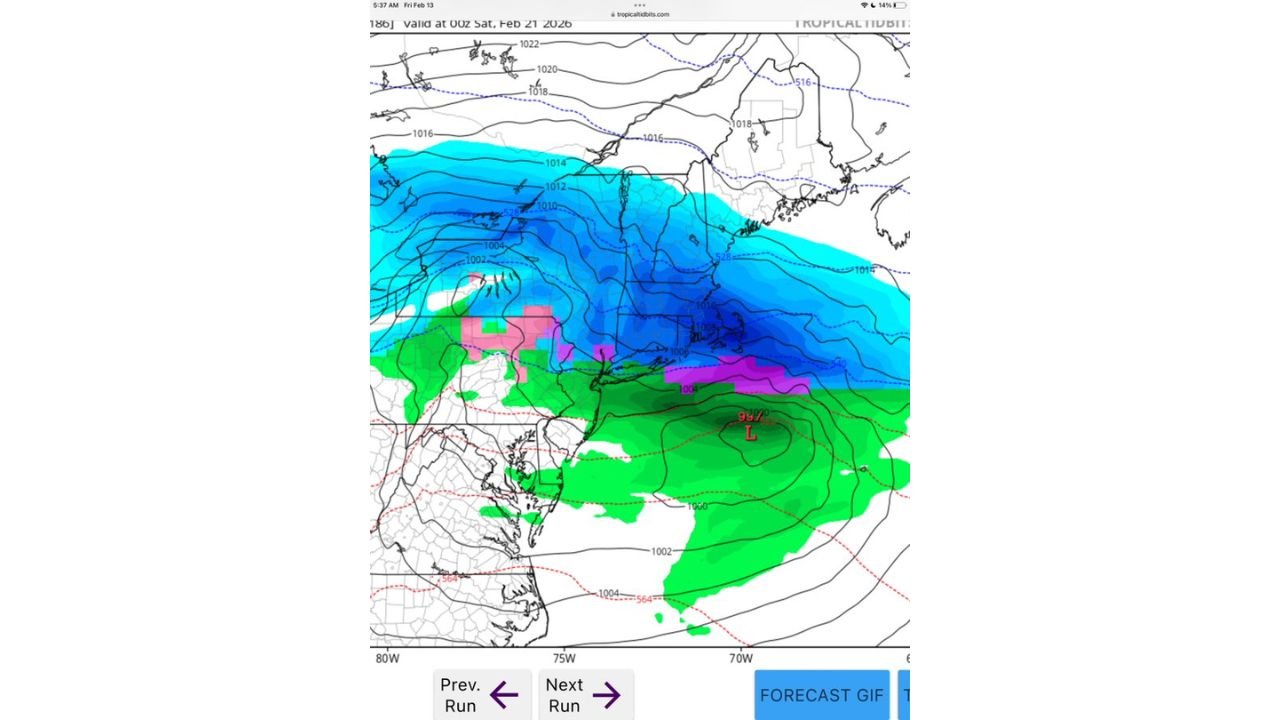
While it is still more than a week away and confidence remains low, the 6z GFS run valid early February 21 depicts a developing low-pressure system off the Mid-Atlantic coast that could spread precipitation across New York and New England.
What the Current GFS Run Shows
The model map indicates a surface low positioned southeast of Long Island, with pressure falling into the upper 990s millibars. The precipitation shield extends northward across:
- Southern and central New York
- Connecticut
- Rhode Island
- Massachusetts
- Portions of Vermont, New Hampshire, and Maine
Precipitation type varies significantly depending on location.
Snow Potential
Colder air north of the low supports snow across:
- Interior New York State
- The Hudson Valley
- Much of Vermont and New Hampshire
- Interior Maine
The deeper blues on the model indicate accumulating snowfall potential, particularly away from the immediate coastline.
Mixed Precipitation and Rain Zones
Closer to the coastal low, the model suggests:
- A transition zone of mixed precipitation (pink shading) near parts of southern New England
- Rain across coastal areas, including parts of Long Island and southern Connecticut
Warmer air wrapping around the coastal low keeps the immediate shoreline more likely to see rain or a wintry mix under this solution.
Track and Strength Still Uncertain
The depicted low is centered offshore, but small changes in track could dramatically alter impacts.
If the storm tracks:
- Farther offshore: Snow would likely remain confined to interior areas
- Closer to the coast: Snow potential could expand south and east
- Farther inland: Warmer air could limit snowfall across much of southern New England
At this range, even a shift of 50–100 miles can significantly change snowfall placement.
Agreement Between GFS and CMC
The key takeaway is that both the GFS and CMC are showing a system during this timeframe. While exact placement and intensity differ, the fact that multiple global models are signaling development increases interest in the pattern.
However, ensemble support and consistency over the next several runs will be critical before confidence increases.
What Residents Should Watch
For areas including:
- Albany
- Hartford
- Boston
- Providence
- Burlington
- Portland, Maine
The main questions remain:
- Will cold air be deep enough for snow at lower elevations?
- How close to the coast will the low track?
- Will this system strengthen or weaken in future runs?
At this stage, this is simply an early signal — not a confirmed storm.
Bottom Line
A week out, both the GFS and CMC are hinting at a late-week coastal storm that could bring a mix of rain and snow to parts of the Northeast.
Interior New York and northern New England appear to have the highest early snow potential, while coastal southern New England may contend with rain or mixed precipitation.
Model volatility is high at this lead time, and significant changes are likely.
WaldronNews.com will continue monitoring upcoming model runs to determine whether this signal strengthens into a credible late-week winter threat.