
GFS Shows Major 6–12 Inch Snowstorm From Washington, D.C. to Boston While European Model Paints Much Lighter Totals, Setting Up High-Stakes Forecast Battle
WASHINGTON, D.C. — With just two days to go before a potential Northeast winter storm, forecast models remain sharply divided — and the difference could mean the contrast between a major snow event and a near-miss for millions along the I-95 corridor.
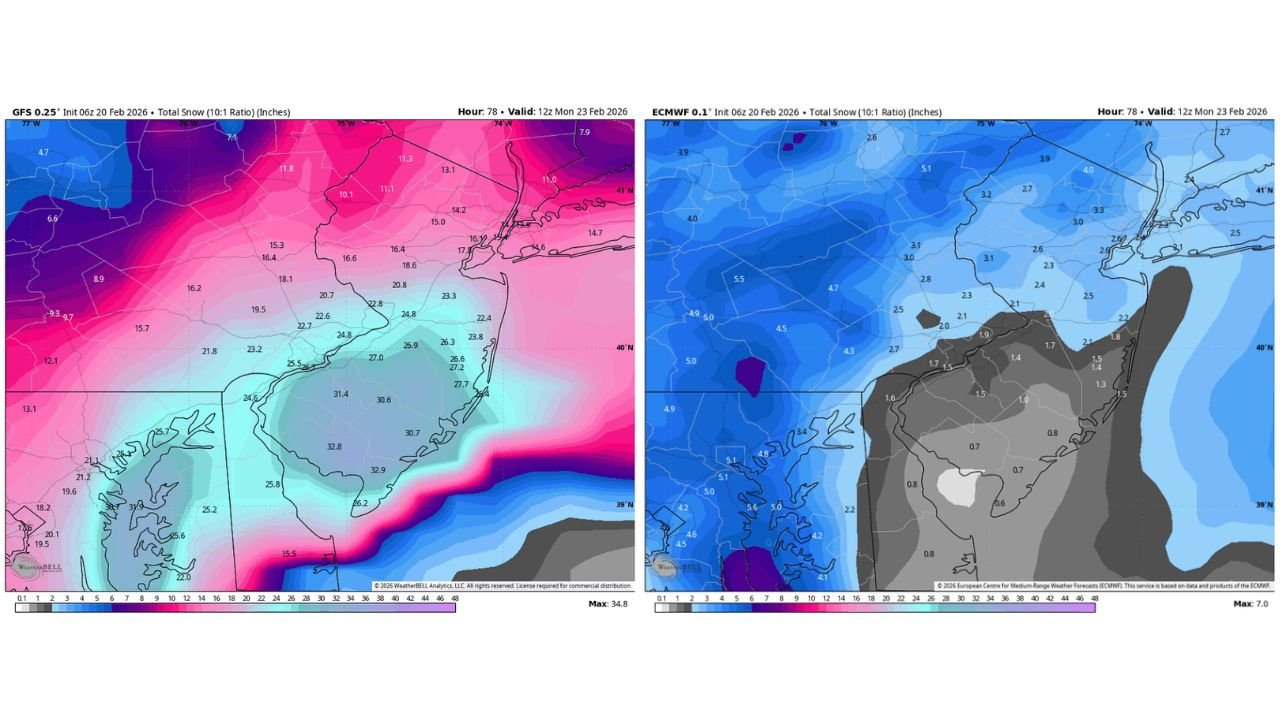
New data from the U.S. GFS model continues to depict a significant snowstorm stretching from Washington, D.C., through Baltimore, Philadelphia, New York City, and up to Boston, while the European (ECMWF) model shows dramatically lighter totals across much of the same region.
GFS Projects Widespread 6–12 Inches, Locally Higher
The latest GFS 0.25° snowfall map valid midday Monday shows a broad swath of 6 to 12 inches, with localized totals pushing into the mid- to upper-teens in parts of:
- Eastern Pennsylvania
- Northern New Jersey
- Southern New York State
- Interior Connecticut and Massachusetts
Across Washington, D.C. and much of central Maryland, the GFS indicates widespread double-digit totals, with some zones in Maryland and northern Virginia exceeding 15 inches. Farther north into New York City and southern New England, projected totals generally range between 8 and 15 inches depending on exact band placement.
The model’s depiction suggests a classic coastal storm scenario with strong deformation banding setting up inland while heavier precipitation remains just offshore along the Mid-Atlantic coast.
European Model Paints Much Lighter Outcome
In sharp contrast, the ECMWF 0.1° snowfall output for the same valid time shows a far weaker and more offshore solution. Snowfall totals in the Euro guidance are largely confined to:
- Western and central Pennsylvania (generally 3–6 inches)
- Portions of upstate New York
- Limited accumulations near the Appalachians
Meanwhile, much of the Washington, D.C. metro, Baltimore, Philadelphia, New York City, and coastal New England show only light snowfall — in many cases under 2 inches.
The difference is dramatic: the GFS suggests a disruptive snowstorm for major population centers, while the Euro implies a lower-impact event with most heavier snow staying west of the I-95 corridor.
Why the Model Disagreement Matters
At this stage — roughly 48 hours out — such a large disparity between major global models is notable. The storm track and intensity appear to be the main points of contention:
- The GFS solution strengthens the coastal low more aggressively and tucks it closer to the shoreline, allowing heavier snow bands to push inland.
- The Euro solution keeps the low weaker and farther offshore, limiting moisture and snowfall across the urban corridor.
Even a shift of 50–75 miles in storm track could dramatically alter final snowfall totals in cities like D.C., Philadelphia, New York, and Boston.
Model Performance Debate Adds to Stakes
Accompanying anomaly correlation data (500mb height verification scores) shows the European model maintaining slightly higher consistency scores compared to the GFS over recent forecast cycles. While both models generally perform well, the ECMWF often edges out the GFS in medium-range verification statistics.
However, it’s worth noting that model performance varies by pattern, and individual storm setups can favor one solution over another. Forecasters are closely monitoring trends in upcoming runs to see whether the guidance begins to converge.
What Happens Next?
Over the next 24 hours, short-range guidance and ensemble trends should begin narrowing the gap. Key factors forecasters are watching include:
- Strength and positioning of the coastal low
- Interaction with upper-level energy
- Placement of the rain/snow line near the Mid-Atlantic coast
- Development of mesoscale banding features
If the GFS verifies, significant travel disruptions could occur from Washington, D.C. through Boston Sunday night into Monday. If the Euro is correct, impacts would be far more limited for major East Coast cities.
With the clock ticking, residents along the I-95 corridor should monitor updates closely. Forecast adjustments are likely as models refine the storm’s exact track and intensity.
Stay with Waldronnews.com for continuing updates as this high-stakes winter forecast battle unfolds.