
Great Lakes, Northern Mid-Atlantic, and Southern New England to See Dangerous Winter Mix With Freezing Rain, Sleet, Snow, and Power Outage Risk
GREAT LAKES — A broad, slow-moving storm system is creating dangerous winter travel and utility risks across the Great Lakes, Northern Mid-Atlantic, and Southern New England, where freezing rain, sleet, and snow are impacting roads and infrastructure from Friday into early Saturday.
Forecast guidance and weather-service outlooks show a wintry mix zone stretching from the western Great Lakes eastward through parts of Michigan, Ohio, Pennsylvania, New York, New Jersey, Maryland, northern Virginia, Connecticut, Rhode Island, and Massachusetts. The most significant hazards are expected south of the heaviest snow band, where ice accretion is likely.
Ice and Mixed Precipitation Creating the Highest Risk
The primary concern for this region is freezing rain and sleet, especially during overnight and early-morning periods when surface temperatures remain below freezing while warmer air rides overhead.
- Ice accumulation may coat untreated roads, bridges, sidewalks, and power lines
- Tree damage is possible where ice loads combine with gusty winds
- Power outages could occur in pockets with heavier icing
Weather outlooks highlight northern Ohio, southern Michigan, central and eastern Pennsylvania, northern New Jersey, the Hudson Valley, and interior New England as areas where ice impacts could be most disruptive.
Snow Adds to Travel Trouble Near the Great Lakes
Colder air on the north and west side of the system is producing periods of snow, especially near the Great Lakes and higher elevations inland.
- Snow and sleet accumulation may reduce visibility
- Lake-enhanced snowfall could locally increase totals
- Slushy, snow-covered roads may transition quickly to ice
Even lighter snow amounts become hazardous when layered over freezing rain.
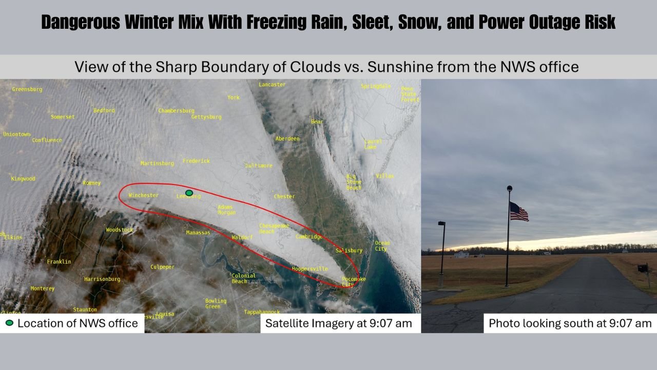
Sharp Weather Boundaries Complicate Forecast
Satellite imagery from National Weather Service offices shows sharp boundaries between cloud cover and breaks of sunshine, a sign of complex temperature gradients in the atmosphere. These boundaries make it difficult to pinpoint exactly where snow changes to sleet or freezing rain, increasing uncertainty at a local level.
Residents may experience very different conditions over short distances, particularly from north to south.
Travel and Safety Concerns
Officials urge caution across the region as road conditions may deteriorate rapidly, especially after sunset.
Drivers should be prepared for:
- Icy highways and secondary roads
- Reduced visibility during snow or sleet
- Downed tree limbs or power lines
Those traveling overnight or early Saturday should check local advisories and road conditions before departing.
What to Expect Next
Conditions are expected to gradually improve from west to east as the system moves offshore by Saturday, though lingering icy spots may persist in shaded or untreated areas.
While this is considered a secondary but significant winter event, its mixed precipitation nature increases the potential for dangerous impacts disproportionate to snowfall totals.
Stay alert, monitor local weather updates, and take precautions if travel is necessary. For continuing coverage of regional weather threats and safety updates, visit WaldronNews.com and share how conditions look in your area.