
Great Lakes States See Widespread Early-Season Snow Cover as December Winter Pattern Takes Hold
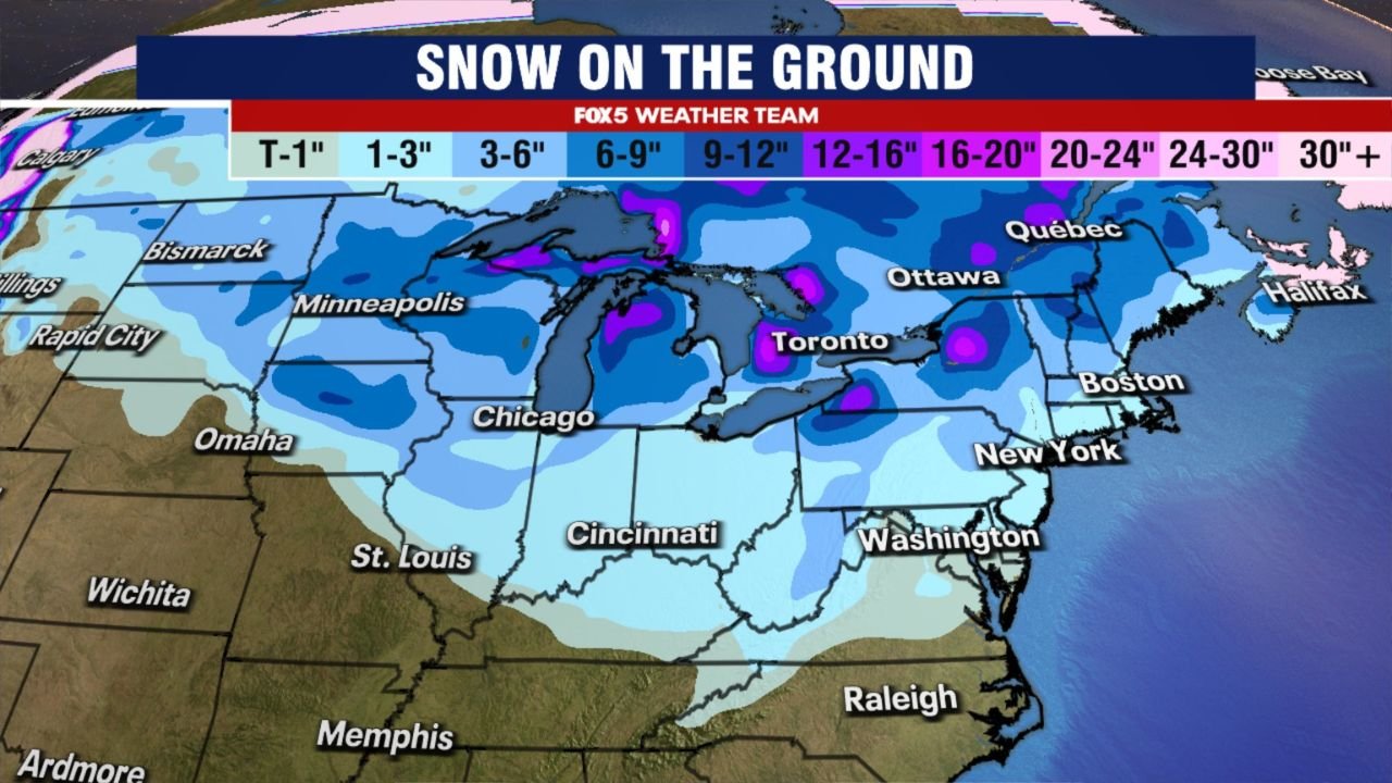
UNITED STATES — A broad and unusually early snow cover has settled across the Great Lakes region, with Michigan, Wisconsin, Minnesota, northern Illinois, and parts of Ohio and New York already seeing measurable snow on the ground by mid-December. Snow-cover analysis shows this region standing out as one of the most consistently snow-covered areas in the eastern half of the country so far this season.
The extent of snow coverage highlights a colder-than-average early December pattern, allowing snow to accumulate and remain rather than melt between systems.
Upper Midwest and Great Lakes Among the Most Snow-Covered Areas
Snow-on-the-ground maps show continuous snow cover stretching from Minnesota through Wisconsin and Michigan, extending into northern Illinois, Indiana, Ohio, and western New York.
Key observations from the data include:
- Several inches of snow on the ground across much of Minnesota and Wisconsin
- Deeper snow pockets near Lake Superior and Lake Michigan
- Persistent coverage across interior sections of Michigan
- Light to moderate accumulation extending southward into the Midwest
Lake-effect processes have helped reinforce snow depth in favored areas, especially downwind of the Great Lakes.
Lake-Effect Snow Playing a Major Role
The presence of relatively warm lake waters compared to incoming cold air has contributed to repeated lake-effect snow events, particularly in:
- Northern Michigan
- Western and northern New York
- Parts of Wisconsin
These localized but frequent snow bursts have helped maintain snowpack, even in areas that have not seen major winter storms.
As cold air continues to pass over the lakes, snow cover has expanded rather than retreated.
Early Snow Coverage Stands Out Compared to Recent Years
In many recent winters, Great Lakes snow cover has been slow to establish, with December often dominated by rain or brief snow followed by melting.
This season is different.
The current pattern has allowed:
- Snow to fall early
- Cold temperatures to lock it in place
- Minimal thawing between systems
This has resulted in more extensive and longer-lasting snow on the ground compared to several recent Decembers.
Why Early Snow Cover Matters Going Forward
Early-season snow cover can influence weather patterns by:
- Reinforcing colder surface temperatures
- Increasing the chance that future systems produce snow instead of rain
- Enhancing lake-effect potential
While early snow does not guarantee a severe winter, it raises the likelihood that upcoming systems will maintain wintry impacts, especially across the Great Lakes corridor.
What to Watch Next
With snow already established, residents should continue monitoring:
- Additional lake-effect snow events
- Temperature trends that could either preserve or erode snowpack
- Future storm systems that could build on existing accumulation
Even modest snowfall events can have outsized impacts when snow is already on the ground.
WaldronNews.com will continue tracking snow cover trends and winter developments across the Great Lakes and Midwest.
If your area has snow on the ground this December, share your local conditions with WaldronNews.com to help document this early-season winter pattern.