
Greenville, Spartanburg, Asheville, Charlotte, and Upstate Carolinas Warm Slightly but Stay Below Normal as Nighttime Refreeze Raises Black Ice Risk
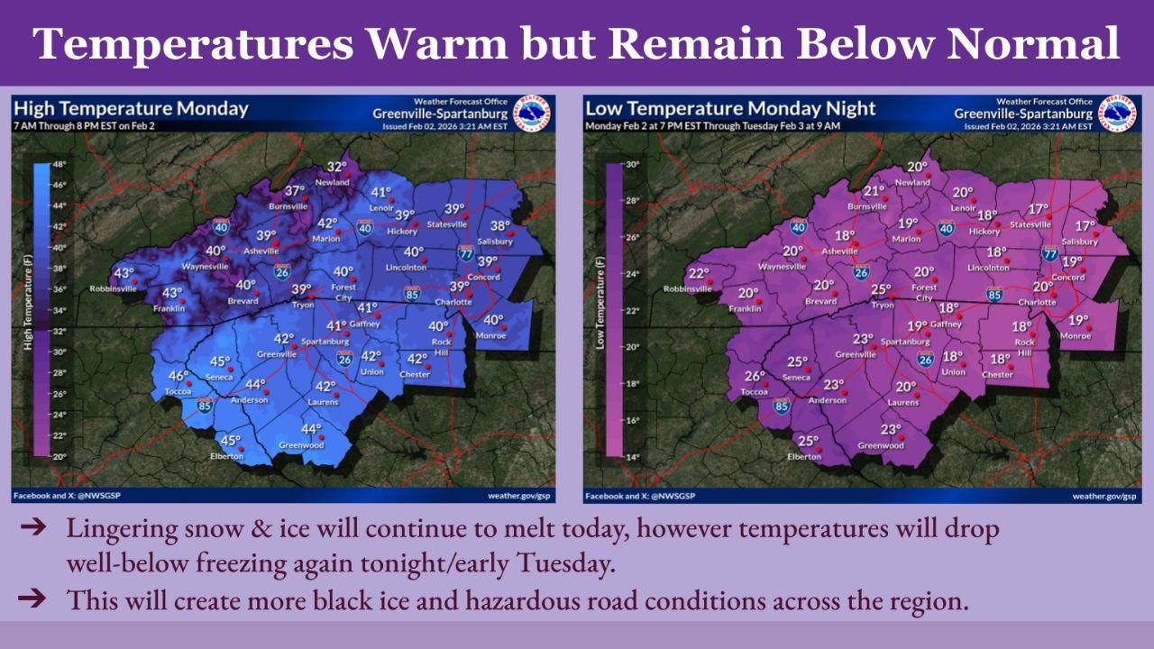
UNITED STATES — A gradual warming trend is underway across the Upstate of South Carolina and western North Carolina, but temperatures are expected to remain below early-February normals over the next few days, according to data from the National Weather Service office in Greenville-Spartanburg.
While daytime highs are inching upward, cold nighttime lows will continue to refreeze melting snow and ice, increasing the risk of black ice and hazardous travel, especially during the overnight and early morning hours.
Daytime Highs Improve but Remain Subpar for Early February
High temperature data for Monday shows most communities reaching the upper 30s to mid-40s, offering modest relief after recent cold.
Observed and forecast highs include:
- Asheville: around 40°F
- Greenville: near 42°F
- Spartanburg: around 41°F
- Charlotte: close to 40°F
- Hickory and Lenoir: upper 30s
- Anderson and Greenwood: mid-40s
Despite the warming, these values remain below normal for early February, limiting how much snow and ice can fully melt during the day.
Temperatures Drop Sharply Monday Night
Overnight conditions reverse quickly, with lows falling well below freezing again Monday night into early Tuesday.
Forecast low temperatures include:
- Asheville: around 18°F
- Greenville: near 23°F
- Spartanburg: around 23°F
- Charlotte: close to 20°F
- Hickory: near 18°F
- Rock Hill and Chester: upper teens
Mountain locations and sheltered valleys are expected to cool fastest, increasing the likelihood of refreezing.
Melting by Day, Refreezing by Night Raises Black Ice Concern
Forecasters warn that lingering snow and ice will melt during daylight hours, but the sharp temperature drop overnight will allow water to refreeze on roadways, bridges, and sidewalks.
This freeze-thaw cycle is expected to create additional black ice, particularly in shaded areas and on secondary roads across the region.
Warming Trend Continues, But Cold Lingers
Although temperatures are forecast to gradually moderate over the coming days, the air mass remains cold enough to keep overnight lows below freezing, prolonging hazardous travel conditions.
Officials urge drivers to remain cautious during the late night and early morning commute periods, when refreezing is most likely.
Stay with Waldronnews.com for continued updates on temperature trends, road conditions, and winter weather impacts across the Carolinas and the United States.