
Guam, Alaska, and Northern United States Face Late April Weather Shift Risk as Tropical Storm Sinlaku May Amplify Jet Stream and Drive Strong Cold Fronts
UNITED STATES — A developing tropical system in the western Pacific is now drawing attention not just for its potential impact near Guam, but for what it could mean for the broader weather pattern across the United States later this month.
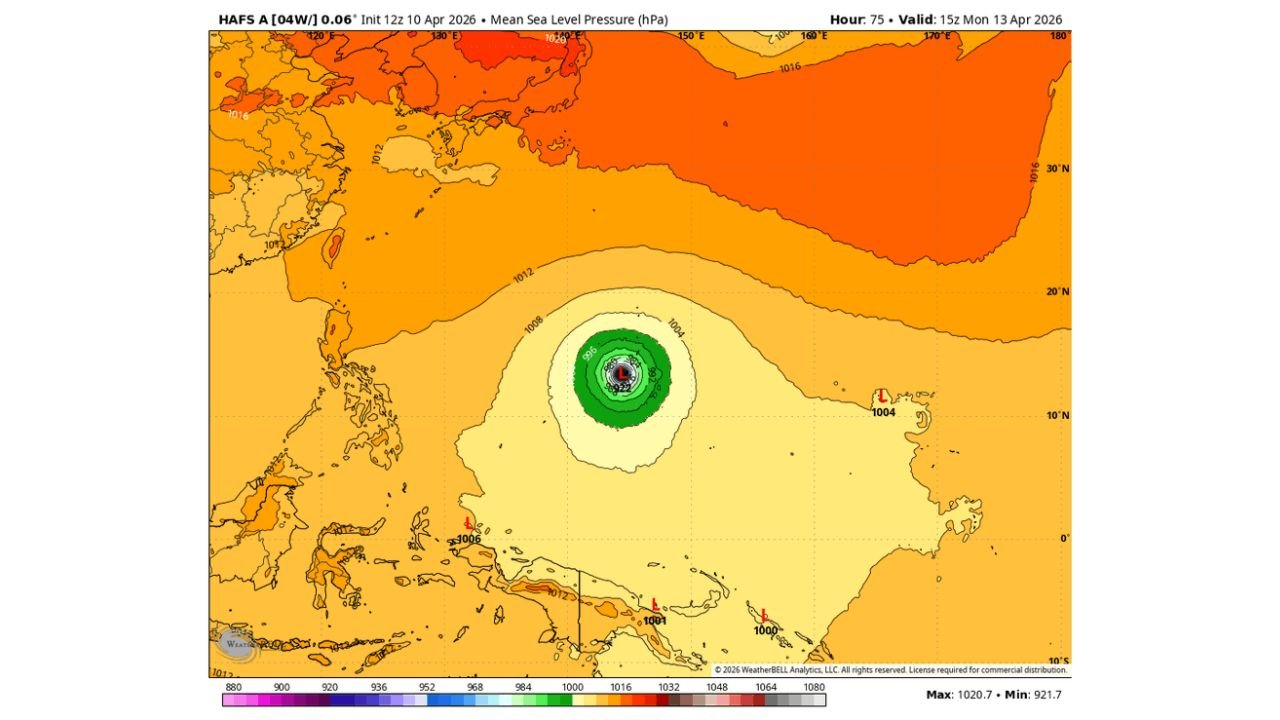
Tropical Storm Sinlaku Could Become a Major Threat Near Guam
Current projections indicate that Tropical Storm Sinlaku could strengthen significantly over the coming days as it moves across the western Pacific. Forecast models show a well-organized system with a clear track, suggesting the potential for this storm to become a major typhoon.
Guam is currently one of the areas that could face impacts within the next several days, depending on how the storm evolves.
Long-Range Track Shows Northward Turn Toward Alaska Region
Ensemble model guidance shows a consistent northward curve in the storm track, with the system expected to move away from the tropics and head toward the northwestern Pacific and eventually the Alaskan region over the next 10 to 14 days.
This type of movement is critical because it places the storm in a position to interact with larger atmospheric patterns.
Possible Jet Stream Interaction Could Shift U.S. Weather
As the system moves north, forecasts suggest it could be “flung” into the jet stream near Alaska, which may lead to:
- Amplification of the jet stream pattern
- Increased energy feeding into North America’s weather system
- Development of a stronger cold front moving into the northern and eastern United States
This kind of interaction often leads to more dramatic weather changes, even far away from the original storm.
Late April Pattern Change Possible Across Northern and Eastern U.S.
If the projected setup holds, the end of April could feature:
- A more active and amplified weather pattern
- Potential for stronger cold fronts
- Increased chances of storm systems across the northern and eastern U.S.
While exact impacts remain uncertain at this stage, the connection between Pacific systems and U.S. weather patterns is well-established in long-range forecasting.
Why This System Matters Beyond the Tropics
Unlike typical storms that remain isolated to one region, Sinlaku has the potential to:
- Influence large-scale atmospheric flow
- Affect weather thousands of miles away
- Contribute to pattern shifts rather than just local impacts
This makes it a system that forecasters will continue monitoring closely over the coming days.
What to Watch Next
- Strength and track changes near Guam
- Timing of the northward turn
- Interaction with the jet stream near Alaska
- Signs of a pattern shift over the United States by late April
Forecast confidence will increase as the storm develops further, but early signals already point to a system that could have far-reaching impacts beyond the Pacific.
Stay with WaldronNews.com for continued updates as Tropical Storm Sinlaku evolves and its potential influence on U.S. weather becomes clearer.