
Gulf Coast Braces for Torrential Downpours and Thunderstorms Wednesday Night into Early Thursday
Louisiana — A powerful storm system is expected to bring intense rainfall, rumbles of thunder, and localized flooding across the Gulf Coast beginning late Wednesday night and continuing through early Thursday morning. Meteorologists warn that the atmosphere will turn increasingly unstable, with conditions ideal for a dramatic round of heavy rain and thunderstorms stretching from Lake Charles and Baton Rouge to New Orleans and the Mississippi Gulf Coast.
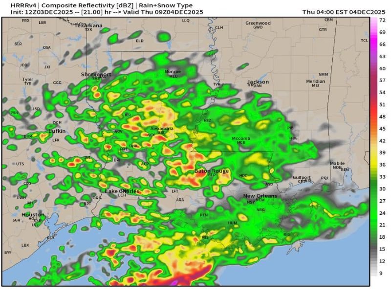
Storms Building Overnight Across Louisiana and Mississippi
Forecast models, including the latest HRRR composite reflectivity data, show widespread rain bands developing by midnight, with areas of enhanced rainfall over southern Louisiana. The most intense activity is expected between 2 a.m. and 6 a.m. Thursday, when clusters of storms could bring torrential rain and frequent lightning across much of the coast.
By early morning, heavy rain will spread into southern Mississippi, Mobile, and Gulfport, with radar projections suggesting rainfall rates strong enough to cause temporary street flooding. Thunderstorms may also produce gusty winds and isolated power outages in vulnerable areas.
Dramatic Conditions Described by Weather Analysts
Weather analysts, including Weather After Dark, describe the event as “wet, loud, dramatic, and very, very wet,” noting that Mother Nature seems ready to unleash her pent-up energy across the region. The report vividly compares the overnight storms to a “Gulf Coast energy surge” — with lightning flashing like camera lights and thunder rumbling in waves through the early hours.
By Thursday morning, much of the Louisiana and Mississippi coastlines will have received several inches of rain. Drivers should expect ponding on roads, slick highways, and longer commute times as the heaviest bands pass through during peak travel hours.
Flooding and Safety Concerns for the Gulf Coast
The National Weather Service warns that saturated ground from earlier rainfall could worsen localized flooding in low-lying areas and near creeks or drainage zones. Residents are urged to avoid driving through flooded roads, secure outdoor objects, and keep an eye on lightning activity overnight.
Those in Baton Rouge, New Orleans, Alexandria, and Lake Charles should prepare for possible power interruptions and brief periods of strong wind gusts as the storms move through.
Looking Ahead
Rainfall is expected to gradually taper off by Thursday afternoon, though lingering showers and cloud cover may persist across portions of southern Louisiana and Mississippi. Temperatures will remain mild but humid in the system’s wake.
Residents along the Gulf Coast should stay tuned to WaldronNews.com for continued updates on this developing system, potential flash flooding alerts, and regional weather advisories through Thursday morning.