
Heavier Snow Bands Target Greensburg, Indiana as Ohio River Snowfall Intensifies Overnight
GREENSBURG, INDIANA — Snowfall is already ramping up north of Greensburg, Indiana, and meteorologists say the region is entering the more intense phase of this winter storm as heavier snow bands organize along and just north of the Ohio River overnight.
As of 9:07 p.m. EST, 0.6 inches of snow had already been measured north of Greensburg, confirming that the storm is progressing on schedule and that accumulation rates are increasing as colder air deepens across southeast Indiana.
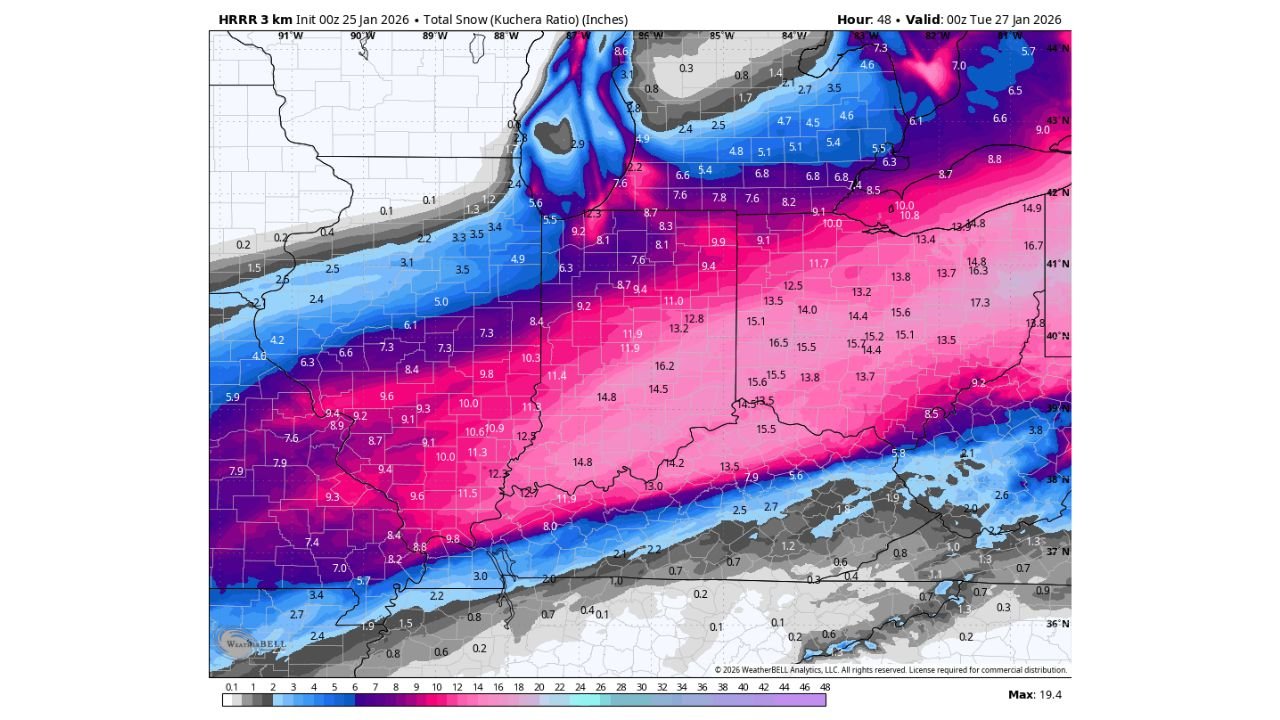
High-resolution HRRR model guidance shows the heaviest snowfall axis sharpening overnight, placing Greensburg and surrounding Decatur County directly within a strengthening snow band capable of producing steady, efficient accumulation through the late night and early morning hours.
Heavier Banding Expected to Develop Overnight
Radar trends and short-range modeling indicate that frontogenetic forcing along the Ohio River corridor will intensify overnight, allowing snowfall rates to increase as mesoscale banding sets up.
This type of banding is critical because it allows snow to accumulate faster than typical stratiform precipitation. Within these bands, snowfall rates can briefly exceed 1 inch per hour, especially where lift and moisture overlap most efficiently.
For Greensburg, this means the storm’s most impactful period is still ahead.
HRRR Snowfall Totals Support Continued Accumulation
The latest HRRR 3-km total snowfall output shows double-digit snowfall potential just south of Greensburg, with solid mid-range totals extending northward into southeast Indiana.
While exact totals can still vary depending on band placement, the data strongly supports that Greensburg is well on track to reach its forecast accumulation, with additional snow expected through the overnight hours as the deformation zone remains locked in place.
Snowfall amounts are likely to increase steadily rather than taper off quickly, especially if the heaviest band remains anchored near the Ohio River longer than expected.
Why Snowfall Efficiency Is Increasing Now
Several factors are coming together to boost snowfall efficiency overnight:
- Colder air deepening through the column, improving snow ratios
- Strong lift within the mid-levels, enhancing crystal growth
- Persistent moisture feed along the frontal boundary
- Reduced mixing, allowing snow to accumulate undisturbed
This setup favors consistent accumulation rather than brief bursts, which is why totals can climb faster late at night than earlier in the evening.
Travel and Overnight Impacts for Greensburg Area
With temperatures remaining cold and snowfall rates increasing, road conditions are expected to deteriorate overnight, especially on untreated secondary roads and rural routes north of Greensburg.
Visibility may also briefly drop within heavier bands, creating hazardous travel conditions for overnight drivers and early-morning commuters.
Residents should expect snow-covered roads by morning, even in areas that initially saw slower accumulation.
What Happens Next
Snow is expected to continue through the overnight period before gradually easing as the main forcing shifts east. However, lingering light snow and blowing snow may persist into the early morning hours.
Officials will continue monitoring band placement closely, as even small shifts can locally increase totals.
Stay with WaldronNews for real-time snowfall updates, overnight accumulation reports, and early-morning impact coverage for Greensburg and southeast Indiana. If you’re seeing snow totals in your area, share them with us — local reports help keep our coverage accurate and focused.