
Heavy Rain and Street Flooding Threat Targets South Florida This Weekend — Miami, Palm Beach and Broward Counties on Alert for Sunday Downpours
MIAMI, FLORIDA — A frontal system is set to dig into South Florida late Saturday into Sunday morning, bringing multiple rounds of heavy showers and thunderstorms to one of the state’s most densely populated corridors. Rain probabilities are jumping between 50% and 70% across the region, with some neighborhoods expected to see just over an inch of rainfall — and localized areas could see significantly more thanks to a powerful coastal convergence setup along the southeast Florida coastline.
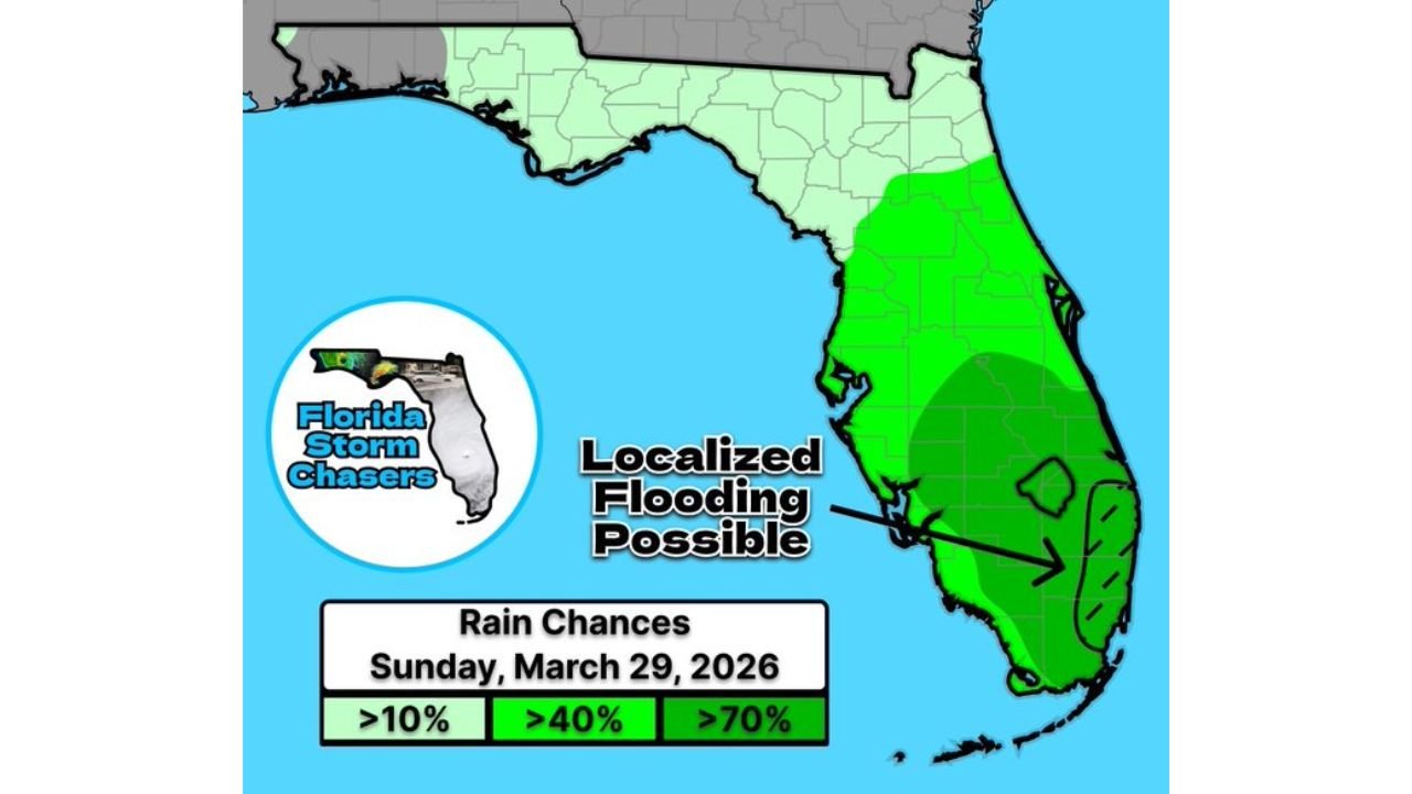
The event is timed to impact Sunday, March 29, 2026, with storms arriving and departing at irregular intervals throughout the day on an active easterly onshore breeze.
Counties and Areas in the Risk Zone
The heaviest rainfall threat is concentrated across southeast Florida’s most populated counties:
- Miami-Dade County: Highest flood risk, greatest rain probability exceeding 70%, localized street flooding possible
- Broward County: Heavy shower and thunderstorm threat throughout Sunday, coastal convergence a key driver
- Palm Beach County (metro): Multiple rounds of rain expected, rainfall totals near or just over 1 inch in select areas
- Port Saint Lucie / Treasure Coast: lighter rain chances on the northern fringe of the system
- Downtown Miami / Bayfront Park: Directly in the path of Sunday’s downpours
Rain chances drop sharply north of the Palm Beach and Treasure Coast area, with central and north Florida seeing only isolated activity.
Primary Threats on Sunday
Forecasters and multiple weather models are pointing to several hazards across South Florida:
- Heavy rainfall totals of 1.1 to 1.3 inches in the highest-risk corridors, with a maximum of up to 1.92 inches in isolated cells (NOAA Blend of Models)
- Localized street flooding in low-lying neighborhoods, particularly across Miami-Dade, Broward and Palm Beach counties
- Coastal convergence enhancement — easterly onshore flow forcing air upward will significantly boost rainfall rates within select storm cells
- Intermittent heavy downpours that arrive at any time throughout Sunday with little warning
- Reduced visibility and hazardous driving conditions during the heaviest rain bursts
Why This Setup is Especially Concerning for Miami-Dade
The ECMWF European model initialized Friday afternoon shows the most intense precipitation rates concentrated squarely over Miami and surrounding areas by 2 p.m. Sunday. A prominent easterly onshore breeze pushing moisture inland across metro Palm Beach, Broward and Miami-Dade counties creates a classic coastal convergence pattern — air forced upward along the convergence zone dramatically enhances rainfall intensity within individual storm cells.
This means that even neighborhoods that avoid the heaviest cores could still see rapid water accumulation as the frontal system interacts with the warm, moisture-laden Atlantic air mass parked just offshore.
Residents of downtown Miami should take particular note — Day 3 of the Ultra Music Festival at Bayfront Park falls directly within this weather window. Attendees are strongly advised to bring an umbrella and poncho and prepare for wet conditions throughout the day.
Multi-Day Pattern: Frontal Activity Continues
This weekend’s system is part of a broader pattern of active frontal passages affecting Florida over the coming days. Multiple disturbances tracking across the Southeast mean that South Florida may not get a prolonged break between rain events. With soils potentially saturated from successive rainfall events, even moderate additional rainfall could quickly lead to standing water and localized flooding in vulnerable low-lying areas across Miami-Dade and Broward counties.
What to Watch Next
As Sunday approaches, key details to monitor include:
- Exact storm timing — downpours could arrive any time throughout the day
- Rainfall totals in individual neighborhoods, especially in Miami-Dade County
- Street flooding reports across low-lying areas of Miami, Fort Lauderdale and West Palm Beach
- Coastal convergence development and whether it amplifies storm intensity beyond current forecasts
- Festival and outdoor event impacts across downtown Miami and Bayfront Park
Residents across South Florida should keep weather alerts enabled on mobile devices, avoid driving through flooded roadways, and have rain gear ready for any outdoor plans this Sunday.
WaldronNews.com will continue tracking this frontal system and provide updated rainfall and flooding information as forecasts are refined ahead of Sunday’s event.