
Heavy Snow Bands Target North Carolina, South Carolina, and Southern Virginia as NWS Snow Totals Signal Significant Weekend Winter Storm
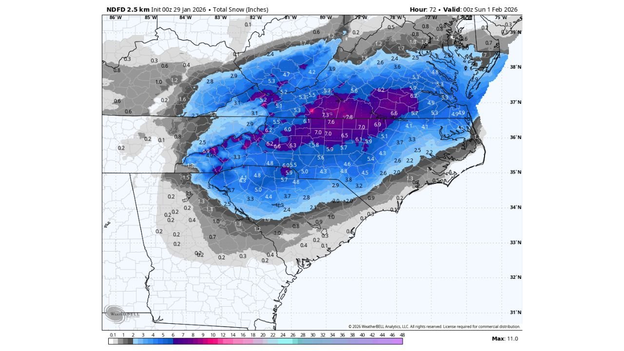
UNITED STATES — The latest National Weather Service (NWS) NDFD total snowfall output shows a high-impact winter storm increasingly likely across North Carolina, South Carolina, and southern Virginia this weekend, with widespread moderate to heavy snow already indicated even before the full event is captured in the data.
Importantly, the current snowfall projection only extends through 7 p.m. Saturday, meaning additional accumulation is likely after this cutoff, especially as the storm continues into Saturday night and early Sunday.
Widespread 4–8 Inch Snowfall Signal Emerging
According to the most recent NDFD snowfall guidance:
- A broad swath of 4 to 7 inches of snow is already depicted across central North Carolina
- Portions of eastern North Carolina into southern Virginia show 6 to near 8 inches
- Inland sections of South Carolina, particularly north and central areas, show 3 to 6 inches
- Higher localized totals appear embedded within the heavier snow band
Several areas within the core band already exceed 7 inches before the full duration of the storm is included, underscoring the potential for higher final totals.
Snow Totals May Increase as Event Continues Beyond Model Cutoff
Forecasters stress that these totals do not represent the entire storm.
- The data ends at 7 p.m. Saturday
- Snow is expected to continue Saturday night into early Sunday
- High snow-to-liquid ratios suggest snowfall may accumulate efficiently
Because of these factors, final storm totals may exceed current projections, particularly where persistent snow bands remain stationary.
Heavy Snow Focused Inland, Coastal Totals Still Uncertain
At this time:
- The highest confidence for heavy snow remains inland across the Carolinas and southern Virginia
- Coastal snowfall is not fully resolved yet
- Additional guidance on coastal impacts is expected with upcoming updates
This introduces the possibility that coastal areas could see more snow than currently shown, depending on storm track and mesoscale banding.
A Rare, High-Confidence Winter Storm Setup
The overall pattern continues to favor a cold, snow-dominant system, rather than a mixed precipitation event.
- Thermal profiles strongly support all snow
- Snowfall efficiency appears high
- Forecast confidence continues to increase rather than decrease
This combination raises concern for travel disruptions, power outages, and prolonged impacts, particularly if higher totals verify.
What Happens Next
Forecasters expect additional refinement in snowfall totals as the full event window comes into range, including:
- Expanded NDFD updates
- Coastal snowfall clarity
- Finalized accumulation forecasts
WaldronNews Weather Alert
A significant winter storm is increasingly likely across North Carolina, South Carolina, and southern Virginia this weekend, with heavy snow already indicated before the full storm duration is included in model output.
Residents should begin preparing now and continue monitoring updates.
Stay with WaldronNews for ongoing winter storm coverage, refined snowfall totals, and impact-focused updates as new data becomes available.