
Idaho Sees Rare December Severe Thunderstorm With Mesovortices and 80-MPH Winds Triggering Warnings Across Eastern Idaho
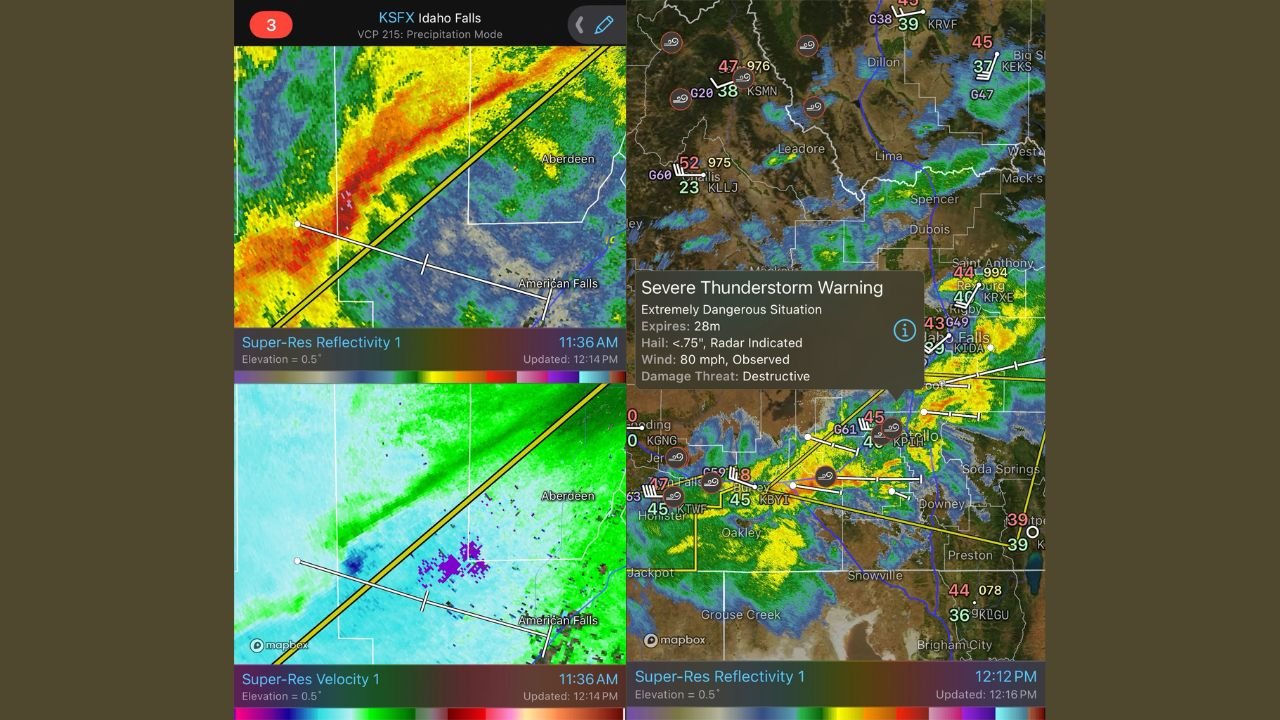
IDAHO — A rare and unusually intense December severe thunderstorm swept across parts of eastern Idaho on Wednesday, producing damaging wind gusts up to 80 mph, radar-confirmed mesovortices, and prompting the National Weather Service to issue Severe Thunderstorm Warnings labeled an “Extremely Dangerous Situation.” Meteorologists say the setup is highly uncommon for this time of year in the Intermountain West.
The storm complex moved across areas near Idaho Falls, American Falls, Aberdeen, Oakley, and surrounding communities, showing clear signs of organized rotation within the line — a feature more commonly associated with springtime severe weather in the Plains.
Rare December Severe Weather Setup in Idaho
December severe thunderstorms are exceptionally uncommon in Idaho, especially storms capable of producing destructive winds and embedded rotation. Atmospheric data and radar imagery show the storm developed within a strongly sheared environment, allowing small-scale circulations, known as mesovortices, to form within the thunderstorm line.
Mesovortices are brief but intense areas of rotation that can significantly increase wind damage and, in rare cases, lead to short-lived tornadoes. While no confirmed tornado touchdown has been reported, meteorologists noted that radar signatures were strong enough to raise concern and warranted enhanced warnings.
80-MPH Winds Confirmed as Primary Threat
According to warning details displayed on radar platforms, wind gusts around 80 mph were observed, with the National Weather Service identifying the damage threat as “destructive.” Winds of this magnitude are capable of downing trees, snapping large branches, damaging roofs, and causing power outages.
Emergency officials urged residents to remain indoors during the storm’s passage, warning of flying debris and rapidly changing conditions. In several locations, the strongest winds coincided with heavy rain, reducing visibility and increasing travel hazards.
Radar Shows Mesovortices Embedded in Storm Line
High-resolution radar imagery from the Idaho Falls radar site showed tight velocity couplets embedded within the thunderstorm, a clear indication of mesovortex development. These features were most prominent near and west of Idaho Falls as the storm tracked east-northeast.
Meteorologists emphasized that mesovortices can spin up and weaken quickly, making them difficult to detect without advanced radar analysis. Their presence in December underscores just how anomalous the atmospheric setup was.
Why This Storm Stood Out for December
Weather experts pointed to a combination of strong upper-level winds, sufficient instability, and sharp wind shear as the key ingredients behind the storm. While cold-season thunderstorms do occur in the Northwest and Intermountain West, storms capable of producing organized severe wind events are rare, especially this far inland.
The event has already drawn attention from weather analysts who track off-season severe weather, noting that December mesovortices in Idaho are far outside climatological norms.
What Residents Should Know Going Forward
Forecasters continue to monitor the region for additional strong storms as unsettled weather remains possible. Residents are encouraged to stay weather-aware, especially during winter systems that may contain embedded thunderstorms capable of producing sudden high winds.
Anyone who experienced damage is advised to document impacts and report them to local authorities, as post-event analysis helps meteorologists better understand rare severe weather patterns in the region.
WaldronNews.com will continue tracking unusual and impactful weather events across the country. Have photos, videos, or storm damage reports from your area? Share your experience and stay connected with WaldronNews.com for ongoing updates.