
Illinois and Indiana Face Enhanced Tornado Risk as Long-Track Supercells Target Southeast Illinois Into Central Indiana
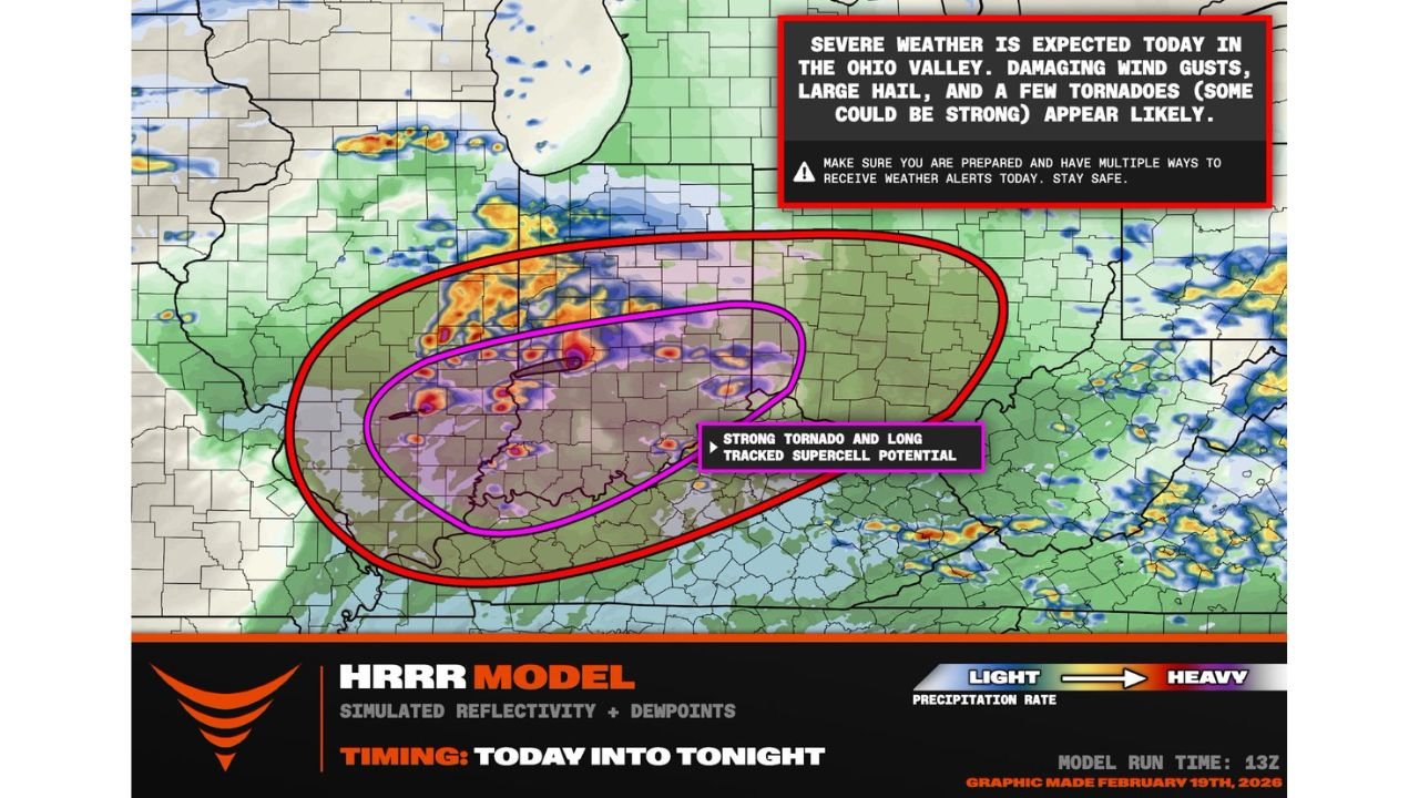
INDIANA — A dangerous severe weather setup is unfolding across the Ohio Valley today, with southeast Illinois into central and southern Indiana now under an enhanced risk for long-track supercells capable of producing a strong tornado.
Latest short-range guidance shows a volatile environment developing from late morning through the evening hours, with storms expected to move west to east between noon and 8 p.m. across the risk zone.
Enhanced Risk Corridor: Southeast Illinois Into Indiana
Model guidance highlights a focused corridor stretching from southern and southeast Illinois through much of central Indiana, including areas near:
- Evansville, IN
- Terre Haute, IN
- Bloomington, IN
- Indianapolis, IN
- Vincennes, IN
- Portions of western and central Kentucky
The highest concern is within the purple-shaded zone shown in the model graphic, where strong tornado and long-tracked supercell potential is specifically indicated.
This is not a broad, low-end setup. The parameters suggest storms could remain organized for extended periods — increasing the threat for tornadoes that stay on the ground longer than typical brief spin-ups.
Why This Setup Is Concerning
New high-resolution model data indicates a large warm sector opening up ahead of an advancing storm system, allowing:
- Dew points climbing into the lower 60s
- A strengthening 50-knot southwesterly low-level jet
- Strong wind shear supportive of rotating supercells
Supercells are expected to fire first across southern Illinois, then track eastward into Indiana, riding the gradient of deeper moisture and instability.
This combination of moisture, wind shear, and timing during peak daytime heating raises the concern for:
- Damaging wind gusts
- Large hail
- Tornadoes, some potentially strong
The threat area also extends into parts of western Ohio and northern Kentucky, though the most intense signal remains centered from Illinois into Indiana.
Timing: Midday Through Evening
Storm initiation is expected as early as midday in Illinois, with activity intensifying and spreading eastward through the afternoon and early evening hours.
The primary severe window appears to be:
- 12 p.m. – 4 p.m. across southeast Illinois
- 3 p.m. – 8 p.m. across central and southern Indiana
Given the west-to-east motion, residents further east should monitor conditions closely through sunset.
Ohio Valley Under Heightened Alert
Forecast messaging clearly states: “Severe weather is expected today in the Ohio Valley. Damaging wind gusts, large hail, and a few tornadoes (some could be strong) appear likely.”
With storms expected to organize quickly and intensify in a supportive environment, residents across the risk area should:
- Have multiple ways to receive warnings
- Review tornado safety plans
- Be prepared to take shelter quickly
Long-track supercell setups are less common but more dangerous, as they can impact multiple counties over extended paths.
Bottom Line
Southeast Illinois and much of Indiana are in a serious severe weather corridor today, with enhanced risk parameters supporting strong tornado potential. Storms will move west to east from midday into tonight.
This is a day to stay weather-aware, especially across central Indiana and southern Illinois where the environment appears most favorable for rotating storms.
WaldronNews.com will continue monitoring the situation and provide updates as watches and warnings are issued.