
Illinois and Indiana Upgraded to Enhanced Risk as SPC Flags 10% Chance of Strong Tornadoes Near Effingham, Mt. Vernon, Vincennes and Bloomington
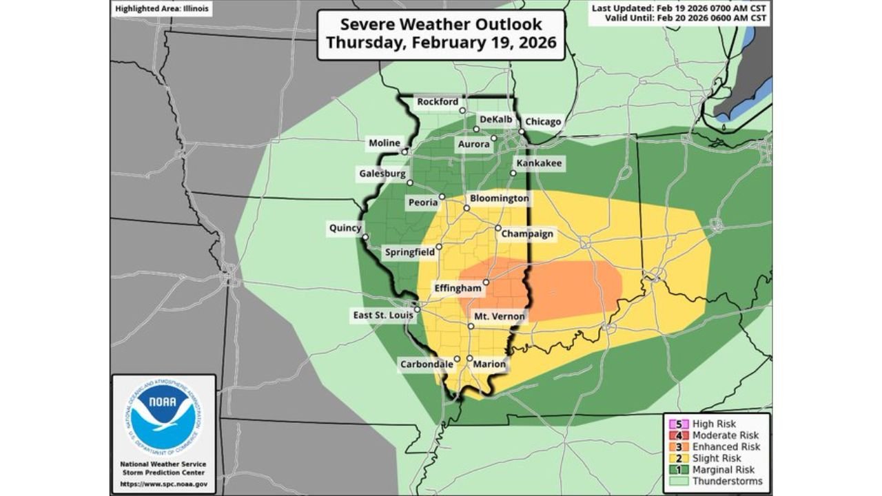
INDIANA — The Storm Prediction Center (SPC) has upgraded portions of central and southern Illinois and southwest Indiana to an Enhanced Risk (Level 3 of 5) for severe weather today, highlighting an increased tornado threat — including the potential for strong tornadoes (EF2 or higher).
The latest outlook shows a 10% probability of a significant tornado within 25 miles of any point in the highlighted hatched area, marking a notable escalation from earlier forecasts.
Enhanced Risk Corridor Expands Across Southern Illinois
The updated severe weather outlook places a Level 3 Enhanced Risk over a broad stretch of southern and east-central Illinois, including:
- Effingham
- Mt. Vernon
- Champaign
- Bloomington
- Areas just east of Springfield
Surrounding this zone is a Slight Risk (Level 2) extending north toward Peoria and into portions of central Illinois.
The orange-shaded Enhanced Risk area indicates a higher concentration of severe storm potential, including damaging winds, large hail, and tornadoes.
10% Strong Tornado Probability Zone Identified
The tornado outlook map highlights a hatched yellow zone across:
- Effingham
- Mt. Vernon
- Eastward toward the Illinois–Indiana border
This hatched region represents a 10% probability of a significant tornado (EF2–EF5) within 25 miles of a location.
That level of probability is notable and signals that atmospheric conditions may support stronger, more organized tornadoes — not just brief spin-ups.
Indiana Also Upgraded: Vincennes to Bloomington at Higher Risk
In southwest and south-central Indiana, the Enhanced Risk includes:
- Vincennes
- Bloomington
- Jasper
- Corydon
- Surrounding counties
Indianapolis and Lafayette remain in a Slight Risk zone, while areas farther north toward South Bend and Fort Wayne are in a Marginal Risk.
The tornado probability map for Indiana also shows a hatched 10% zone stretching from Vincennes eastward toward Bloomington — again signaling the possibility of strong tornado development.
What Level 3 (Enhanced Risk) Means
An Enhanced Risk (Level 3 of 5) indicates:
- Numerous severe storms possible.
- Tornadoes are more likely than in a Slight Risk.
- Some tornadoes could be strong (EF2 or greater).
- Damaging wind and hail threats are elevated.
The jump from Slight to Enhanced reflects increasing confidence in storm organization and severity.
Timing and Preparedness
Storms are expected to develop later today, with the highest tornado threat likely during peak afternoon and evening instability.
Residents in:
- Effingham
- Mt. Vernon
- Champaign
- Bloomington
- Vincennes
- Jasper
- Corydon
should review severe weather safety plans immediately.
Ensure you have:
- Multiple ways to receive warnings.
- A designated shelter location.
- Charged communication devices.
- Weather alerts enabled.
Bottom Line
The tornado threat has increased across portions of Illinois and Indiana, with the SPC now indicating a 10% chance of strong tornadoes in parts of the region.
The upgrade to Enhanced Risk underscores growing concern that storms today could produce more intense and organized severe weather.
WaldronNews.com will continue monitoring SPC updates and provide real-time developments as storms begin to form.