
Illinois and Indiana Weather Alert: Strong Lake Michigan Breeze Pushes Warm Front South, Raising Evening Tornado Risk Across Chicagoland and Northwest Indiana
CHICAGO, ILLINOIS — A dramatic weather boundary has taken shape across northern Illinois and northwest Indiana this afternoon as a powerful lake breeze surges south from Lake Michigan, temporarily halting the northward advance of a warm front and setting the stage for potentially dangerous storms later tonight.
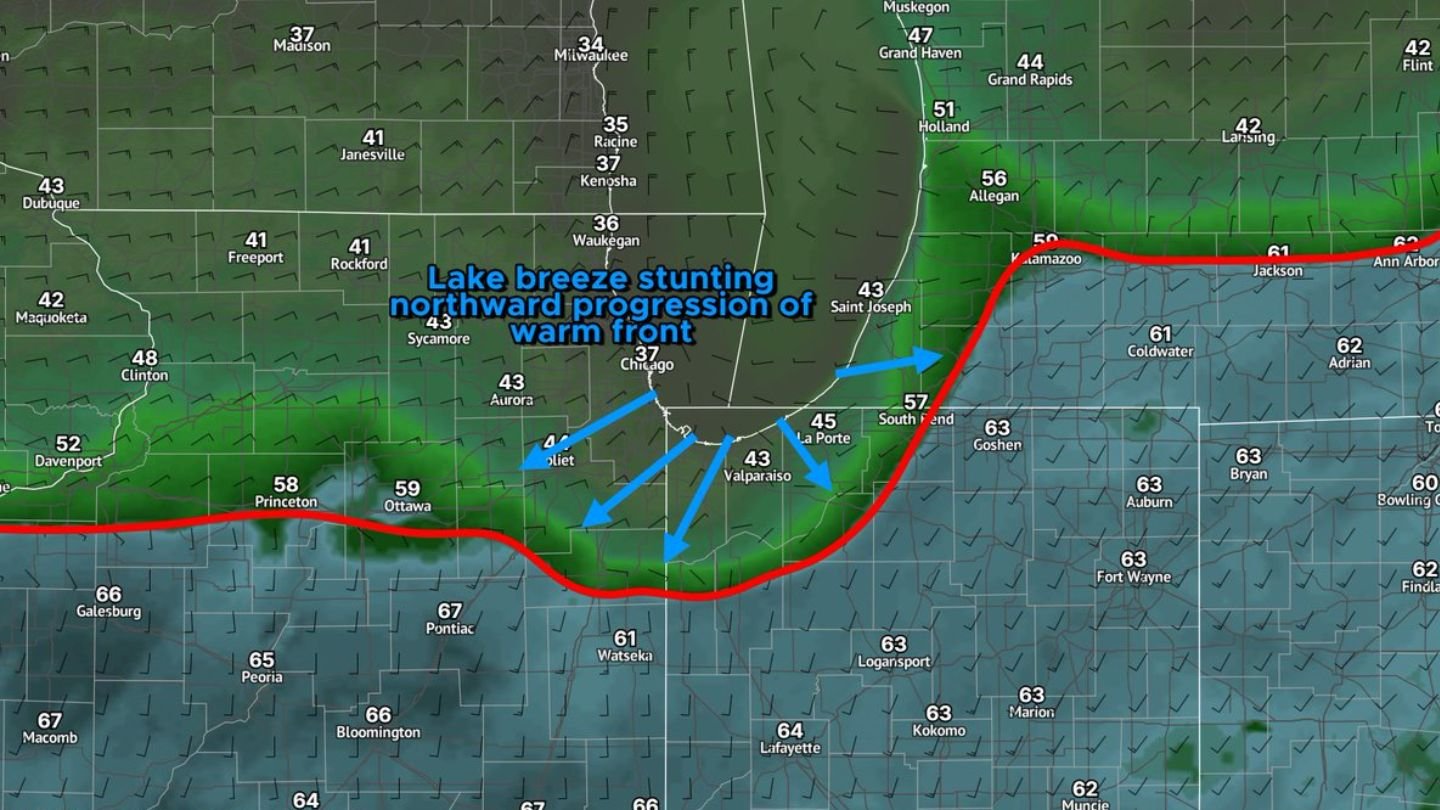
As of 2 p.m. CST, surface analysis shows the lake breeze pushing inland from the Lake Michigan shoreline, spreading cooler air across much of northeast Illinois. Temperatures have dropped into the 30s and low 40s near the lake, including Chicago (37°F), Waukegan (36°F), and Kenosha (37°F), while areas farther south remain firmly in the warm sector with readings in the 60s.
Lake Breeze Forcing Warm Front South
The warm front, marked clearly on the surface map, stretches from eastern Iowa through central Illinois and into northern Indiana and southern Michigan. However, instead of lifting north as expected, it has been forced southward by the strong onshore flow off Lake Michigan.
Communities such as Joliet, Aurora, and Valparaiso are sitting near this boundary, while locations farther south — including Watseka (61°F), Pontiac (67°F), and Bloomington (66°F) — remain entrenched in warmer, more unstable air.
In northwest Indiana, the contrast is especially sharp. South Bend (57°F) and La Porte (45°F) are closer to the lake-modified air, while just to the south and east, temperatures jump into the lower 60s across Goshen (63°F) and Fort Wayne (63°F).
This sharp gradient highlights the power of the lake breeze circulation, which has effectively “stunted” the northward progression of the warm front during the afternoon hours.
Why This Matters for Waldron and Arkansas Readers
While this boundary is centered in Illinois and Indiana, its behavior is a textbook example of how mesoscale features — like lake breezes — can dramatically alter severe weather setups across the Midwest. These same atmospheric principles apply during Arkansas severe weather events, where outflow boundaries and temperature gradients can enhance tornado potential.
The key concern tonight in Illinois and Indiana is what happens after sunset.
Evening Shift Could Reignite Northward Movement
Meteorologists are noting signs that the lake breeze may gradually weaken as it encounters warmer and increasingly unstable air to the south. As the evening progresses, strengthening warm air advection (WAA) and a developing low-level jet (LLJ) could allow the warm front to lift back north.
If that happens, southern portions of the Chicagoland metro and northwest Indiana would re-enter the warm sector — a zone favorable for severe thunderstorms and even tornado development.
Areas of particular concern include:
- Southern Chicago metro
- Joliet and surrounding Will County communities
- Valparaiso and La Porte
- Northwest Indiana counties south of South Bend
When warm fronts retreat northward in the evening while wind shear increases, it often enhances low-level rotation potential in thunderstorms. That combination can quickly escalate from strong storms to tornadic supercells.
Current Temperature Divide Highlights Instability
The map shows an impressive temperature divide:
- 30s near Milwaukee and Racine
- Upper 30s to low 40s across Chicago and Rockford
- Upper 50s in Ottawa and Princeton
- Low to mid 60s south of Interstate 80 and across much of northern Indiana
This kind of sharp boundary is often a focal point for storm initiation and intensification.
What Happens Next
For most of the afternoon, the warm front is expected to remain suppressed, thanks to the persistent lake breeze. However, as winds aloft strengthen toward sunset and the low-level jet ramps up, the balance could shift.
If the warm front surges back north even modestly, storms that develop along or just south of that boundary could rapidly intensify.
Residents across northeast Illinois and northwest Indiana are urged to remain weather aware through the evening and overnight hours.
At WaldronNews.com, we closely monitor severe weather setups across the Midwest because the same atmospheric dynamics frequently impact Arkansas during peak storm season. Stay tuned for continued updates as forecasters evaluate whether the warm front regains ground and how that may influence the severe storm and tornado risk tonight.